
Gavarret-sur-Aulouste
| Gavarret-sur-Aulouste | ||
|---|---|---|
|
||
| region | Occitania | |
| Department | Gers | |
| Arrondissement | Condom | |
| Canton | Fleurance-Lomagne | |
| Community association | Communes de la Lomagne Gersoise | |
| Coordinates | 43 ° 46 ′ N , 0 ° 39 ′ E | |
| height | 94-201 m | |
| surface | 8.38 km 2 | |
| Residents | 142 (January 1, 2017) | |
| Population density | 17 inhabitants / km 2 | |
| Post Code | 32390 | |
| INSEE code | 32142 | |
| Website | Gavarret-sur-Aulouste | |
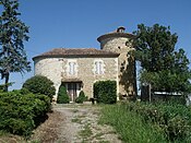
 Former school and mayor's office ( Mairie ) |
||

Gavarret-sur-Aulouste is a French commune with 142 inhabitants (as of January 1, 2017) in the Gers department in the Occitanie region (before 2016: Midi-Pyrénées ). The municipality belongs to the Arrondissement Condom and the canton of Fleurance-Lomagne (until 2015: canton of Fleurance ).
The inhabitants are called Gavarretois and Gavarretoises .
geography
Gavarret-sur-Aulouste is located about 31 kilometers southeast of Condom and about 15 kilometers north-northeast of Auch in the historic province of Armagnac .
Gavarret-sur-Aulouste is surrounded by the five neighboring municipalities:
| Lalanne | ||
| Montestruc-sur-Gers |
.svg)
|
Miramont-Latour |
| Sainte-Christie | Mirepoix |
Waters
Gavarret-sur-Aulouste lies in the catchment area of the Garonne River .
The Gers , a left tributary of the Garonne, flows along a short section of the northern municipal boundary. The Aulouste forms the natural border with the neighboring municipalities of Montestruc-sur-Gers and Sainte-Christie, where it flows into the Gers. Gavarret-sur-Aulouste is also irrigated by the Ruisseau du Haou.
Population development
After records began, the population rose to a peak of 430 at the beginning of the 19th century. In the following period, the size of the community fell with intermittent recovery phases until the 1990s to its lowest level of around 120 inhabitants, before a phase of moderate growth began, which continues to this day.
| year | 1962 | 1968 | 1975 | 1982 | 1990 | 1999 | 2006 | 2011 | 2017 |
|---|---|---|---|---|---|---|---|---|---|
| Residents | 133 | 132 | 125 | 132 | 121 | 129 | 133 | 132 | 142 |

Attractions
- Parish church of Sainte-Magdeleine, a Romanesque building from the 11th century with a Gothic entrance portal
- A tower as a remnant of a former feudal lord's castle
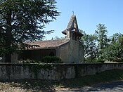
Parish Church of Sainte-Magdeleine
Tower as a remnant of a former castle


Economy and Infrastructure

|

|
|
|
Bas Armagnac
Château de Mauhic 1986 |
Floc de Gascogne blanc and rosé
|
Gavarret-sur-Aulouste is in the AOC zones
- des Armagnacs (Armagnac, Bas-Armagnac, Haut-Armagnac, Armagnac-Ténarèze and Blanche Armagnac) and
- of the liqueur wine Floc de Gascogne (blanc, rosé).

Total = 23
traffic
Gavarret-sur-Aulouste can be reached via the routes départementales 240, 241 and 251.
Web links
- Gavarret-sur-Aulouste on the Association of Municipalities website (French)
- Website of the Bureau National Interprofessionnel de l'Armagnac (French)
- Website of the Comité Interprofessionnel du Floc de Gascogne (French)
Individual evidence
- ↑ Gers ( fr ) habitants.fr. Retrieved December 24, 2019.
- ↑ Ma commune: Gavarret-sur-Aulouste ( fr ) Système d'Information sur l'Eau du Bassin Adour Garonne. Retrieved December 18, 2019.
- ↑ Notice Communale Gavarret-sur-Aulouste ( fr ) EHESS . Retrieved December 24, 2019.
- ↑ Populations légales 2016 Commune de Gavarret-sur-Aulouste (32142) ( fr ) INSEE . Retrieved December 24, 2019.
- ↑ Institut national de l'origine et de la qualité: Rechercher un produit ( fr ) Institut national de l'origine et de la qualité . Retrieved December 24, 2019.
- ↑ Caractéristiques des établissements en 2015 Commune de Gavarret-sur-Aulouste (32142) ( fr ) INSEE . Retrieved December 18, 2019.