Mauléon-d'Armagnac
|
Mauléon-d'Armagnac Mauleon d'Armanhac |
||
|---|---|---|
|
|
||
| region | Occitania | |
| Department | Gers | |
| Arrondissement | Condom | |
| Canton | Grand-Bas-Armagnac | |
| Community association | Grand Armagnac | |
| Coordinates | 43 ° 54 ′ N , 0 ° 9 ′ W | |
| height | 68-153 m | |
| surface | 35.13 km 2 | |
| Residents | 275 (January 1, 2017) | |
| Population density | 8 inhabitants / km 2 | |
| Post Code | 32240 | |
| INSEE code | 32243 | |
Mauléon-d'Armagnac ( Occitan Mauleon d'Armanhac ) is a French commune with 275 inhabitants (as of January 1, 2017) in the Gers department in the Occitania region (until 2015 Midi-Pyrénées ). It belongs to the Arrondissement Condom and the Grand Armagnac community association founded in 1999 . The residents call themselves Mauléonais .
geography
The municipality of Mauléon-d'Armagnac is located in the Armagnac countryside in the extreme northwest of the Gers department, about 30 kilometers east of Mont-de-Marsan and 70 kilometers northwest of Auch . In the north, the municipality borders on the Landes department . The landscape of the 35.13 km² municipal area shows a constant change of fields, meadows, small wooded areas, vines and reservoirs. The rivers of the municipality drain in the southwest half of the Midour , in the northeast half of the Douze - both rivers belong to the catchment area of the Adour . The community has the character of a scattered settlement and consists of numerous hamlets and several individual farms. The largest hamlets are Lartigue, Pichet, Jouanchicot, Lauga, Cucassé, Perrix, Soubère, La Hitte and Pébernère . The town hall ( Mairie ) is in the centrally located hamlet of Mauléon , the churches in Mauléon, Cucassé, Soubère and in the open field at La Tuilerie . Mauléon-d'Armagnac is surrounded by the neighboring communities Labastide-d'Armagnac (Département Landes) in the north, Monclar in the east, Estang in the southeast, Castex-d'Armagnac in the south and Lannemaignan in the northwest.
history
In today's municipality of Mauléon-d'Armagnac, the former four parishes of Mauléon, Cucassé, Soubère and Bréchan, which formerly belonged to the diocese of Aire-sur-Adour in the Landes department, are combined.
The community was called Mauléon when it was founded after the French Revolution . The nans addition -d'Armagnac was only introduced in 1893.
Population development
| year | 1962 | 1968 | 1975 | 1982 | 1990 | 1999 | 2005 | 2016 |
| Residents | 583 | 523 | 414 | 369 | 311 | 306 | 287 | 278 |
| Source: Cassini and INSEE | ||||||||
Culture and sights
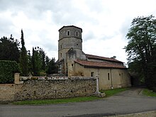
- Sainte-Madeleine church in Mauléon with an octagonal tower
- Bréchan church near the La Tuilerie district
- Church in the district of Cucassé
- Church in the Soubère district
- Castle Maniban, Renaissance mansion with origins from the 14th century, now inaccessible privately owned and for visitors as Monument historique classified
The most important festival in the municipality takes place on the 4th Sunday in July.
Economy and Infrastructure
Larger vineyards can be found around the suburbs of Lauga, Cucassé, Mauléon and La Hitte. They are part of the Sod-Ouest wine-growing region . It mainly produces wines for the production of Armagnac and Floc de Gascogne . Mauléon-d'Armagnac is home to 26 winegrowers and a further 46 farms (cereal and feed cultivation, cattle and poultry breeding, dairy farming).
The N 524 trunk road from Roquefort to Eauze runs through the northeast of the municipality of Mauléon-d'Armagnac . The next motorway junction is about 20 kilometers to the west, near Mont-de-Marsan , on the A 65 autoroute from Langon to Pau .
supporting documents
- ↑ Presentation on the community association homepage (French)
- ↑ toponym on cassini.ehess.fr (French)
- ↑ Mauléon-d'Armagnac on cassini.ehess.fr (French)
- ↑ Mauléon-d'Armagnac on INSEE
- ↑ Château de Maniban in the Base Mérimée of the Ministry of Culture. Retrieved December 30, 2019 (French).
- ↑ Farms on annuaire-mairie.fr (French)


