
Zemmer
| coat of arms | Germany map | |
|---|---|---|

|
Coordinates: 49 ° 54 ' N , 6 ° 42' E |
|
| Basic data | ||
| State : | Rhineland-Palatinate | |
| County : | Trier-Saarburg | |
| Association municipality : | Trier country | |
| Height : | 360 m above sea level NHN | |
| Area : | 24.38 km 2 | |
| Residents: | 3061 (Dec. 31, 2019) | |
| Population density : | 126 inhabitants per km 2 | |
| Postal code : | 54313 | |
| Area code : | 06580 | |
| License plate : | TR, SAB | |
| Community key : | 07 2 35 151 | |
| Community structure: | 4 districts | |
| Association administration address: | Gartenfeldstrasse 12 54295 Trier |
|
| Website : | ||
| Local Mayor : | Edgar Schmitt ( SPD ) | |
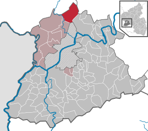
| Location of the local community Zemmer in the district of Trier-Saarburg | ||
  |
||


|

|
|
|
St. Remigius (Zemmer)
|
St. Martin (Schleidweiler)
|
Zemmer is a municipality in the district of Trier-Saarburg , Rhineland-Palatinate . It belongs to the Trier-Land community .
geography
location
Zemmer is located in the middle of the Trier - Bitburg - Wittlich triangle, about 15 kilometers north-northeast of Trier.
Community structure
The local community Zemmer consists of the local districts Zemmer (1141 inhabitants), Rodt (1018), Schleidweiler (615) and Daufenbach (160). Zemmer is the core of a regionally known local association, the Fidei . Fidei includes the villages of Zemmer, Rodt and Schleidweiler as well as Orenhofen and Preist .
Local District Daufenbach also include residential places Deimlingermühle, Forstgut Euleneck, the fundamental digging, Muhlenberg and Mühlenflürchen, Local District Zemmer the residential places Forsthaus Mülchen, Nice Felderhof, Paulushof, Corneliushof, Kapellenhof, Johanneshof, Rosenhof, House King soaps and on the gallows field.
climate
The annual precipitation is 823 mm. The precipitation is in the upper third of the values recorded in Germany. Lower values are registered at 67% of the measuring stations of the German Weather Service . The driest month is February, with the most rainfall in November. In November there is 1.4 times more rainfall than in February. Precipitation varies only minimally and is extremely evenly distributed over the year. Lower seasonal fluctuations are recorded at only 1% of the measuring stations .
history
Zemmer 893 was first mentioned in the Prümer Urbar . On March 7, 1945, during the final phase of World War II , the 2nd US Cavalry Regiment captured the city. On March 17, 1974, the previously independent municipality Schleidweiler-Rodt was incorporated.
- Population development
Development of the population of Zemmer in relation to today's municipal area; the values from 1871 to 1987 are based on censuses :.
|
|

Municipal council
- SPD : 5
- FWG : 8
- CDU : 2nd
- Flat share : 5
The municipal council in Zemmer consists of 20 council members, who were elected in a personalized proportional representation in the local elections on May 26, 2019 , and the honorary local mayor as chairman.
| choice | SPD | CDU | FWG * | WGR | total |
|---|---|---|---|---|---|
| 2019 | 5 | 2 | 8th | 5 | 20 seats |
| 2014 | 6th | 3 | 7th | 4th | 20 seats |
| 2009 | 5 | 3 | 8th | 4th | 20 seats |
* FWG = Free Voting Group Fidei e. V.
traffic
Rail transport
The Daufenbach train station in the same Zemmerer district is located on the Eifel circuit ( Cologne - Euskirchen - Gerolstein - Trier ) on which the rail passenger transport under the brand name Vareo the Eifel-Express (RE / RB 22) Cologne - Euskirchen - Gerolstein - Trier with vehicles in the series 620 and series 622 in service.
Hiking trails
Zemmer and the Rodt district are on the Eifelsteig long-distance hiking trail , which runs through Zemmer on its 14th stage from Bruch to Kordel. At the highest geographical point on Friedbüsch in Rodt, there is a 20 m high wooden observation tower built in 1993 directly on the hiking trail . This is also where all the Fidei Nordic Walking Parcours meet.
Plane crash
On October 8, 2019, at around 3:15 p.m., an American F-16 fighter jet stationed at Spandahlem Air Base and manned by a pilot crashed over a forest in the area of the municipality of Zemmer; the pilot was able to save himself with his ejector seat and survived slightly injured. The crash site is below the K 34 district road near the Zemmer-Rodt district.
See also
Web links
- Internet presence of the local community Zemmer
- To search for cultural assets of the local community Zemmer in the database of cultural assets in the Trier region .
- Link catalog on Zemmer at curlie.org (formerly DMOZ )
Individual evidence
- ↑ State Statistical Office of Rhineland-Palatinate - population status 2019, districts, communities, association communities ( help on this ).
- ↑ Robert Reuter: The Fidei - the habitat of our ancestors. Helios, Aachen 2003.
- ↑ State Statistical Office Rhineland-Palatinate (ed.): Official directory of the municipalities and parts of the municipality. Status: January 2019 [ Version 2020 is available. ] . S. 123 (PDF; 3 MB).
- ↑ Entry on findcity.de
- ↑ Chronicle of the 2nd US Cavalry Regiment
- ↑ Official municipality directory (= State Statistical Office of Rhineland-Palatinate [Hrsg.]: Statistical volumes . Volume 407 ). Bad Ems February 2016, p. 183 (PDF; 2.8 MB).
- ↑ State Statistical Office Rhineland-Palatinate - regional data
- ^ The Regional Returning Officer Rhineland-Palatinate: Local elections 2019, city and municipal council elections
- ↑ Eifelsteig stage 14 on the website of Eifel Tourismus (ET) GmbH
- ^ Entry on the observation tower at the sports field in the database of cultural assets in the Trier region ; accessed on December 17, 2017.
- ↑ Nordic Walking Parcours Fidei on eifel.de

Aach | Ayl | Baldringen | Bekond | Notification | Beuren (high forest) | Bonerath | Damflos | Detzem | Ensch | Farschweiler | Fur | Fish | Pine | Franzenheim | Freudenburg | Geisfeld | Greimerath | Grimburg | Gusenburg | Gusterath | Gutweiler | Heddert | Stalling | Herl | Hermeskeil | Hinzenburg | Hinzert-Pölert | Hockweiler | Holzerath | Hedgehog | Irsch | Kanzem | Chasuble | Kastel-Staadt | Kell am See | Kenn | Kirf | Klüsserath | Conc | Cord | Korlingen | Köwerich | Lampades | Langsur | Leiwen | Lunge | Longuich | Lorscheid | Mandern | Mannebach | Mehring | Mertesdorf | Merzkirchen | Morscheid | Naurath (Eifel) | Naurath (forest) | Neuhütten | Newel | Nittel | Upper cheap | Ockfen | Ollmuth | Onsdorf | Osburg | Palzem | Paschel | Pellingen | Pluwig | Pölich | Ralingen | Swift oath | Reinsfeld | Riol | Riveris | Saarburg | Schillings | Schleich | Schoden | Schömerich | Schondorf | Schweich | Serrig | Sommerau | Taben-Rodt | Tawern | Temmels | Thomm | Thörnich | Trassem | Trierweiler | Trittenheim | Vierherrenborn | Waldrach | Waldweiler | Wasserliesch | Wawern | Waves | Welschbillig | Wiltingen | Wincheringen | Zemmer | Zerf | Züsch