
Beuren (high forest)
| coat of arms | Germany map | |
|---|---|---|

|
Coordinates: 49 ° 44 ' N , 6 ° 55' E |
|
| Basic data | ||
| State : | Rhineland-Palatinate | |
| County : | Trier-Saarburg | |
| Association municipality : | Hermeskeil | |
| Height : | 545 m above sea level NHN | |
| Area : | 18.5 km 2 | |
| Residents: | 925 (Dec. 31, 2019) | |
| Population density : | 50 inhabitants per km 2 | |
| Postal code : | 54413 | |
| Area code : | 06586 | |
| License plate : | TR, SAB | |
| Community key : | 07 2 35 008 | |
| LOCODE : | DE EUD | |
| Community structure: | 2 districts | |
| Association administration address: | Langer Markt 17 54411 Hermeskeil |
|
| Website : | ||
| Mayoress : | Petra Adams-Philippi | |
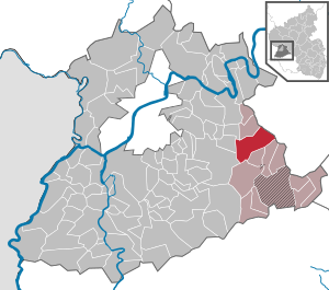
| Location of the local community Beuren (Hochwald) in the district of Trier-Saarburg | ||
 _in_TR.svg) |
||


Beuren (Hochwald) is a municipality in the Trier-Saarburg district in Rhineland-Palatinate . It belongs to the Hermeskeil community .
geography
Beuren is located in the Saar-Hunsrück Nature Park about 20 km east of Trier .
Immediate neighboring communities are: Schönberg , Neunkirchen , Burtscheid , Rascheid , Hinzert-Pölert , Reinsfeld , Osburg , Farschweiler , Lorscheid and Bescheid .
The community is divided into the two districts Beuren and Prosterath with the residential area Waldmühle.
Beuren (Hochwald) is the name of the measuring table sheet No. 6207 of the topographic map on a scale of 1: 25,000.
history
The community has had the suffix "(Hochwald)" since December 1, 1969. On March 17, 1974, Prosterath was incorporated into Beuren (Hochwald) with 209 inhabitants at that time.
Beuren (high forest)
Archbishop Theoderich II. , Formerly provost of St. Paulin himself , gave the monastery the parish in 1231, which is called "Buren" (fountain, born) in the document of 1255. On the choir of the church, built in 1836/38 in the classical style, there is a stone inscription with the number 1414, the year of construction of the old Gothic predecessor church.
At the beginning of the 19th century, Beuren became the seat of the mayor's office .
Prosterath
Prosterath coat of arms
Prosterather Wacken

Prosterather Wacken


In 1023 the provost of St. Maximin owned "Probesderuot" (provost regulation), in 1701 the first chapel was mentioned. In the 18th / 19th In the 18th century, Peter Cornely ran an outpatient bell foundry here.
Population development
The development of the population of Beuren (Hochwald) in relation to today's municipality, the values from 1871 to 1987 are based on censuses:
|
|
politics
Municipal council
The local council in Beuren consists of twelve council members, who were elected in a personalized proportional representation in the local elections on May 26, 2019 , and the honorary local mayor as chairman.
The distribution of seats in the municipal council:
| choice | SPD | CDU | WGR 1 | WGR 2 | total |
|---|---|---|---|---|---|
| 2019 | - | - | 4th | 8th | 12 seats |
| 2014 | 5 | - | 2 | 5 | 12 seats |
| 2009 | 7th | 3 | 2 | - | 12 seats |
| 2004 | 7th | 4th | 1 | - | 12 seats |
mayor
- Petra Adams-Philippi has been the local mayor since 2014, replacing Manfred Köhl.
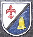
coat of arms
|
|
Blazon : "Divided by silver and red obliquely on the left, in front a rising bend, behind a silver lily." |
| Founding of the coat of arms: The previously independent municipalities of Beuren and Prosterath were merged into one municipality through the administrative reform in 1974. For the former community of Prosterath, the lily, the attribute of St. Antony, taken. It stands in the new coat of arms for Beuren in the back field. The former municipality of Beuren is mentioned in a document in 1255. The document confirms that Beuren belonged to St. Paulin Abbey in Trier during the reign of Archbishop Theoderich II (1212–1242). The front coat of arms indicates this affiliation. It shows a rising curvature in the Electoral Trier colors of red and silver. The abbot's staff is a symbol of belonging to the Electorate of Trier St. Paulin. The creation of the coat of arms goes back to a design by Pastor P. Schwarz, Beuren, and a proposal by the State Archives. Here the ideal form of the formation of a coat of arms has succeeded, since it has only one metal (silver) and only one color (red). A requirement that has been striven for in heraldry again and again, but only rarely achieved. |
Culture and sights
Buildings
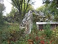
Natural monuments
- Chain of rocks
- see: List of natural monuments in Beuren (high forest)
Economy and Infrastructure
traffic
- Bus connection to Hermeskeil , in Hermeskeil on to Trier or Türkismühle .
education
- Elementary school and kindergarten
Others
In Beuren there is a group practice and a pharmacy as well as shops for food, beverages and a branch of Sparkasse Trier .
Web links
- To search for cultural assets of the local community Beuren (Hochwald) in the database of cultural assets in the Trier region .
- Literature about Beuren in the Rhineland-Palatinate State Bibliography
- Short portrait of Beuren ( memento from February 12, 2013 in the web archive archive.today ) on Hierzuland , SWR television
- Link catalog on the topic of Beuren at curlie.org (formerly DMOZ )
Individual evidence
- ↑ State Statistical Office of Rhineland-Palatinate - population status 2019, districts, communities, association communities ( help on this ).
- ↑ State Statistical Office Rhineland-Palatinate (ed.): Official directory of the municipalities and parts of the municipality. Status: January 2019 [ Version 2020 is available. ] . S. 117 (PDF; 3 MB).
- ↑ Deutsche Fotothek : Mestischblatt No. 6207: Beuren, 1936
- ↑ Map Beuren (Hochwald) 2019, DNB 1186092440
- ↑ Official municipality directory 2006 ( Memento from December 22, 2017 in the Internet Archive ) (= State Statistical Office Rhineland-Palatinate [Hrsg.]: Statistical volumes . Volume 393 ). Bad Ems March 2006, p. 171 and 203 (PDF; 2.6 MB). Info: An up-to-date directory ( 2016 ) is available, but in the section "Territorial changes - Territorial administrative reform" it does not give any population figures.
- ↑ State Statistical Office Rhineland-Palatinate: My village, my city. Retrieved September 9, 2019 .
- ^ The Regional Returning Officer Rhineland-Palatinate: Local elections 2019, city and municipal council elections. Retrieved September 9, 2019 .

Aach | Ayl | Baldringen | Bekond | Notification | Beuren (high forest) | Bonerath | Damflos | Detzem | Ensch | Farschweiler | Fur | Fish | Pine | Franzenheim | Freudenburg | Geisfeld | Greimerath | Grimburg | Gusenburg | Gusterath | Gutweiler | Heddert | Stalling | Herl | Hermeskeil | Hinzenburg | Hinzert-Pölert | Hockweiler | Holzerath | Hedgehog | Irsch | Kanzem | Chasuble | Kastel-Staadt | Kell am See | Kenn | Kirf | Klüsserath | Conc | Cord | Korlingen | Köwerich | Lampades | Langsur | Leiwen | Lunge | Longuich | Lorscheid | Mandern | Mannebach | Mehring | Mertesdorf | Merzkirchen | Morscheid | Naurath (Eifel) | Naurath (forest) | Neuhütten | Newel | Nittel | Upper cheap | Ockfen | Ollmuth | Onsdorf | Osburg | Palzem | Paschel | Pellingen | Pluwig | Pölich | Ralingen | Swift oath | Reinsfeld | Riol | Riveris | Saarburg | Schillings | Schleich | Schoden | Schömerich | Schondorf | Schweich | Serrig | Sommerau | Taben-Rodt | Tawern | Temmels | Thomm | Thörnich | Trassem | Trierweiler | Trittenheim | Vierherrenborn | Waldrach | Waldweiler | Wasserliesch | Wawern | Waves | Welschbillig | Wiltingen | Wincheringen | Zemmer | Zerf | Züsch