
Haute-Saône department
| Haute-Saône | |
|---|---|
 |
  |
| region | Bourgogne-Franche-Comté |
| prefecture | Vesoul |
| Sub-prefecture (s) | Lure |
| Residents | 236,659 (Jan. 1, 2017) |
| Population density | 44 inhabitants per km² |
| surface | 5,360.45 km² |
| Arrondissements | 2 |
| Community associations | 19th |
| Cantons | 17th |
| Communities | 539 |
|
President of the Department Council |
Yves Krattinger |
| ISO-3166-2 code | FR-70 |
 Location of the Haute-Saone in the region Bourgogne Franche-Comté |
|
The Haute-Saône [ otsoːn ] (officially Département de la Haute-Saône ) is the French department with the atomic number 70. It is in the east of the country in the Region Bourgogne Franche-Comté . Its name is derived from the Saône river .
geography
The department borders in the north with the department Vosges in Lorraine , in the east with the Territoire de Belfort , the part of Alsace that remained French in 1871 , in the south with the departments Doubs and Jura , also from Franche-Comté , in the south-west with the department Côte -d'Or , part of the former Burgundy region , and to the north-west of the Haute-Marne department , part of the Grand Est region .
The southern foothills of the Vosges occupy the northern part of the department . This is where the Saône rises , giving the department its name and flowing through it in a south-westerly direction.
- landscape

Landscape in the southeast
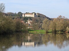
Ray-sur-Saône in the west of the department
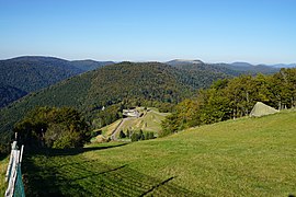
Planche des Belles Filles ( Tour de France ), mountain in the northeast
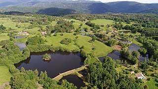
Landscape of the Plateau des Mille Étangs

_-_01.jpg)


history
The department was formed on March 4, 1790 from the north of the former Free County of Burgundy .
The department was also affected by the Franco-Prussian War with the battles of Héricourt and Villersexel , but also by the proximity of the siege of Belfort . The department took in Alsatians who fled from the annexation of Alsace-Lorraine .
- The Franco-Prussian War in Haute-Saône
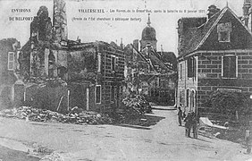
View of the destruction of Villersexel

German artillery in front of the ruins of Villersexel Castle


The department has a significant mining and industrial past (coal, salt, iron, lead-silver-copper mines, bitumen slate, stationery, spinning, weaving, forging, foundries, tiles, mechanical factories).
- Emblematic industries of Haute-Saône
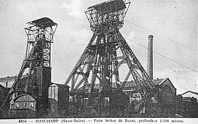
Arthur de Buyer shaft (1,010 m), the deepest coal mine in France between 1900 and 1910

The Gouhenans saltworks was one of the most important saltworks in France in the 19th century

Interior view of the Varigney factory ( Dampierre-lès-Conflans ), the iron industry was developed until the middle of the 20th century
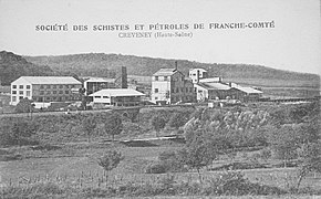
Bitumen shale distillation plant Creveney between the two world wars
.jpg)


From 1960 to 2015 it was part of the Franche-Comté region, which in 2016 became part of the Bourgogne-Franche-Comté region.
coat of arms
Description: In blue a golden lion with a crown, red tongue and claws between sown golden shingles , above a red wave shield head with a silver wave bar .
Cities
The most populous communes in the Haute-Saône department are:
| city | Population (2017) |
Arrondissement |
|---|---|---|
| Vesoul | 14,916 | Vesoul |
| Héricourt | 10,601 | Lure |
| Lure | 8,207 | Lure |
| Luxeuil-les-Bains | 6,722 | Lure |
| Gray | 5,512 | Vesoul |
Administrative division
The Haute-Saône department is divided into 2 arrondissements , 17 cantons and 539 communes :

| Arrondissement | Cantons | Communities | Residents January 1, 2017 |
Area km² |
Density of population / km² |
Code INSEE |
|---|---|---|---|---|---|---|
| Lure | 10 | 193 | 108,803 | 1,906.22 | 57 | 701 |
| Vesoul | 11 | 346 | 127,856 | 3,454.23 | 37 | 702 |
| Haute-Saône department | 17th | 539 | 236,659 | 5,360.45 | 44 | 70 |
See also:
- List of communes in the Haute-Saône department
- List of cantons in the Haute-Saône department
- List of associations of municipalities in the Haute-Saône department
economy
The department is characterized by agriculture, almost half of its area is used as arable land and pasture land, another third is covered by forest. Well-known dairy products in the region are Comté cheese and Morbier cheese with the famous ash stripe.
Web links
- Haute-Saône (French)
- Prefecture of the Haute-Saône (French)
Individual evidence
- ↑ haute-saone.fr accessed on May 1, 2015.
01 Ain | 02 Aisne | 03 Allier | 04 Alpes-de-Haute-Provence | 05 Hautes-Alpes | 06 Alpes-Maritimes | 07 Ardèche | 08 Ardennes | 09 Ariège | 10 Aube | 11 Aude | 12 Aveyron | 13 Bouches-du-Rhône | 14 Calvados | 15 Cantal | 16 Charente | 17 Charente-Maritime | 18 Cher | 19 Corrèze | 21 Côte-d'Or | 22 Côtes-d'Armor | 23 Creuse | 24 Dordogne | 25 Doubs | 26 Drôme | 27 Your | 28 Eure-et-Loir | 29 Finistère | 30 Gard | 31 Haute-Garonne | 32 Gers | 33 Gironde | 34 Hérault | 35 Ille-et-Vilaine | 36 Indre | 37 Indre-et-Loire | 38 Isère | 39 Jura | 40 Landes | 41 Loir-et-Cher | 42 Loire | 43 Haute-Loire | 44 Loire-Atlantique | 45 Loiret | 46 Lot | 47 Lot-et-Garonne | 48 Lozère | 49 Maine-et-Loire | 50 Some | 51 Marne | 52 Haute-Marne | 53 Mayenne | 54 Meurthe-et-Moselle | 55 Meuse | 56 Morbihan | 57 Moselle | 58 Nièvre | 59 North | 60 Oise | 61 Orne | 62 Pas-de-Calais | 63 Puy-de-Dôme | 64 Pyrénées-Atlantiques | 65 Hautes-Pyrénées | 66 Pyrénées-Orientales | 67 Bas-Rhin | 68 Haut-Rhin | 69D Rhône | 69M Métropole de Lyon (from 2015) | 70 Haute-Saône | 71 Saône-et-Loire | 72 Sarthe | 73 Savoie | 74 Haute-Savoie | 75 Paris (from 1968) | 76 Seine-Maritime | 77 Seine-et-Marne | 78 Yvelines (from 1968) | 79 Deux-Sèvres | 80 Somme | 81 Tarn | 82 Tarn-et-Garonne | 83 Var | 84 Vaucluse | 85 Vendée | 86 Vienne | 87 Haute-Vienne | 88 Vosges | 89 Yonne | 90 Territoire de Belfort | 91 Essonne (from 1968) | 92 Hauts-de-Seine (from 1968) | 93 Seine-Saint-Denis (from 1968) | 94 Val-de-Marne (from 1968) | 95 Val-d'Oise (from 1968)
Overseas Departments (DOM)
971 Guadeloupe |
972 Martinique |
973 French Guiana |
974 Réunion |
976 Mayotte
Départements
20 Corse
dissolved after 1962 (until 1975) | 2A Corse-du-Sud (1976-2017) |
2B Haute-Corse (1976-2017) |
75 Seine (until 1967) |
78 Seine-et-Oise (until 1967)
Coordinates: 47 ° 37 ' N , 6 ° 8' E