District of Halle (Westphalia)
| coat of arms | Germany map |
|---|---|

|

Coordinates: 52 ° 4 ′ N , 8 ° 22 ′ E |
| Basic data (as of 1972) | |
| Existing period: | 1816-1972 |
| State : | North Rhine-Westphalia |
| Administrative region : | Detmold |
| Regional association : | Westphalia-Lippe |
| Administrative headquarters : | Halle (Westphalia) |
| Area : | 305.13 km 2 |
| Residents: | 69,700 (Dec. 31, 1971) |
| Population density : | 228 inhabitants per km 2 |
| License plate : | HW |
| Circle key : | 05 7 34 |
| Circle structure: | 23 municipalities |
| Address of the district administration: |
Ravensberger Strasse 1 4802 Halle (Westphalia) |
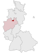
| Location of the Halle district in North Rhine-Westphalia | |
The district of Halle (Westf.) (1939-1969: Landkreis Halle (Westf.) ) Was a district in eastern North Rhine-Westphalia that existed from 1816 to 1972 . The district was initially part of the administrative district of Minden in the Prussian province of Westphalia , from 1946/47 part of the North Rhine-Westphalian administrative district of Detmold . The administrative seat was Halle (Westphalia) . The district was opened in 1973 as part of the North Rhine-Westphalian regional reform in the newly founded Gütersloh district .
Neighboring areas
At the beginning of 1972, the Halle district bordered clockwise in the north, beginning with the districts of Osnabrück and Melle (both in Lower Saxony ) and the districts of Herford , Bielefeld and Warendorf (all in North Rhine-Westphalia).
history
prehistory
The area of the Halle district belonged to the Prussian administrative area Minden-Ravensberg until 1806 and formed the southwestern part of the Ravensberg county . ( Office Ravensberg and parts of the Office Sparrenberg).
In 1806 the area came under the rule of Napoleonic France . From 1807 to 1810 the later district area was completely part of the French vassal state Kingdom of Westphalia , which received an administrative structure based on the French model. In the Bielefeld district of the Weser Department , the three cantons Halle, Versmold and Werther were formed. The cantons were subdivided into municipalities , also called Mairien , including the municipalities Brockhagen, Borgholzhausen, Halle, Versmold, Steinhagen and Werther.
From 1811 the western parts of the later district area were incorporated directly into the empire; the eastern, much smaller part of the later district area remained as canton Brockhagen in the Kingdom of Westphalia (still in the district of Bielefeld, now in the department of Fulda ). In part, the Haller Laibach formed the border between France and the Kingdom of Westphalia, which divided the city in two. The areas now belonging to the empire were completely attached to the department of the Upper Ems . The cantons of Werther and the smaller canton of Halle were assigned to the Minden district within this department and the canton of Versmold to the Osnabrück district .
After the reconquest by Prussia in 1813, the later district area was provisionally part of the civil government between the Weser and Rhine from 1813 until the founding of the Prussian province of Westphalia .
Administrative history
The administrative district of Minden , founded in 1816 , one of three administrative districts in the province of Westphalia, was divided into twelve districts with effect from November 1, 1816 by ordinance of the royal government in Minden of October 18, 1816, including the Halle district with its seat in Halle (Westf .). The district was initially subdivided into the four administrative districts Borgholzhausen, Halle, Versmold and Werther, some of which were also referred to as mayorships or cantons .
This only changed with the rural community order for the province of Westphalia from 1841, which was introduced in the Halle district in 1843. The four offices of Halle , Borgholzhausen , Werther and Versmold were set up as administrative bodies between the district level and the community level.
In 1910 the district consisted of the following offices, communities and manor districts:
| Office | Municipalities and manor districts | Office structure |
|---|---|---|
| Borgholzhausen | Barnhausen , Berghausen , Borgholzhausen (town), Brincke (manor district), Casum , Cleve , Hamlingdorf , Holtfeld , Kleekamp , Oldendorf near Borgholzhausen , Ostbarthausen , Westbarthausen , Wichlinghausen and Winkelshütten | |
| Hall | Amshausen , Ascheloh , Bokel , Brockhagen , Eggeberg , Gartnisch , Halle (Westf.) (City), Hesseln , Hörste , Kölkebeck , Künsebeck , Oldendorf near Halle , Patthorst (manor district) and Steinhagen | |
| Versmold | Bockhorst , Hesselteich , Loxten , Oesterweg , Peckeloh and Versmold (city) | |
| Werther | Häger , Isingdorf , Rotenhagen , Rotingdorf , Theenhausen , Schröttinghausen and Werther (city) |
In 1928 the Patthorst manor district was incorporated into Brockhagen. In the same year the Brincke manor district was merged with the communities of Winkelshütten and Barnhausen to form the new community of Brincke, which was renamed Barnhausen in 1929 . On October 1, 1938, the community of Oldendorf b. Halle amalgamated from the Halle office into the city of Halle. On October 1, 1956, part of the Gartnisch community followed, also from the Halle office.
As part of the North Rhine-Westphalian regional reform, the law on the reorganization of municipalities in the Halle district of June 24, 1969 began on July 1, 1969 with the reorganization of the municipalities of the district, the number of which was reduced from 37 to 23. At this point in time the new city of Borgholzhausen was formed and the communities Eggeberg, Ascheloh and Gartnisch were incorporated into Halle. The Borgholzhausen office was abolished.
On October 1, 1969, the district became the district of Halle.
With the Bielefeld Act of October 24, 1972, the remaining municipalities were finally restructured on January 1, 1973, the number of which was further reduced to the four cities of Borgholzhausen, Halle, Versmold, Werther and the municipality of Steinhagen that existed today. At the same time, the remaining offices in Halle, Versmold and Werther were canceled. The same law decreed the formation of the Gütersloh district , in which the Halle district, with the exception of a large part of the Schröttinghausen community, which was incorporated into the independent city of Bielefeld , was merged with the Wiedenbrück district.
Location of the Halle district in the Detmold administrative district (1947–1968)
Population development
The following overview shows the population of the Halle district, whose territorial status remained almost unchanged over the entire period. The numbers are census results or their extrapolation. From 1871 and 1946, the figures relate to the local population and from 1925 to the resident population . Before 1871, the population figures were determined using inconsistent survey methods.
|
|
|
|
Economy and Infrastructure
traffic
The district did not have a motorway (the A 33 did not exist then), the closest were the A 2 and the A 30 , both at a distance of about 15 km.
The district was opened up by the federal roads 68 and 476 as well as several district roads.
The Haller Willem is a branch line near the Teutoburg Forest and connects Osnabrück via Halle with Bielefeld.
politics
Results of the district elections from 1946
The list only shows parties and constituencies that received at least two percent of the votes in the respective election.
Share of votes of the parties in percent
| year | CDU | SPD | FDP | BHE |
|---|---|---|---|---|
| 1946 1 | 46.9 | 40.0 | 6.6 | |
| 1948 | 40.6 | 45.3 | 12.2 | |
| 1952 | 29.6 | 40.7 | 19.7 | 6.5 |
| 1956 | 31.0 | 44.9 | 17.6 | 6.5 |
| 1961 | 33.9 | 43.0 | 16.9 | 6.2 |
| 1964 | 34.5 | 45.5 | 16.7 | 3.3 |
| 1969 2 | 43.6 | 41.7 | 11.3 |
Footnotes
1 1946: additionally: KPD: 2.0%
2 1969: additionally: NPD: 3.4%
District administrators
- 1816–1818 Franz von Korff called Schmising-Kerssenbrock
- 1818–1831 Friedrich von der Betten
- 1831–1855 August Ferdinand Conrad zur Hellen
- 1855–1875 Klemens von Korff called Schmising II , Tatenhausen
- 1875–1896 Georg zu Ysenburg and Büdingen-Philippseich
- 1896–1911 Klemens von Korff called Schmising IV , Tatenhausen
- 1911–1922 Siegfried Roehrig
- 1922–1933 Alfred von Campe
- 1933–1934 Hans Ummen , deputy district administrator, later district judge in Münster
- 1934–1945 Karl Friedrich Emil Leweke
- 1945–1946 Heinrich Wellenbrink (1896–1974), com. District administrator, then senior district director
- 1946 Heinrich Wolf , foreman, Halle
- 1946–1948 Otto Rahe, businessman, Versmold
- 1948–1952 Heinrich Wolf, foreman, Halle
- 1952–1958 Joachim Upmeyer , businessman and farmer, Borgholzhausen
- 1958–1963 Fritz Ostmeyer , farmer, Westbarthausen
- 1963–1964 Heinrich Wolf, foreman, Halle
- 1964–1969 Fritz Ostmeyer, farmer, Westbarthausen
Otto Rahe, Fritz Ostmeyer, Joachim Upmeyer and Heinrich Wolf were volunteers.
Senior District Directors (1945–1972)
- 1945–1946 Heinrich Wellenbrink, come. District administrator, then senior district director
- 1947–1958 Gerhard Treviranus
- 1959–1970 Gerhard Treviranus
- 1970–1972 Klaus Baltzer
coat of arms
The two-part heraldic shield shows a black raven on a golden mountain on a blue background. This symbolizes the former belonging to the County of Ravensberg in a vivid way and has its origin in the oldest known coat of arms of a Ravensberg ruler. The back field shows the rafters of the coat of arms of Grafschaft Ravensberg. The coat of arms was awarded on September 15, 1947. The rafters of the coat of arms of the Halle district have found their way into the coat of arms of the successor district of Gütersloh .
License Plate
On July 1, 1956, the district was assigned the distinctive sign HW with the introduction of the license plates that are still valid today . It was issued until December 31, 1972.
literature
- Uwe Heckert: Halle in Westphalia: history (s) of a city in the Teutoburg Forest . Publishing house for regional history, 2005, ISBN 978-3-89534-560-9 .
- District of Halle / Westf. (Ed.): 150 years of the Halle district (Westphalia) . Self-published, 1966.
- Heinrich Meise: The district of Halle (Westphalia) district and city handbooks of the Westphalian Heimatbund , Volume 13 . Regensberg, 1950.
Web links
- Municipal directory 1900
- Law on the reorganization of municipalities in the Halle district of June 24, 1969
Individual evidence
- ↑ Division of those cantons of the Bielefeld district, in the Weser department, in which two municipalities are supposed to be located. In: Law Bülletin of the Kingdom of Westphalia. May 18, 1808, pp. 135 f. , accessed on February 2, 2014 (digitized version).
- ↑ Westfalenlexikon 1832-1835 . In: Landschaftsverband Westfalen-Lippe (Ed.): Reprints for the Westphalian archive maintenance . tape 3 . Münster 1978, p. 144 (reprint of the original from 1834).
- ↑ Rural community regulations for the province of Westphalia 1841 (PDF; 1.6 MB)
- ^ Ministry of the Interior of the State of North Rhine-Westphalia, Citizens' Service: Law for the reorganization of communities in the district of Halle
- ↑ Announcement of the new version of the district regulations for the state of North Rhine-Westphalia from August 11, 1969 in the Law and Ordinance Gazette for the state of North Rhine-Westphalia, year 1969, No. 2021, p. 670 ff.
- ^ Ministry of the Interior of the State of North Rhine-Westphalia, Citizen Service: Bielefeld Law
- ^ Federal Statistical Office (ed.): Historical municipality directory for the Federal Republic of Germany. Name, border and key number changes in municipalities, counties and administrative districts from May 27, 1970 to December 31, 1982 . W. Kohlhammer, Stuttgart / Mainz 1983, ISBN 3-17-003263-1 , p. 322 f .
- ↑ State Statistical Office of North Rhine-Westphalia: Municipal statistics of the State of North Rhine-Westphalia: population development 1816–1871 . Düsseldorf 1966, pp. 56-59.
- ↑ State Statistical Office of North Rhine-Westphalia: Municipal statistics of the State of North Rhine-Westphalia: Population development 1871–1961 . Düsseldorf 1964, pp. 66-67.
- ↑ State Statistical Office of North Rhine-Westphalia: The resident population in the municipalities of North Rhine-Westphalia 1970: Results of the census on May 27, 1970 . Düsseldorf 1972, p. 40.
- ↑ Statistical Yearbook for the Federal Republic of Germany 1973
- ↑ Source: respective issue of the State Statistical Office (LDS NRW), Mauerstr. 51, Düsseldorf, with the election results at the district level.
- ↑ Herwart and Thassilo von der Betten, genealogical tables of the von derdecke family , 1994 p. 138 there: District Administrator was Friedrich Raban Wilhelm Anton von der Betten (1777–1840)
- ↑ Der Minden Ravensberger, born 1976, Gieseking, Bielefeld-Bethel
- ↑ Der Minden Ravensberger, born 1976, Gieseking, Bielefeld-Bethel


