New Hanover County
 New Hanover County Courthouse |
|
| administration | |
|---|---|
| US state : | North Carolina |
| Administrative headquarters : | Wilmington |
| Address of the administrative headquarters: |
County Courthouse 320 Chestnut Street Wilmington, NC 28401-4068 |
| Foundation : | 1729 |
| Made up from: | Bath County |
| Area code : | 001 910 |
| Demographics | |
| Residents : | 202,667 (2010) |
| Population density : | 393.5 inhabitants / km 2 |
| geography | |
| Total area : | 849 km² |
| Water surface : | 334 km² |
| map | |
| Website : www.nhcgov.com | |
New Hanover County is a county in the state of North Carolina in the United States . The county seat is Wilmington , which was named after the Earl of Wilmington .
geography
The county is located in southeast North Carolina, borders the Atlantic Ocean , is approximately 60 km from South Carolina in the southwest and has an area of 849 square kilometers, of which 334 square kilometers are water. It is bordered clockwise by the following counties: Pender County and Brunswick Counties .
New Hanover County is divided into five townships : Cape Fear, Federal Point, Harnett, Masonboro, and Wilmington.
history
New Hanover County was formed in 1729 from parts of the now defunct Bath County. It was named after the royal family in England who were members of the House of Hanover .

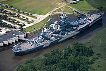
There are two National Historic Landmarks in the county , Fort Fisher and the battleship USS North Carolina . A total of 29 buildings and sites in the county are listed on the National Register of Historic Places (as of March 9, 2018).
Demographic data
| growth of population | |||
|---|---|---|---|
| Census | Residents | ± in% | |
| 1790 | 6831 | - | |
| 1800 | 7060 | 3.4% | |
| 1810 | 11,465 | 62.4% | |
| 1820 | 10,866 | -5.2% | |
| 1830 | 10,959 | 0.9% | |
| 1840 | 13,312 | 21.5% | |
| 1850 | 17,668 | 32.7% | |
| 1860 | 21,715 | 22.9% | |
| 1870 | 27,978 | 28.8% | |
| 1880 | 21,376 | -23.6% | |
| 1890 | 24,026 | 12.4% | |
| 1900 | 25,785 | 7.3% | |
| 1910 | 32,037 | 24.2% | |
| 1920 | 40,620 | 26.8% | |
| 1930 | 43,010 | 5.9% | |
| 1940 | 47,935 | 11.5% | |
| 1950 | 63.272 | 32% | |
| 1960 | 71,742 | 13.4% | |
| 1970 | 82.996 | 15.7% | |
| 1980 | 103,471 | 24.7% | |
| 1990 | 120.284 | 16.2% | |
| 2000 | 160.307 | 33.3% | |
| 2010 | 202,667 | 26.4% | |
| Before 1900
1900–1990 2000 2010 |
|||
According to the 2010 census , New Hanover County had 202,667 people in 86,046 households and 49,980 families. The population density was 393.5 inhabitants per square kilometer. The racial the population was composed of 79.1 percent white, 14.8 percent African American, 0.5 percent Native American, 1.2 percent Asian, 0.1 percent from the Pacific island area and 2.4 percent from other ethnic groups Groups; 2.0 percent were descended from two or more races. Hispanic or Latino of any race were 5.3 percent of the population.
Of the 86,046 households, 17.9 percent had children under the age of 18 living with them. 42.2 percent of all households were married couples living together, 6.8 percent were single mothers. 30.7 percent were single households and 23.6 percent had people 65 years of age or older.
The median income for a household in the 48,553 US dollars .
See also
Web links
Individual evidence
- ↑ GNIS-ID: 1026329. Retrieved on February 22, 2011 (English).
- ↑ Charles Curry Aiken, Joseph Nathan Kane: The American Counties: Origins of County Names, Dates of Creation, Area, and Population Data, 1950-2010 . 6th edition. Scarecrow Press, Lanham 2013, ISBN 978-0-8108-8762-6 , p. 221 .
- ↑ Listing of National Historic Landmarks by State: North Carolina . National Park Service , accessed March 9, 2018.
- ↑ Search mask database in the National Register Information System. National Park Service , accessed March 9, 2018.
- ↑ US Census Bureau - Census of Population and Housing . Retrieved March 15, 2011
- ↑ Extract from Census.gov . Retrieved February 20, 2011
- ↑ Census 2000 PHC-T-4. Ranking Tables for Counties: 1990 and 2000. (PDF; 217.6 kB) In: Census.gov . United States Census Bureau , April 2, 2001, p. 7 , accessed December 22, 2015 .
- ↑ a b American FactFinder. United States Census Bureau , accessed December 22, 2015 .
Coordinates: 34 ° 11 ′ N , 77 ° 52 ′ W
