
Bausendorf
| coat of arms | Germany map | |
|---|---|---|

|
Coordinates: 50 ° 1 ′ N , 7 ° 0 ′ E |
|
| Basic data | ||
| State : | Rhineland-Palatinate | |
| County : | Bernkastel-Wittlich | |
| Association municipality : | Traben-Trarbach | |
| Height : | 177 m above sea level NHN | |
| Area : | 11.86 km 2 | |
| Residents: | 1340 (Dec. 31, 2019) | |
| Population density : | 113 inhabitants per km 2 | |
| Postal code : | 54538 | |
| Area code : | 06532 | |
| License plate : | WIL, BKS | |
| Community key : | 07 2 31 004 | |
| Community structure: | 2 districts | |
| Association administration address: | Am Markt 3 56841 Traben-Trarbach |
|
| Website : | ||
| Local Mayor : | Hans-Peter Heck | |
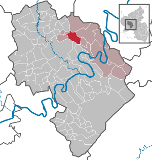
| Location of the local community Bausendorf in the district of Bernkastel-Wittlich | ||
  |
||


Bausendorf is a municipality in the Bernkastel-Wittlich district in Rhineland-Palatinate . It belongs to the Traben-Trarbach community .
geography
The holiday resort of Bausendorf with the district of Olkenbach is protected at the foot of the extensive Kondel forest in the lower Alftal . 55.4 percent of the district area is forested.
history
Around 1250 the Bausendorf chapel is mentioned in the Kaimt regional chapter (Zell / Mosel) in the register of archbishopric rights. Olkenbach was first mentioned in 1075 in a document from Archbishop Udo of Trier , in which the donation of a property to the Simeonstift in Trier was confirmed.
Until the end of the 18th century, Bausendorf belonged to the imperial rule Lösnich , Olkenbach belonged to the Electorate of Trier and was assigned to the Wittlich office and the Neuerburg court.
As a result of the First Revolutionary War , the Left Bank of the Rhine and with it Bausendorf and Olkenbach were taken over by France in 1794 . Both places were assigned to the canton of Wittlich in the Saardepartement from 1798 to 1814 . Due to the agreements made at the Congress of Vienna , both places came to the Kingdom of Prussia in 1815 and were subordinate to the Wittlich district in the Trier administrative district from 1816 . Since 1946, both places have been part of the then newly formed state of Rhineland-Palatinate.
Today's local community was created as part of the administrative reform through the merger of the formerly independent local communities Bausendorf and Olkenbach on June 7, 1969.
- Population development
The development of the population of Bausendorf related to today's municipality area; the values from 1871 to 1987 are based on censuses:
|
|
Municipal council
The local council in Bausendorf consists of 16 council members, who were elected in a personalized proportional representation in the local elections on May 26, 2019 , and the honorary local mayor as chairman.
The distribution of seats in the municipal council:
| choice | SPD | WGR 1 | WGR 2 | WGR 3 | total |
|---|---|---|---|---|---|
| 2019 | - | 7th | 6th | 3 | 16 seats |
| 2014 | - | 7th | 9 | - | 16 seats |
| 2009 | 3 | 7th | 6th | - | 16 seats |
| 2004 | 4th | 10 | 2 | - | 16 seats |
Culture and sights
The St. Bartholomäus pilgrimage church Heinzerath in the district Olkenbach lies on the bank of the Alfbach . The residents of the nearby Eifel, the middle Moselle and the Wittlich valley make pilgrimages to this pilgrimage church every year at harvest time.
See also: List of cultural monuments in Bausendorf
Economy and Infrastructure
In Bausendorf there is a day-care center and a primary school. There is also a bakery, a post office, two electronics stores, a butcher and three car dealerships. The federal road 49 runs through the village . Federal motorway 1 runs to the west . In Ürzig there is a train station on the Moselle line .
Web links
- To search for cultural goods of the local community Bausendorf in the database of cultural goods in the Trier region .
- Link catalog on the topic Bausendorf at curlie.org (formerly DMOZ )
Individual evidence
- ↑ a b State Statistical Office of Rhineland-Palatinate - population status 2019, districts, municipalities, association communities ( help on this ).
- ↑ a b State Statistical Office Rhineland-Palatinate - regional data
- ^ Heinrich Beyer : Rheinisches Urkundenbuch , Volume 1, Coblenz: Hölscher, 1860, Certificate 375 ( dilibri.de )
- ↑ Official municipality directory (= State Statistical Office of Rhineland-Palatinate [Hrsg.]: Statistical volumes . Volume 407 ). Bad Ems February 2016, p. 159 (PDF; 2.8 MB).
- ^ The Regional Returning Officer Rhineland-Palatinate: Local elections 2019, city and municipal council elections
Bausendorf | Brat | Castle | Diefenbach | Enkirch | River stream | Hontheim | Irmenach | Kinderbeuern | Kinheim | Kröv | Lötzbeuren | Reil | Starkenburg | Traben-Trarbach | Willwerscheid

Altrich | Arenrath | Bausendorf | Brat | Mountain light | Mountain hamlet | Bernkastel-Kues | Bettenfeld | Binsfeld | Brauneberg | Wide | Break | Büdlich | Castle (Mosel) | Castles | Burtscheid | Deuselbach | Throne corners | Diefenbach | Dierfeld | Dierscheid | Dodenburg | Three | Corner field | Eisenschmitt | Enkirch | Earth | Esch | Etgert | River stream | Gielert | Gipperath | Gladbach | Gornhausen | Graach an der Mosel | Gräfendhron | Greimerath | Großlittgen | Hasborn | Heckenmünster | Heidenburg | Heidweiler | Hetzerath | Hilscheid | Hochscheid | Hontheim | Horath | Hupperath | Immert | Irmenach | Karl | Kesten | Kinderbeuern | Kinheim | Klausen | Kleinich | Coming | Kröv | Landscheid | Laufeld | Readers | Longkamp | Losnich | Lötzbeuren | Lückenburg | Malborn | Manderscheid | Maring-Noviand | Meerfeld | Merschbach | Minority | Minheim | Monzelfeld | Morbach | Mülheim an der Mosel | Musweiler | Neumagen-Dhron | Neunkirchen | Niederöfflingen | Niederscheidweiler | Niersbach | Oberöfflingen | Oberscheidweiler | Osann-Monzel | Pantenburg | Piesport | Plates | Plein | Reil | Rivenich | Rorodt | Salmtal | Schladt | Schoenberg | Schwarzenborn | Sehlem | Starkenburg | Talling | Thalfang | Traben-Trarbach | Ürzig | Veldenz | Wallscheid | Willwerscheid | Wintrich | Wittlich | Zeltingen-Rachtig