
Saint-Marcel (Ardennes)
| Saint-Marcel | ||
|---|---|---|
|
||
| region | Grand Est | |
| Department | Ardennes | |
| Arrondissement | Charleville-Mezieres | |
| Canton | Rocroi | |
| Community association | Vallées and Plateau d'Ardenne | |
| Coordinates | 49 ° 46 ′ N , 4 ° 34 ′ E | |
| height | 153-296 m | |
| surface | 10.84 km 2 | |
| Residents | 358 (January 1, 2017) | |
| Population density | 33 inhabitants / km 2 | |
| Post Code | 08460 | |
| INSEE code | 08389 | |
_mairie.JPG) Town hall ( Mairie ) of Saint-Marcel |
||

Saint-Marcel is a French commune with 358 inhabitants (as of January 1, 2017) in the Ardennes department in the Grand Est region (before 2016 Champagne-Ardenne ). It belongs to the arrondissement Charleville-Mézières , the canton Rocroi (until 2015 Renwez ) and the municipality association Vallées et Plateau d'Ardenne .
geography
The place is in the Ardennes Regional Nature Park, founded in 2011 . Saint-Marcel is surrounded by the neighboring communities of Remilly-les-Pothées in the north, Ham-les-Moines and the municipality of Haudrecy in the northeast, Sury in the east, This in the southeast, Neuville-lès-This in the canton of Charleville-Mézières-1 South and from the municipalities of Clavy-Warby in the southwest and Neufmaison in the west , located in the canton of Signy-l'Abbaye .
Population development
| year | 1962 | 1968 | 1975 | 1982 | 1990 | 1999 | 2006 | 2016 | |
| Residents | 186 | 194 | 180 | 265 | 309 | 325 | 329 | 372 | |
| Source: Cassini and INSEE | |||||||||
Attractions
- Saint-Marcel church, built in the 16th century, monument historique since 1911
- Chapelle de Giraumont, built from 1506 to 1513, Monument historique since 1972
- Allée couverte of Giraumont , megalith discovered during excavations in 1958 , Monument historique since 1960
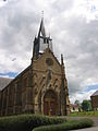
Saint-Marcel church

Chapelle de Giraumont
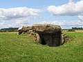
Allée couverte de Giraumont


Web links
Individual evidence
- ↑ Entry no. PA00078504 in the Base Mérimée of the French Ministry of Culture (French)
- ↑ Entry no. PA00078503 in the Base Mérimée of the French Ministry of Culture (French)
- ↑ Entry no. PA00078502 in the Base Mérimée of the French Ministry of Culture (French)