
Soraga di Fassa
| Soraga di Fassa | ||
|---|---|---|

|
|
|
| Country | Italy | |
| region | Trentino-South Tyrol | |
| province | Trento (TN) | |
| Coordinates | 46 ° 24 ' N , 11 ° 40' E | |
| height | 1207 m slm | |
| surface | 19 km² | |
| Residents | 683 (Dec. 31, 2019) | |
| Population density | 36 inhabitants / km² | |
| Post Code | 38030 | |
| prefix | 0462 | |
| ISTAT number | 022176 | |
| Patron saint | Santi Pietro e Paolo | |
| Website | www.comune.soraga.tn.it | |

|
||

Soraga di Fassa ( German obsolete: Überwasser , Ladin Soraga ) is an Italian commune ( comune ) with 683 inhabitants (as of December 31, 2019) in the province of Trento , Trentino-South Tyrol . Until February 2017 the municipality was only called Soraga, the Ladin name remained unchanged. The community belongs to the valley community Comun General de Fascia .
geography
Soraga di Fassa is located about 55 km north-northeast of Trento in the Fassa Valley on the Avisio at 1207 m slm . It is of the Dolomites mountains Marmolada in the east, rose garden in the northwest and the Latemar surrounded in the southwest. To the south of the village lies the Lago di Soraga reservoir, dammed up by the Avisio , which is also known as Lago di Pezzè. The neighboring municipalities are Moena and San Giovanni di Fassa and the two Bellunese municipalities Falcade and Rocca Pietore .
Administrative division
Soraga di Fassa still belongs to the Passo San Pellegrino lying fraction Fuchiade (lad. Fuciade or Fuciada )
photos

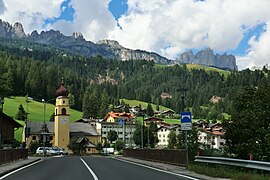
Soraga di Fassa with the Sassolungo Group in the background

Parish Church of Santi Pietro e Paolo
Soraga di Fassa with the rose garden in the background
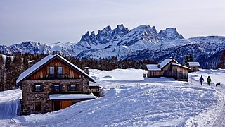
The Fuchiade fraction with the Pala group in the background


Web links
Individual evidence
- ↑ Statistiche demografiche ISTAT. Monthly population statistics of the Istituto Nazionale di Statistica , as of December 31 of 2019.
- ↑ Autonomous Region Trentino-South Tyrol Regional Law of February 23, 2017 No. 3 (German / Italian) accessed on April 24, 2018

Ala | Albiano | Aldeno | Altavalle | Altopiano della Vigolana | Amblar-Don | Andalo | Arco | Avio | Baselga di Piné | Bedollo | Besenello | Bieno | Bleggio Superiore | Bocenago | Bondone | Borgo Chiese | Borgo d'Anaunia | Borgo Lares | Borgo Valsugana | Brentonico | Bresimo | Caderzone Terme | Calceranica al Lago | Caldes | Caldonazzo | Calliano | Campitello di Fassa | Campodenno | Canal San Bovo | Canazei | Capriana | Carisolo | Carzano | Castel Condino | Castel Ivano | Castello Tesino | Castello-Molina di Fiemme | Castelnuovo | Cavalese | Cavareno | Cavedago | Cavedine | Cavizzana | Cembra Lisignago | Cimone | Cinte Tesino | Cis | Civezzano | Cles | Comano Terme | Commezzadura | Contà | Dambel | Denno | Dimaro Folgarida | Drena | Dro | Fai della Paganella | Fiavé | Florutz | Folgaria | Fornace | Garniga Terme | Repented | Giovo | Giustino | Grigno | Imer | Isera | Lavarone | Lavis | Ledro | Levico Terme | Livo | Lona-Lases | Lusern | Madruzzo | Malè | Massimeno | Mazzin | Mezzana | Mezzano | Mezzocorona | Mezzolombardo | Moena | Molveno | Mori | Nago-Torbole | Nogaredo | Nomi | Novaledo | Novella | Ospedaletto | Ossana | Palù del Fersina | Panchià | Peio | Pellizzano | Pelugo | Pergine Valsugana | Pieve Tesino | Pieve di Bono-Prezzo | Pinzolo | Pomarolo | Porte di Rendena | Predaia | Predazzo | Primiero San Martino di Castrozza | Rabbi | Riva del Garda | Romeno | Roncegno Terme | Ronchi Valsugana | Ronzo-Chienis | Ronzone | Rovereto | Roverè della Luna | Ruffrè-Mendola | Rumo | Sagron Mis | Samone | San Giovanni di Fassa | San Lorenzo Dorsino | San Michele all'Adige | Sant'Orsola Terme | Sanzeno | Sarnonico | Scurelle | Segonzano | Sella Giudicarie | Sfruz | Soraga di Fassa | Sover | Spiazzo | Spormaggiore | Sporminors | Stenico | Storo | Strembo | Telve | Telve di Sopra | Tenna | Tenno | Terragnolo | Terre d'Adige | Terzolas | Tesero | Tione di Trento | Sound | Torcegno | Trambileno | Tre Ville | Trento | Valdaone | Valfloriana | Vallarsa | Vallelaghi | Vermiglio | Vignola-Falesina | Villa Lagarina | Ville d'Anaunia | Ville di Fiemme | Volano | Ziano di Fiemme