
Urban development in Lübeck since 1864

The urban development of Lübeck since 1864 has been rapid. In just a few years the city has changed more than in centuries. In retrospect, four phases can be distinguished with transitions: From 1864 to the First World War, during the Weimar Republic to Palmarum in 1942, reconstruction and urban expansion until the 1970s and since then.
Starting point and conditions for change from 1864

The cityscape of Lübeck was characterized by great continuity until the beginning of the 19th century. The plot sizes and shapes ( parcels ) established in the Middle Ages with narrow width to the street and great depth, the lack of free space within the city walls for new buildings, a neighboring right that gave everyone the right to deviate from the conventional design as a reduction of their own property prevent, and last but not least, the economic weakness and backwardness of the city and its citizens after the Reformation prevented major changes for a long time. A lot of building activity in the Renaissance and Baroque periods was usually limited to reconstructions of brick Gothic substance instead of new buildings and only ensured changes in detail that did not fundamentally change the cityscape in the eyes of observers of the time. The reason for the irreversibility of the firewalls was the need for effective fire protection , which was recognized as early as the Middle Ages and which became the dogma of urban planning.
The changes became more significant by the end of the 18th century. Classicist conversions and new buildings (such as the Behnhaus ), which were enforced against the conservative neighbor law, encroach on several parcels, bring the first eaves-standing houses or at least one horizontal gable end through a facade facing the major streets. These buildings, however, only loosen up the cityscape without fundamentally changing it.

With this consistency, Lübeck differs significantly from the Hanseatic cities of Hamburg and Stettin , in which structural change due to industrialization and urbanization of Germany begins earlier and also leads to a significant change in the cityscape, but is similar to the majority of other cities in which structural change only occurs with the establishment of an empire begins. In 1871 there were only 8 cities with more than 100,000 inhabitants in the empire. In Lübeck, these changes are registered in the other Hanseatic cities and, especially in the non-profit society , the efforts are organized among the citizens to participate in the developments of the most advanced cities in Lübeck.

To do this, however, the weakening caused by the French occupation and internal and external resistance (especially Denmark) must first be overcome. The construction of the railway in 1851 - at least 20 years later than would have been possible without internal and external resistance - marks the start of change. In the 1860s the development accelerated: in 1864 Denmark left the Schleswig-Holstein politics through the Peace of Vienna and the connection to the traffic road to Hanover through the connection Büchen – Lüneburg, 1865 railway connection to Hamburg, 1866 connection to the North German Confederation and introduction of freedom of trade , joining the Zollverein in 1868 and unification in 1871
It was during this time that the gate lock in Lübeck was lifted in 1864. It obviously releases the brakes on the development of the suburbs and the reconstruction of the city within the city walls. While the city's population stagnated until the beginning of the 19th century and "only" increased by around 50% in the first half of the 19th century until the gate was closed and thus lagged significantly behind the sister cities of Hamburg and Bremen and even the Reich, From around 1867, it grew at a rapid rate from 34,600 to 1910 to 98,656 or 285%. Such population increases require living space, commercial and traffic areas. From this time on, new buildings and renovations within and outside the city walls dominate. In this phase, too, Lübeck does not belong to the top group of cities and still lags significantly behind Hamburg (321%), Bremen (297%), Stettin (304%) and above all Kiel (663%) in percentage terms in this phase Lübeck clearly outstripped the population. 33 of 40 cities in Germany that will become large cities during this time have a higher population growth rate than Lübeck.
From 1864 to the First World War
Developments in the city center

"City education" and "Wilhelminian large buildings" of historicism
In Lübeck's city center, the process of city building begins with the lifting of the gate lock . This term, derived from the City of London , denotes the concentration of central city functions, especially of the tertiary sector , especially in historic city centers. First of all, the functions offered in the center for its residents will be extended to residents outside the center. That has its limits. Some functions are being outsourced: Schools and churches in the suburbs are being built or enlarged very quickly. Where functions are perceived further in the center, they often require more space than the parcels of land that were shaped in the Middle Ages (and enclosed by firewalls) allow. Structural change in trade and administration also create independent factors for the increased space requirement. On the one hand, the housing needs of the growing population go beyond the boundaries of the medieval city center; on the other hand, a “segregation” of functions sets in in the city center itself, from fully supplying the resident population to performing central functions for the expanded city.
Numerous buildings document the process of city building. Almost all of them exceed the previous buildings in terms of area and height. The city built a great many buildings by its building director Adolf Schwiening himself - made possible by income from the new income tax . As historical buildings in the neo-Gothic style , they also dominate their surroundings stylistically: the reconstruction of the monastery complex of the Katharinenkloster for the Katharineum in Lübeck (city building directors Louis Martiny and Gustav Adolf Schwiening, 1874-1891, risalite and roof end destroyed in 1942, modernly replaced), the cathedral museum (1889–1893, destroyed in 1942), the main gym in Mühlenstraße (1891) and the courthouse in Burgstraße (1896). The corporations of the new empire also built the imperial post office on the market in a neo-Gothic style in the so-called postpalace style (1884, initially stylistically simplified in two steps after the First and Second World War, then finally demolished) and the first Reichsbank branch at Königstrasse 42 (1894/95, Design: Max Hasak )
Stylistically an exception among the new large buildings is the house of a private client, the Deutsche Lebensversicherungsgesellschaft, at Königstrasse No. 1 (1882), which was expanded again in 1907 in the so-called neo-renaissance style.
This style is also preferred by the smaller commercial and residential buildings, which are also showing a clear change. The houses Mühlenstrasse 1/3 and 5/7 (1866–1868, corner of Aegidienstraße ) can be named as examples of commercial buildings for the retail trade that conquered the city during this period . Right from the start, they offer shop windows on the ground floor - a new feature in the cityscape since the mid-19th century - and space for retailers, which in the older houses first required renovation. They are also significantly higher than the older houses in the immediate vicinity and each cover two parcels.
More and more houses are being built as rental apartments with self-contained apartments, whereas in the past every citizen lived in their own house. Even pure new residential buildings often protrude significantly above the older neighboring houses and show firewalls to the neighboring properties. In addition, they are often richly decorated with design elements such as bay windows and turrets that were alien to the previous cityscape. The entrance on Holstenstrasse keeps a faint memory of it alive.
In the Fischergrube and on the Untertrave , the new storage structures (including those of the Mann family ) are significantly larger than their predecessors.
The legal basis for these often structurally dominant and scale-breaking buildings was the lifting of the legal ban on changes in the law in 1854 and the building regulations of 1865 and 1881, which no longer set any height limits in streets with a minimum width of 11.50 m.
The construction and expansion of the gas and electricity works initially in the center is also part of this development of the center formation, even if such functions were very quickly pushed to the outskirts and thus the city functions were limited to service and trade.

Main gym around 1901

Cathedral Museum (1892)

Courthouse (1894/96)

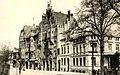
German Insurance Company (1882)

"Postpalast" (1882–1884)

Former Reichsbank branch (1894/95)
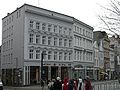
Mühlenstrasse office building (1866/68)

Speicher (left: Possehl 1871, right: Lienau 1870)


.jpg)
Trend reversal around 1900: Heimatschutz- und Jugendstil
Although Gustav Adolf Schwiening in particular intended to tie in with the Lübeck tradition of brick Gothic, the considerable changes in the cityscape caused by the new buildings were soon perceived very critically. A symbolic dispute was waged over the preservation of the lion pharmacy or the design of the castle gate . A facade competition in 1901 organized by the non-profit organization based on the example of many old towns was intended to encourage a return to tradition. B. with a facade width of 16 m specified a dimension that could not be implemented within the old parcels. The competition was won by Johannes Baltzer, who later became the city's building director .
His further work is also based on the endeavor to connect and adapt and shows, like the work of others in Lübeck during this time, echoes of homeland security , in particular the new building of the Ernestin School in Kleine Burgstrasse (1903/1904). The new construction of the Johanneum on the site of the St. John's monastery that was laid down for it is also one of the works of Baltzer. The Breite Strasse / Jakobikirchhof building complex and the Schmidt-Römhild publishing house on the corner of Mengstrasse / Fünfhausen or the Catholic journeyman's house on the Parade fit into the cityscape in a similar way . They all often harmonize better with the traditional than the buildings before 1900, even if they even pick up on the neo-Gothic like the Possehlhaus in 1909.
In addition, the new building of the theater (1906, architect Martin Dülfer ) as an important work of supraregional Art Nouveau or the bank on Kohlmarkt (1909/1910) modernized the cityscape.

Marienwerkhaus (1903/04) ( Wilhelm Glogner )

Ernestinenschule (1903/04)
City Hall (1904)

Theater (1906)

Johanneum (1906)

Publishing house Mengstraße (1907 / reconstruction 1943)
Possehl store (1909)

Bank on Kohlmarkt (1909)

Gym of the Katharineum (1910)

Hermberg'sches Haus (1910/11) (Architects: Hahn & Runge )

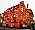
General local health insurance fund (1914) ( Alfred Redelstorff )


Olaf-Malzahn.jpg)

.JPG)


Development of the suburbs and the rural communities incorporated in 1913
Legal basis, development plan 1894
The legal basis for the development of the suburbs was laid a few years before the caesura assumed here, when the gate lock was lifted in 1864. On January 1, 1851, the city office took over the administration of the suburbs. The boundaries are determined in 1861 by the "Ordinance, the boundaries of the suburbs, and the application of the provisions that are not applicable to the conditions affected". Municipal development and supply obligations are taken over by the city in 1877.
The urban development plan initially does not lead to development plans. The very intensive planning activities of the city, especially by Peter Rehder , are initially more concerned with the planning of the Elbe-Lübeck Canal and the expansion of the Trave ( Trave corrections), but of course also indirectly influences urban development. Even the course of the new streets is not initially determined by the administration. All streets in the residential area in St. Jürgen , for example, are being built as private streets . The "Law for the Construction of Roads in the Lübeck Suburbs" from 1873 only determines road classes by defining generous road and sidewalk widths and a front garden zone. Development on the edge of a block is therefore initially prohibited. In 1883, the order for the development of a development plan was awarded to the Royal Prussian Land Surveyor Sponholz from Halle for the development of a development plan in which the latter drafted a plan for a ring road, particularly based on the model of Paris and Vienna, which was to run along the then development boundary of the suburbs. The development plan was only approved after 1894 under the Schwiening construction director. In some cases, it only stipulates what had already come about at least in part at this point in time.
Features of development
The development of the urban apron runs - typical for the urban development of this time - concentrically and radially ("wreath-like") around the city center along the historic country roads to Lübeck. The three suburbs ( St. Gertrud , St. Jürgen and St. Lorenz ) arise and take up most of the population growth and the resulting buildings.
The suburbs that arose in this way, however, lacked the typical metropolitan feel: 67% of all built-up properties in Lübeck in 1914 had a garden. (In comparison, it is 60% in Kiel, 39% in Stettin and only 34% in Cologne.) At least 14% of Lübeck's residents lived in a house. (In Hamburg it is only 4.8% at the same time, in Kiel 4.3% and in Stettin only 0.3%.) Almost 70% of all buildings in the suburbs only had a maximum of two floors and only 31% of all buildings served business purposes. The so-called housing rate , i.e. the average number of residents per house, was 9% lower than in most other cities in Germany with the exception of Bremen (Berlin 77%, Frankfurt 20%, Bremen 6%). So the suburbs were mostly residential cities. Only the suburb of St. Lorenz fell out of line in this respect. Industry grew here in the west of the city, here in the north around the barracks on Fackenburger Allee were more than half of the four-story buildings in the city.
The rural communities of Siems and Kücknitz, incorporated in 1913, deviate from the picture even more strongly from the development described . This is where the second phase of Lübeck's industrialization began, initiated after 1900 by the industrial association founded in 1889, leading to the settlement of several factories on the left bank of the Trave. Between 1900 and 1910, these municipalities had the largest percentage growth rates in terms of population: Siems 155.4% and Kücknitz - as the location of the blast furnace plant founded in 1905 - 829.5%. In absolute terms, it is of course less important. Both communities come together in 1910 to fewer than 2000 inhabitants and thus less than 2% of the population. Lübeck does not become an industrial metropolis even after 1900 and even in the rural communities. In 1913, however, 8,132 people were employed in industry, or around 13% of the resident population, after this proportion was just 6% in 1900.
The individual suburbs
On Roeckstrasse in the later suburb of St. Gertrud , numerous summer houses of the wealthy Lübeck families were built before the gates were lifted at the end of the 18th century and in the first half of the 19th century . Thomas Mann was born in one of them . These summer houses were followed by numerous villas at the end of the 19th century, emphasized luxuriously from around the turn of the century, especially around the city park, where two palais-like residential pens of the von Borries-Stift for “women and virgins from the educated classes of Lübeck” and the Heinrich Gaedertz Foundation for "gentlemen from educated classes" were built. St. Gertrud thus became the elegant suburb.
However, the so-called village , a small-scale development around Paulstrasse between Roeckstrasse and today's court house , whose forerunners were created in connection with the prohibition of inner-city pig farming, such as Bäckerstrasse in St. Jürgen in 1583, has been preserved, but not through there posh buildings had been replaced. The Heiligen-Geist-Kamp, whose name recalls that the lands around were previously owned by Lübeck's oldest foundation, the Heiligen-Geist-Hospital , and that most of them still stand today as heritable building rights, only became a building limit in the period after the First World War achieved in the 1930s . In the east, the development ended around the St. Gertrud Church, built in 1910, next to which the previously unrealized Ringstrasse should run.
Even further to the northeast, within the district, lies the Burgtorfriedhof , which was expanded on Sandberg in 1915 to include the cemetery of honor planned by Harry Maasz .

The construction of the Elbe-Lübeck Canal and the associated planning - finally also the development plan 1894 - determine the development of the south (east) suburb of St. Jürgen in particular . The industrial area around the former St. Petri brickworks (later Gasworks I on Geniner Straße) crystallizes in its (future) course and is laid down in the 1894 development plan. The canal and the development plan later determine the location of an industrial area in the east of the city directly on the canal near the Klughafen, named after Mayor Heinrich Klug . By following the course of the old moat in the south, the canal continues it and defines the respectful distance between the suburb and the city center, which prevents the city-building processes from jumping into this area of the city. The new quarter around Stresemannstrasse is therefore set as a residential area in the development plan in 1894. In the east, the construction of the Falkendamm enables the new construction of the district north of Moltkestrasse between the Canal and Wakenitz , in which block perimeter development is also being built in St. Jürgen. These new construction activities encompassed the old suburban development around Bäckerstraße, which had already been built for reasons of hygiene as part of the ban on inner-city pig fattening. In St. Jürgen, too, the public sector acts as a property developer on a large scale. In addition to schools, as in other parts of the city, the new water art , a modern waterworks in place of the medieval water art located on today's Hüxterdamm , and above all between 1885 and 1887 the general hospital (later the municipal hospital, today the Sanaklinik) were built. In 1909–1912, the Strecknitz sanatorium was built even further south , from which the university hospital developed.

Hanseatic LVA (1905/06)

In the west of the city in the suburb of St. Lorenz , the train station (1908, architect: Fritz Klingholz ) determines the development. In its vicinity, large buildings such as the administration building of the Lübeck-Büchener Railway are being built on the Bahnhofsplatz in block perimeter development . The first train station in the ramparts continues this and establishes the distance between the new suburb and the city center. The railway tracks also attract trade and industry. This is where the first "modern" workers' apartments in Lübeck are being built, primarily between Moislinger Allee and the railway tracks in St. Lorenz-Süd and in the districts around Schwartauer Allee in St. Lorenz-Nord, which will allow people to move to Lübeck or move out of the aisles and courtyards in the old town. The new rail connection to Hamburg ultimately even divides the St. Lorenz district into two differently developing areas. The large new barracks on Fackenburger Allee were financed by the North German Confederation in 1868 .

New main station (1908)

LBE administration building


Traffic in the city center and suburbs
For the growing traffic (1906 there were only 21 cars in Lübeck) the widening of the streets in the inner city was planned. A law from 1895 to relocate the building lines and a program from 1905 served to implement such plans. In particular, Holstenstrasse was widened for the first time .
Another connection from the old town to the ramparts was created (in place of the Mats ferry) in 1890 by the swing bridge. From then on to St. Lorenz there was only a very simple bascule bridge until the Marienbrücke was built. This created a second connection to the west and north-west.

In the east, the new Moltke Bridge was ahead of its time. It was built in the hope of building on the area beyond the Wakenitz, some of which he had acquired, by the building counselor Ferdinand Wallbrecht, who had moved from Hanover, at his expense in 1892/93 and initially made it possible to visit the German-Nordic trade and industry exhibition east of the Wakenitz .
Only small sections of the ring road plan were implemented: the Hansering to the west, the St.-Jürgen-Ring to the south and the Marliring to the east. The names of the western and eastern sections are reminiscent of these plans. Only the section of the St.-Jürgen-Ring in the south was included in the later planning. The plan of the ring connections was not implemented because at that time the pressure from road traffic was not great enough, while on the other hand shipping would have been severely disrupted by the bridges that these ring roads make in Lübeck necessary. The freight station in the north of the Hansering and the former railway line along Possehlstrasse / Berliner Allee also opposed such a ring.
The connection to the new industrial areas on the other side of the Trave was taken over by the first Herrenbrücke in place of a ferry from 1902 , which was designed as a double swing bridge so as not to obstruct shipping.
Conclusion of the developments up to 1918
The urban development of the first 40 years shows parallels and differences to other German cities. A wreath of suburbs concentrically developing along the old country roads around the old city is a standard pattern of urban development. A peculiarity, on the other hand, is the wide ring of the Trave and Wallgraben on one side and the Kanal and Wakenitz on the other, which lies between the city and the suburbs and is perpetuated by new transport systems such as the railway and the canal. It has advantages and disadvantages for the urban development opportunities. On the one hand, it receives the view of the "city crown" of the landmark- like Seven Towers of the five main churches in Lübeck, which has been vaunted for centuries , on the other hand, the barrier deprives the center of an area for outer city expansion and relief from the city functions, even if a part of the entire area, the area in front of the Holsten Gate as a city extension kept coming up in the following years.
The changes to the cityscape in the city center over the 44 years between 1864 and 1918 are difficult to understand today. Many of the buildings from these years were destroyed in 1942 or later demolished or rebuilt beyond recognition. The remnants even from the period before 1900 fit in better with the older buildings against the contrast of the buildings after 1945 than would probably be perceived without the contrast.
The picture is somewhat different in the suburbs. Many private buildings of the time have been preserved here and are now receiving more intensive and cheaper appreciation. Here, too, the public buildings are handled differently: For example, the barracks in Fackenburger Allee was demolished in 1976, and the last fragment of the General Hospital was only recently demolished in 2006 with the city pharmacy.

Katharineum around 1900

Katharineum today


During the Weimar Republic and until Palmarum 1942
Downtown and old suburbs
In the few years of the Weimar Republic , developments from the time before the First World War continued. The population of the whole city grew again from 117,173 inhabitants in 1919 to 133,021 in 1933.
Also the new buildings of this time, in particular the city library designed by senior building officer Friedrich Wilhelm Virck in Hundestrasse (1926/27), the new department store of the consumer association in Sandstrasse 24–28 on Klingenberg (1929) and the union building in Dr.-Julius-Leber -Straße (1930), modernize the cityscape. The city library in particular is an example of North German brick expressionism .
The renovation of the old building has also started. As part of a program to “improve the old town” under the city planning officer Otto Hespeler , the view began to prevail that the courtyards and corridors should be gutted, with exceptions, because hygienic conditions and “light, air and sun” - the buzzwords of urban planning for many Decades - could not be brought into the old town. However, Hespeler also stands for efforts towards homeland security architecture . Preserved to this day, air raid shelters like the replica of a former tower of the mill gate were also built in the homeland security style "for reasons of better camouflage".
Thoughts on city extensions began in front of the Holsten Gate and / or the Burgtor . Example of the first implementation on the Holsten Gate is the building of the new branch of the Reichsbank , on the other side of the Holsten place to the 700th anniversary erected Holstentorhalle . The Handelshof (1924) was built at the station as an outstanding example of clinker expressionism, which closes the station square to the south.
The mediatization of Lübeck by the Greater Hamburg Law also led to the abolition of administrative unity in the area of building in Lübeck; the building administration is now separated into the municipal building administration and the Prussian State Building Office. Under the National Socialists, an administrative forum in front of the castle gate was planned, but not implemented.

Handelshof (Zauleck and Hormann, Hamburg 1924)

City Library (Virck 1927)

Falkenstrasse residential building with a passage to the Reiherstieg (from Ladiges 1928)

Department store of the consumer association (Runge + Lenschow 1929)

Union House (Runge + Lenschow 1930)


.JPG)


Inner city traffic
The traffic in the city center increased significantly. On May 15, 1927, a system of one-way streets was introduced in Lübeck . The Königstrasse took the traffic in the south-north direction, the Breite Strasse the traffic in the north-south direction. In a west-east direction, traffic drove over Holstenstrasse, Kohlmarkt and Wahmstrasse . In an east-west direction, oncoming traffic drove through Hüxstraße , Markt (under the town hall arcades!) And Braunstraße . The tram could not be included in this one-way street regulation, because rails were only in the Breiten Straße and Holstenstraße and of course could not even theoretically be laid under the Rathausarkaden (above the vaults of the Germanist cellar ), so that the one-way street regulations did not cause the "traffic chaos" completely fixed. Based on these experiences, plans later developed to (further) widen the inner city streets to create an east-west connection, which uses the medieval “T-structure” (continuous in north-south direction, but capped in west-east direction) of the Turn inner city traffic into a traffic intersection. The introduction of city buses in north-south direction on February 26, 1935 and the construction of the Horst-Wessel Bridge (today: Rehder Bridge ) as an extension of Wahmstraße are among the efforts to solve this problem.
Settlements
Outside the city center, development of the three suburbs was essentially complete before World War I. With the settlements, a new chapter in urban development began, which had a forerunner in the Heimstättensiedlung (Heimstättensiedlung) proposed by the later Senator Georg Kalkbrenner in today's Buntekuh district , which was built before the First World War. The urban planning model of the settlements (Gärtnergasse, Karlshof, Moisling , Dornbreite, Brandenbaum) was that of the garden suburbs , turning away from the deterring compact cities of the Wilhelminian era with their traffic problems, which were already becoming clear at that time, lack of nature ("light, air, sun" ) and also constantly increasing land prices. In addition, the settlement movement had a strong motive, partly social welfare, partly cooperative self-organization, especially of the workers. Typhouses and simple construction should reduce building prices. Large plots of land with their kitchen gardens should create opportunities for self-sufficiency. The city also supported these movements through new legal institutes such as the long lease , and Lübeck's gardening department manager Harry Maasz consistently followed the principle of garden socialism and thus the idea of the green city . After the lost war, it was no longer just a matter of caring for the workers, but also of the returning soldiers.
General settlement plan 1928
The general settlement plan of May 15, 1928 is already at the end of the settlement development. In terms of urban planning, it also follows the ideal of the so-called ribbon city , which seeks to counter the “wild growth” of the concentric suburbs and the garden suburbs oriented towards a center with a city without a center or at least with a not so clearly defined center. Advantages of the ribbon city over a concentric city are seen in the equalization and unbundling of the traffic aimed at the center and, similar to the street village, in the short distances to work and nature. According to the plan, the ribbon was to form the Trave, which would have been lined by commercial areas (seaport near Gothmund, industrial area on Dummersdorfer Ufer ). The population development up to 420,000 presented here even exceeded the reality of the post-war period, in which the 250,000 mark was not exceeded.
Reconstruction and urban expansion in the post-war period up to the 1960s
Bomb damage to Palmarum in 1942 and reconstruction plans
On 28/29 March 1942 Lübeck was the first German city to be covered by the air raid on Lübeck with an area bombing by the Royal Air Force , in accordance with the British Area Bombing Directive , which had recently been issued . The damage was concentrated on the western part of the old town island and the area around the train station in St. Lorenz-Süd . Compared to all other major German cities (over 100,000 inhabitants) the damage was low in terms of percentage. On the other hand, great damage was caused on the old town island. Of the large churches, only the Jakobikirche remained undamaged, the Aegidienkirche suffered slight damage. Marienkirche , Dom and Petrikirche had even partially collapsed and the founding quarter was completely destroyed except for the lowest part of Mengstrasse .
The reconstruction planning began during the war. Hans Pieper received a secret order from Mayor Otto-Heinrich Drechsler just two weeks after the attack. In the same year Carl Mühlenpfordt was commissioned by the merchants . The results of these plans were published immediately after the war. Both wanted to solve the traffic problems known from the pre-war period during the reconstruction. Both plans therefore have in common a new east-west connection through Holstenstrasse and Wahmstrasse with a widening to 22 meters, whereby these proposals were favored by the almost complete destruction on both sides of two thirds of Holstenstrasse and the upper part of Wahmstrasse. Both wanted the so-called Beckergrubenbrücke, which was supposed to connect the Beckergrube via Trave and Stadtgraben with the station district as a newly created city extension and which was only finally rejected by the Music and Congress Hall (1994). Both were equally unanimous in calling for a block to be gutted, although criticism of such proposals today often overlooks the fact that the living conditions in the corridors were apparently terrifying in the Weimar Republic. Even if both planners made very radical proposals from today's perspective, the post-war period was even more radical in some respects. All planning and also the reconstruction practice unreservedly affirm the process of city building and subordinate the preservation of the old to it.
Reconstruction plan 1950 and practice of reconstruction
The legal basis was the Schleswig-Holstein construction law of May 21, 1949 (GVOBl. Für Schl.-H. 1949, 93 ff). With the formal reallocation (in addition to the private 'voluntary' reallocation), this law created the means of adapting the structure of the parcels and the building lines. On this basis, the inner courtyards in the city center were reallocated . The inner block courtyards united the rear open spaces of the plots of land on some street blocks owned by the city, each into a plot of land with access from the public road. Since then, the city has made these areas available to the direct neighbors for rear delivery and parking.
Developments on the outskirts
See an example of the ERP program 10,000 refugee apartments and duplex houses
Urban renewal (1970s) and urban redevelopment (1980s)
At the beginning of the 1970s , on the legal basis of the Urban Development Promotion Act of 1971, a complete rethink in dealing with the old town began. Voices denouncing the destruction of the historic cityscape by the modernization that has been carried out and the parallel decay of the residential areas on the inner city island (especially "Segeberger Appell") are now increasingly being heard in politics and administration and over the course of the decade lead to the fundamental decisions that still apply today dealing with the inner city island. In the so-called S-4 report of the city planning office of the city of Lübeck, the guiding ideas, which were later decided by the citizenship resolution of June 12, 1975 in a slightly modified form, are formulated particularly succinctly:
1. The Lübeck old town is to be preserved as a cultural monument in its entirety (Stadtdenkmal ). This means not only the preservation and renewal of the comparatively small number of listed buildings, but also the revitalization of those quarters which, through their scale and shape, shape the entire city center.
2. The Lübeck city center is to be converted into residential areas wherever there is historical building stock, which will be equipped with the necessary technical and social infrastructure.
3. The development and expansion of city functions should be limited to those areas which already fulfill this function today and which, because of their deviation from the historical basic pattern, do not shape the cityscape anyway.
Conflicting goals should be resolved in the order of the guiding principles listed here. The process of further city building on the old town island should therefore be stopped. It was believed that this process could not continue without further destruction of the cityscape and impairment of the island's residential functions. City functions should be relocated from the island and perceived outside of it. In 1979, a complete cadastre-referenced cityscape recording with the connected, photometrically recorded facade views of all buildings was created and published as a basis for work, sorted according to the individual building blocks of the old town island.
Further work on the concept culminates in the 1982 design and maintenance statutes, the inner city traffic concept in 1985 and the updated master plan in 1988.
Effects of German reunification
The reunification of Germany is for Luebeck with an end to the situation of the border town on the Iron Curtain connected. On the one hand, this leads to a brief economic upswing and, on the other hand, to traffic pollution in the city center, which exposes its capacity to heavy loads due to the lack of infrastructure. At the same time, however, the accustomed zone edge funding is no longer available . It creates new neighborhoods and commercial areas in Mecklenburg affluent suburbs of the city, with a new funding gap are favored. In this context, Lübeck's municipal policy recognizes its mistake in strengthening the surrounding communities with suburban character such as Bad Schwartau , Groß Grönau and Stockelsdorf in their metropolitan area by failing to designate further new residential areas, especially for home construction, since the early 1970s . In the 1990s, she decided on one of the largest urban development projects in Germany at this time with the new university district in St. Jürgen , in order to counteract the loss of more families to the surrounding areas in Holstein and Mecklenburg.
present
Planning principles
The goals of future urban development or a local sustainability strategy in the sense of a Local Agenda 21 are not defined. The mission statement process was terminated in 2000, and the Possehl Foundation also succeeded in attempting to reconnect with the mission statement process in 2002, which did not produce the desired result. An urban development plan or district development plans are also not available.
Lübeck is subject to the 2004 regional plan for planning area II of the state of Schleswig-Holstein , which deals with the planning area of the independent city and the district of Ostholstein . The districts of Lauenburg and Stormarn , which adjoin to the south and west, are included in the Hamburg area planning of the regional plan for planning area I - Schleswig-Holstein South 1998, which roughly corresponds to the metropolitan region of Hamburg in Schleswig-Holstein. The regional plans are based on the Schleswig-Holstein State Spatial Planning Plan 1998 . Beyond the state border with Mecklenburg-Western Pomerania , the responsibility for regional planning lies with the Office for Spatial Planning and Regional Planning West Mecklenburg in Schwerin . A collaboration in the so-called HOLM region (Holstein-Lübeck-Mecklenburg) was suggested in the 1990s, but it did not come to fruition. This clearly shows the situation of the border town, which is not only complicated in terms of planning law, in the structure of Schleswig-Holstein's state politics.
Lübeck also belongs to the Interreg III B area of the European region Fehmarnbelt , further consisting of the Ostholstein district and the Danish Storstrøms office , which includes the islands of Lolland , Falster and the southern part of Zealand . This region is to grow closer together in the future through the fixed link across the Fehmarnbelt, which is being pursued by politics .
swell
- ↑ On continuity and changes during this time in detail Hasse 1975 and Brix 1981. Brix p. 246 shows the description of Senator Buddenbrock's move to the fishing pit and the depiction of his motifs and those of his successor Consul Hagenström in the Beckgrube by Thomas Mann .
- ↑ Cf. Kahns 1956 for a comparison of Lübeck with Hamburg and Stettin, also with regard to economic data. General information on urbanization Reulecke 1985, pp. 68ff. and table appendix
- ↑ Calculated according to the information in the table by Reulecke 1985, p. 203 Table 3
- ↑ Comprehensive on the processes of city building in Lübeck from the perspective of the early 1980s Rühsen 1982. As early as 1921, however, Reimpell rightly emphasized the limits of this process in Lübeck compared to other cities such as Hamburg, Stettin or Kiel.
- ↑ On these buildings Brix 1975, p. 33ff., Ders. 1988, p. 246ff. and Matthias 1992, 182ff.
- ^ To the facade competitions Brix 1985.
- ^ Andresen 1975, Schefftel 2005, 343ff.
- ↑ Cf. on the ambiguous process of this new building Brix 1975, p. 34f .: The demolition of the Bernstorff curia that had previously existed there met with resistance from Lübeck architects who wanted to preserve even more of the old. However, Baltzer's new building is widely regarded as a successful integration into urban traditions. A very positive assessment from today's perspective by Matthias 1992, p. 185ff.
- ^ Matthias 1992, 190ff.
- ↑ To all buildings after 1900 Matthias 1992
- ↑ In detail on this and the consequences to this day Guhr 1988
- ↑ Pieper 1933, p. 115 and Kremmer 1957, p. 109ff.
- ↑ All figures from Reimpell 1921 with further references. For more recent research cf. Ibs 2005 with comprehensive evidence.
- ↑ Kahns 1956, 126 and Arndt 1982
- ↑ To the whole Hundt 2003
- ^ Matthias 1984, 1986, 1990 and Scheftel 2005
- ↑ Hespeler 1936, p. 99: "Basically the good courtyards and corridors should be preserved."
- ↑ To the following impressive Saager 1986
- ↑ On the establishment of Heimstätten Gesellschaft mbH cf. Tailor 1970
- ↑ On the beginnings of the cooperative building associations cf. Pious 1955
- ↑ To the general settlement plan Kremmer 1957, p. 110 ff.
- ↑ On the conception of the Bandstadt and its (minor) influence on urban planning in Germany, cf. Miss 2000
- ↑ A comparative compilation in Beyme 1987, p. 38ff. assumes a degree of destruction of 20% and only shows lower damage for Erfurt , Halle and Hindenburg and the same degree of destruction for Solingen ( Hamburg in this combination e.g. 54%, Bremen 51%, Kiel 44%, Rostock 40%) .
- ↑ On this in detail Fischer 1992
- ↑ Up until the 1970s , 30% of the still preserved corridors had no toilet and 62% had no shower or bath (evidence from Rühsen 1982, p. 161).
- ↑ City Planning Office Lübeck 1973, on the history of this report Killisch 1980
- ↑ Regarding the resolution and its update, Stimmann 1990, p. 16 with the wording of the (defused) citizenship resolution in footnote 4
literature
- Hans-Jochen Arndt: Structures of the Lübeck Economy in Past and Present , MGG 1982, pp. 133–145.
- Hans-Günther Andresen: Heimatschutzarchitektur in Lübeck - a forgotten attempt to deal appropriately with a city monument . In: Michael Brix (Ed.): Lübeck. The old town as a monument . 1975, ISBN 3-7879-0082-9 , pp. 47-65.
- Klaus von Beyme: The reconstruction. Architecture and urban development policy in both German states . Piper, Munich 1987, ISBN 3-492-03162-5
- Michael Brix : Breaking into the structure of Lübeck's old town as a monument preservation problem: the early days and reconstruction after 1945 . In: ders. (Ed.): Lübeck. The old town as a monument . 1975, pp. 25-46.
- Michael Brix: Facade competitions. A program to maintain the cityscape around 1900 . In: Meckseper / Siebenmorgen: The old city: monument or living space? . 1985, ISBN 3-525-33508-3 , pp. 67-89.
- Michael Brix: Nuremberg and Lübeck in the 19th century: preservation of monuments, maintenance of the cityscape, urban redevelopment. (= Studies on 19th Century Art 44) Munich: Prestel 1981, ISBN 3-7913-0526-3
- Citizens 'Initiative Rettet Lübeck (BIRL) eV: Citizens' news. Self-published magazine, Lübeck.
- Gerhard Fehl: Garden City and Band City. Competing models in German urban development . In: Die alte Stadt 27 (2000), pp. 48–67.
- Manfred Finke: 116 times Lübeck. Monument protection - renovation - new architecture. 25 years of dealing with a city monument. Lübeck: Schmidt-Römhild 2000, ISBN 3-7950-1239-2
- Manfred Finke: Unesco world cultural heritage old town of Lübeck: city monument of the Hanseatic era. Wachholtz, Neumünster 2006, ISBN 3-529-01335-8 .
- Friedhelm Fischer: Lübeck: A gem in the economic slipstream . In: Klaus von Beyme (ed.): New cities from ruins. German post-war urban development . 1992, pp. 98-116.
- Franz Fromme: From the beginnings of the settlement movement in Lübeck . In: Der Wagen 1955, pp. 103-108.
- Klaus J. Groth: World Heritage Lübeck - Listed Houses . Schmidt-Römhild, Lübeck 1998, ISBN 3-7950-1231-7
- Hanseatic City of Lübeck: Master plan inner city - update 1988 . Series "Lübeck plans and builds" issue 13, Lübeck 1989, ISSN 0933-193X
- Hanseatic City of Lübeck: Monument plan old town . Series Monument Preservation in Lübeck 3, Schmidt-Römhild, Lübeck 2000, ISBN 3-7950-1238-4
- Max Hasse : Preservation of monuments in Lübeck. 19th century . 1975
- Otto Hespeler: Improvement of the old town in Lübeck . In: Der Wagen 1936, pp. 99–106.
- Jürgen H. Ibs: Population- historical aspects of the Lübeck rural communities in the age of industrialization . In: The memory of the Hanseatic city of Lübeck. Festschrift for Antjekathrin Graßmann on his 65th birthday , Lübeck 2005, ISBN 3-7950-5555-5 , pp. 221-230
- Renate Kastorff-Viehmann: Harry Maasz, garden architect, garden writer , garden poet - gardens in Lübeck . 1998, ISBN 3-88474-676-6
- Winfried Killisch: Sustainable renewal of a historic city center . In: Reports on German regional studies 54 (1980), 165–210
- Siegfried Kremmer: Lübeck's urban planning . In: Der Wagen 1957, pp. 106–121.
- C. Lembke: Lübeck on the water. In: Der Wagen 1954, pp. 119-134.
- Klaus Matthias: Large buildings in downtown Lübeck after 1900. From overcoming historicism to Art Nouveau . In: Der Wagen 1992, pp. 182–205.
- Hans Pieper: Lübeck. Urban planning studies for the reconstruction of a historical German city . Lübeck 1946 (edited by Dr. Ing.Klaus Pieper)
- E. Reimpell: On the settlement geography of Lübeck , MGG 1921, pp. 11–37.
- Hans-Werner Rühsen: Elements of city building in Lübeck . In: Mitteilungen der Geographische Gesellschaft zu Lübeck 55 (1982), pp. 147–168.
- Wolf-Rüdiger Saager: Fifty years of city buses in Lübeck . In: Der Wagen 1986, 111–120
- Michael Scheftel: Does Lübeck architecture exist? Thoughts on tradition and progress in a long architectural history . In: ZLG 85 (2005), pp. 331-348.
- Gerhard Schneider: The Heimstätten Gesellschaft mbH in Lübeck. Becoming and working . in: Der Wagen 1970, pp. 93-104.
- City planning office Lübeck: S-4. Target discussion and alternative models for the redevelopment of Lübeck city center . Lübeck 1973
- Hans Stimmann: Plans in ruins - 40 years of reconstruction planning 1949 - 1989 . In: Der Wagen 1990, pp. 15–32.
- Housing credit institution of the State of Schleswig-Holstein in cooperation with the City Planning Office Lübeck: Cityscape of the old town island , I. Update Kiel / Lübeck 1990
- Jan Zimmermann: Lübeck. Photographs from yesterday and today . Gudensberg-Gleichen 2002
Web links
- Architecture Forum Lübeck
- UNESCO site on the world cultural heritage of Lübeck Old Town with links to ultimately positive reasons for the decision and rejection of the application at the first attempt
- Documentation of the mission statement process, which ended without result in 2000, with remarkable content on urban planning
- Regional plan 2004 for planning area II (Schleswig-Holstein Ost = district of Ostholstein and urban district of Lübeck) (PDF; 595 kB)