
Book at the forest
| coat of arms | Germany map | |
|---|---|---|

|
Coordinates: 49 ° 20 ' N , 10 ° 20' E |
|
| Basic data | ||
| State : | Bavaria | |
| Administrative region : | Middle Franconia | |
| County : | Ansbach | |
| Management Community : | Schillingsfürst | |
| Height : | 465 m above sea level NHN | |
| Area : | 26.44 km 2 | |
| Residents: | 1039 (Dec. 31, 2019) | |
| Population density : | 39 inhabitants per km 2 | |
| Postal code : | 91592 | |
| Primaries : | 09867, 09868 | |
| License plate : | AN , DKB, FEU, ROT | |
| Community key : | 09 5 71 125 | |
| Community structure: | 12 parts of the community | |
| Address of the municipal administration: |
Schulstrasse 3 91592 Buch am Wald |
|
| Website : | ||
| First Mayor : | Friedrich Priester ( Buch am Wald voter group ) | |
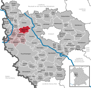
| Location of the municipality of Buch am Wald in the district of Ansbach | ||
  |
||


Buch am Wald (officially: Buch a.Wald ) is a municipality in the Central Franconian district of Ansbach and a member of the Schillingsfürst administrative community .
geography
Geographical location
The community is located in the Frankenhöhe Nature Park . Neighboring communities are (starting in the north clockwise): Geslau , Leutershausen , Schillingsfürst and Gebsattel .
Community structure
There are twelve officially named municipal parts (the type of settlement is given in brackets ):
|
|
The four wastelands Birkenmühle , Kleinmühle , Obermühle and Rufenmühle are not officially designated parts of the municipality.
history
The first reliable evidence for the place comes from the year 1335. Here the place is called "book". The place name is derived from a field name of the same name, which pointed to a beech forest that existed at that time . Evidence from the years 1255 and 1261 cannot be safely assigned to this location. Since 1761, the current form "Book am Wald" has been documented.
In the 16-point report of the Brandenburg-Ansbach Oberamt Colmberg from 1608, 48 teams are recorded for Buch am Wald, all of which had the Kastenamt Colmberg as landlord . The High Court exercised the Vogtamt Colmberg . After the Thirty Years' War, the place became the new home of around 80 religious refugees who had to leave their Upper and Lower Austrian homeland because of their evangelical confession. In the 16-point report of the Colmberg Oberamt from 1681 49 teams are listed for Buch am Wald.
Towards the end of the 18th century there were 60 estates in Buch am Wald (2 half sheep farms, 4 estates, 1 smith estate, 13 Köblergüter , 11 Söldengütlein , 20 half Köblergüter, 1 Wirts-Köblergut, 1 Köblergut with baking right, 1 Söldengütlein with baking right, 1 Söldengütlein with brandy wine tavern, 1 Söldengut with brick kiln, 2 mills; the donations of a semi-estate with blacksmithing rights went to the parish of Colmberg, the donations of the parish widdum to the parish of Buch). The high court, the village and community rulership and the lordship over all properties continued to exercise the Vogtamt Colmberg. In addition to the property, there was also the parish church and communal buildings (school house, shepherd's house, break house ).
During border adjustments in 1796, the place was left to Prussia by the Principality of Hohenlohe and thus part of the Principality of Ansbach acquired by Prussia in 1792 . From 1797 to 1808 the place was subordinate to the Justice Office Leutershausen and Chamber Office Colmberg .
In 1806, Buch an Wald came to the Kingdom of Bavaria . As part of the municipal edict , the Buch am Wald tax district was formed in 1808 , to which Berbersbach , Birkenmühle , Buch am Wald, Hagenau , Kleinmühle , Leimbachsmühle , Morlitzhaben , Obermühle and Rufenmühle belonged. The rural community Buch am Wald was founded in 1810 and was congruent with the tax district. It was subject to the Leutershausen Regional Court in administration and jurisdiction and to the Colmberg Rent Office for financial administration . With the second community edict (1818) the division into
- Rural community Buch am Wald with Kleinmühle and Obermühle;
- Rural community of Hagenau with Berbersbach, Birkenmühle, Leimbachsmühle, Morlitz winds and Rufenmühle.
From 1862 to 1879, Buch am Wald was administered by the Ansbach district office , and from 1880 by the Rothenburg ob der Tauber district office (renamed the Rothenburg ob der Tauber district in 1938 ). The jurisdiction remained with the district court Leutershausen until 1879, since 1880 district court Rothenburg ob der Tauber . The financial management was taken over in 1880 by Rentamt Rothenburg ob der Tauber (renamed Finanzamt Rothenburg ob der Tauber in 1920 ). The community originally had an area of 6,500 km².
Incorporations
On January 1, 1974, the formerly politically independent communities of Hagenau and Gastenfelden were incorporated into Buch am Wald.
Population development
In the period from 1988 to 2018, the population increased from 865 to 1025 by 160 inhabitants or by 18.5%.
Buch am Wald community
| year | 1987 | 2005 | 2007 | 2008 | 2009 | 2010 | 2011 | 2012 | 2013 | 2014 | 2015 | 2016 | 2017 |
|---|---|---|---|---|---|---|---|---|---|---|---|---|---|
| Residents | 858 | 970 | 975 | 953 | 928 | 929 | 969 | 974 | 993 | 990 | 1002 | 1003 | 1011 |
| Houses | 231 | 290 | 293 | 294 | 300 | 303 | |||||||
| source |
Part of the municipality of Buch am Wald with Kleinmühle and Obermühle (= municipality of Buch am Wald until the regional reform)
| year | 1818 | 1840 | 1852 | 1855 | 1861 | 1867 | 1871 | 1875 | 1880 | 1885 | 1890 | 1895 | 1900 | 1905 | 1910 | 1919 | 1925 | 1933 | 1939 | 1946 | 1950 | 1952 | 1961 | 1970 | 1987 |
|---|---|---|---|---|---|---|---|---|---|---|---|---|---|---|---|---|---|---|---|---|---|---|---|---|---|
| Residents | 305 | 352 | 366 | 364 | 383 | 390 | 385 | 390 | 402 | 374 | 386 | 379 | 395 | 397 | 407 | 394 | 358 | 364 | 359 | 481 | 485 | 408 | 361 | 363 | 383 |
| Houses | 81 | 68 | 80 | 82 | 83 | 77 | 85 | 83 | 120 | ||||||||||||||||
| source |
politics
badges and flags
Buch am Wald has had its own coat of arms since 1987.
|
|
Blazon : “Above a silver shield base , inside a silver armored, red-tongued, looking, striding black lion , square of silver and black. In 1: a sloping red beech leaf; in 2: three obliquely left golden beechnuts on golden stems; in 3: a fallen golden beech leaf lying obliquely to the left; in 4: an inclined, fallen red beech leaf. " |
| Justification of the coat of arms: The three numbers of beech leaves and beech nuts represent the three former communities of Buch a. Wald, Hagenau and Gastenfelden. They also stand for the place name. The lion is taken from the coat of arms of the princes of Hohenlohe , who can be traced as rulers in the municipality in the Middle Ages. In the 14th century, part of their property came to the burgraves of Nuremberg , reminiscent of the Zollernvierung of silver and black . The colors red and silver indicate the monasteries and patricians from the imperial city of Rothenburg , who were the landlords in the municipality. |
Buch am Wald also carries a red and yellow municipal flag.
Architectural monuments
Economy and Infrastructure
The community is a member of the Romantic Franconian Tourist Association.
traffic
The district road AN 5 leads to Hagenau to state road 2249 or to Hürbel . Communal roads lead to Frommetsfelden , Jochsberg , Lauterbach and Morlitzhaben .
Sons and daughters
- Friedrich Hessing , from 1913 Ritter von Hessing (1838–1918), pioneer in the field of orthopedic technology
literature
- Johann Kaspar Bundschuh : book . In: Geographical Statistical-Topographical Lexicon of Franconia . tape 1 : A-egg . Verlag der Stettinische Buchhandlung, Ulm 1799, DNB 790364298 , OCLC 833753073 , Sp. 464 ( digitized version ).
- Johann Kaspar Bundschuh : Book at the forest . In: Geographical Statistical-Topographical Lexicon of Franconia . tape 6 : V-Z . Verlag der Stettinische Buchhandlung, Ulm 1804, DNB 790364328 , OCLC 833753116 , Sp. 661 ( digitized version ).
- Manfred Jehle: Ansbach: the margravial chief offices Ansbach, Colmberg-Leutershausen, Windsbach, the Nuremberg nursing office Lichtenau and the Deutschordensamt (Wolframs-) Eschenbach (= historical atlas of Bavaria, part Franconia . I, 35). tape 2 . Commission for Bavarian State History, Munich 2009, ISBN 978-3-7696-6856-8 , p. 843-844, 982-983 .
- Eberhard Krauss: Exiles in the Evangelical Luth. Deanery Leutershausen. A family history investigation (sources and research on Franconian family history, 15) . Society for Family Research in Franconia, Nuremberg 2006, ISBN 3-929865-10-6 , p. 46-48 u. passim .
- Hans Karlmann Ramisch: District of Rothenburg ob der Tauber (= Bavarian art monuments . Volume 25 ). Deutscher Kunstverlag, Munich 1967, DNB 457879254 , p. 21-22 .
- Wolf-Armin von Reitzenstein : Lexicon of Franconian place names. Origin and meaning . Upper Franconia, Middle Franconia, Lower Franconia. CH Beck, Munich 2009, ISBN 978-3-406-59131-0 , p. 42 .
- Gottfried Stieber: Book at the forest . In: Historical and topographical news from the Principality of Brandenburg-Onolzbach . Johann Jacob Enderes, Schwabach 1761, p. 265 ( digitized version ).
Web links
- Buch am Wald community
- Map of the municipality of Buch am Wald on the BayernAtlas
- Book a.Wald in the Topographia Franconiae of the University of Würzburg , accessed on September 19, 2019.
- Book at the forest in the historical directory of the association for computer genealogy
- Buch am Wald: Official Statistics of the LfStat
Individual evidence
- ↑ "Data 2" sheet, Statistical Report A1200C 202041 Population of the municipalities, districts and administrative districts 1st quarter 2020 (population based on the 2011 census) ( help ).
- ↑ Local council legislative period May 1, 2020 to April 30, 2026. Municipality of Buch am Wald, accessed on May 31, 2020 .
- ^ Municipality of Buch am Wald in the local database of the Bavarian State Library Online . Bayerische Staatsbibliothek, accessed on September 19, 2019.
- ↑ W.-A. von Reitzenstein, p. 42.
- ^ State Archives Nuremberg , 16-point reports 6/1, 5v. Quoted from M. Jehle, Vol. 2, p. 703.
- ↑ E. Krauss, pp. 46-48.
- ↑ State Archives Nuremberg , 16-Punkt -berichte 6/2, 9. Quoted from M. Jehle, Vol. 2, p. 706.
- ↑ M. Jehle, Vol. 2, pp. 843f.
- ^ Johann Bernhard Fischer : book . In: Statistical and topographical description of the Burggraftum Nürnberg, below the mountain, or the Principality of Brandenburg-Anspach. Second part. Containing the economic, statistical and moral condition of these countries according to the fifteen upper offices . Benedict Friedrich Haueisen, Ansbach 1790, p. 102 ( digitized version ). (= JK Bundschuh, Vol. 1, Sp. 464). According to this there were only 55 subject families.
- ^ State Archives Nuremberg , Government of Middle Franconia, Chamber of the Interior, Levy 1952, 3863: Formation of the municipal and rural communities in the district court Leutershausen 1810. Quoted from M. Jehle, vol. 2, p. 964.
- ↑ M. Jehle, Vol. 2, pp. 982f.
- ↑ a b Bavarian State Statistical Office (ed.): Official city directory for Bavaria, territorial status on October 1, 1964 with statistical information from the 1961 census . Issue 260 of the articles on Bavaria's statistics. Munich 1964, DNB 453660959 , Section II, Sp. 813 ( digitized version ).
- ^ Federal Statistical Office (ed.): Historical municipality directory for the Federal Republic of Germany. Name, border and key number changes in municipalities, counties and administrative districts from May 27, 1970 to December 31, 1982 . W. Kohlhammer, Stuttgart / Mainz 1983, ISBN 3-17-003263-1 , p. 706 .
- ↑ Only inhabited houses are given. In 1818 these were designated as fireplaces , in 1840 as houses , and from 1871 to 1987 as residential buildings.
- ↑ a b Bavarian State Office for Statistics and Data Processing (Ed.): Official local directory for Bavaria, territorial status: May 25, 1987 . Issue 450 of the articles on Bavaria's statistics. Munich November 1991, DNB 94240937X , p. 324 f . ( Digitized version ).
- ↑ a b c d e f g h i j Buch am Wald: Official statistics of the LfStat
- ↑ Only inhabited houses are given. In 1818 these were designated as fireplaces , in 1840 as houses , and from 1871 to 1987 as residential buildings.
- ↑ Alphabetical index of all the localities contained in the Rezatkkreis according to its constitution by the newest organization: with indication of a. the tax districts, b. Judicial Districts, c. Rent offices in which they are located, then several other statistical notes . Ansbach 1818, p. 13 ( digitized version ). Buch am Wald: 291 inhabitants, 79 fireplaces; Kleinmühle (p. 48): 6 E., 1 F .; Obermühle (p. 67): 8 E., 1 F.
- ↑ Eduard Vetter (Ed.): Statistical handbook and address book of Middle Franconia in the Kingdom of Bavaria . Self-published, Ansbach 1846, p. 187 ( digitized version ). Buch am Wald: 341 inhabitants, 66 houses; Kleinmühle: 5 E., 1 H .; Obermühle: 6 E., 1 H.
- ↑ a b Bavarian State Statistical Office (Hrsg.): Historical municipality register: The population of the municipalities of Bavaria from 1840 to 1952 (= contributions to the statistics of Bavaria . Issue 192). Munich 1954, DNB 451478568 , p. 164 , urn : nbn: de: bvb: 12-bsb00066439-3 ( digitized version ).
- ^ Joseph Heyberger, Chr. Schmitt, v. Wachter: Topographical-statistical manual of the Kingdom of Bavaria with an alphabetical local dictionary . In: K. Bayer. Statistical Bureau (Ed.): Bavaria. Regional and folklore of the Kingdom of Bavaria . tape 5 . Literary and artistic establishment of the JG Cotta'schen Buchhandlung, Munich 1867, Sp. 987 , urn : nbn: de: bvb: 12-bsb10374496-4 ( digitized ). Buch am Wald: 372 inhabitants; Small mill: 5 U .; Obermühle: 8 E.
- ↑ Kgl. Statistisches Bureau (Ed.): Directory of the municipalities of the Kingdom of Bavaria according to the status of the population in December 1867 . XXI. Issue of the contributions to the statistics of the Kingdom of Bavaria. Ackermann, Munich 1869, p. 152 ( digitized version ).
- ↑ Kgl. Statistical Bureau (ed.): Complete list of localities of the Kingdom of Bavaria. According to districts, administrative districts, court districts and municipalities, including parish, school and post office affiliation ... with an alphabetical general register containing the population according to the results of the census of December 1, 1875 . Adolf Ackermann, Munich 1877, 2nd section (population figures from 1871, cattle figures from 1873), Sp. 1153 , urn : nbn: de: bvb: 12-bsb00052489-4 ( digitized version ). Buch am Wald: 372 inhabitants; 5 small mill: E .; Obermühle: 8 E.
- ↑ K. Bayer. Statistical Bureau (ed.): Community directory for the Kingdom of Bavaria. Manufactured due to the new organization of government districts, district offices and judicial districts. Addendum to issue 36 of the articles on Bavaria's statistics. Munich 1879, p. 68 ( digitized version ).
- ↑ K. Bayer. Statistical Bureau (ed.): Community directory for the Kingdom of Bavaria. Results of the census of December 1, 1880. Issue 35 of the articles on Bavaria's statistics. Munich 1882, p. 194 ( digitized version ).
- ↑ K. Bayer. Statistical Bureau (Ed.): Localities directory of the Kingdom of Bavaria. According to government districts, administrative districts, ... then with an alphabetical register of locations, including the property and the responsible administrative district for each location. LIV. Issue of the contributions to the statistics of the Kingdom of Bavaria. Munich 1888, Section III, Sp. 1172 ( digitized version ). Buch am Wald: 359 inhabitants, 79 residential buildings; Kleinmühle: 6 E., 1 Wgb .; Obermühle: 9 E., 2 Wgb.
- ^ A b c d e f g h i Bavarian State Statistical Office (Hrsg.): Historical municipality directory: The population of the municipalities of Bavaria from 1840 to 1952 (= contributions to Statistics Bavaria . Issue 192). Munich 1954, DNB 451478568 , p. 181 , urn : nbn: de: bvb: 12-bsb00066439-3 ( digital copy ).
- ↑ K. Bayer. Statistical Bureau (Ed.): Directory of localities of the Kingdom of Bavaria, with alphabetical register of places . LXV. Issue of the contributions to the statistics of the Kingdom of Bavaria. Munich 1904, Section II, Sp. 1243 ( digitized version ).
- ↑ Bavarian State Statistical Office (ed.): Localities directory for the Free State of Bavaria according to the census of June 16, 1925 and the territorial status of January 1, 1928 . Issue 109 of the articles on Bavaria's statistics. Munich 1928, Section II, Sp. 1282 ( digitized version ).
- ↑ Bavarian State Statistical Office (ed.): Official place directory for Bavaria - edited on the basis of the census of September 13, 1950 . Issue 169 of the articles on Bavaria's statistics. Munich 1952, DNB 453660975 , Section II, Sp. 1109 ( digitized version ).
- ^ Bavarian State Statistical Office (ed.): Official place directory for Bavaria . Issue 335 of the articles on Bavaria's statistics. Munich 1973, DNB 740801384 , p. 170 ( digitized version ).
- ^ Entry on the coat of arms of Buch am Wald in the database of the House of Bavarian History
- ^ Book at the forest. In: Kommunalflaggen.eu. Retrieved February 22, 2020 .

Adelshofen | Arberg | Aurach | Bechhofen | Bruckberg | Book at the forest | Burgoberbach | Burk | Colmberg | Dentlein am Forst | Diebach | Dietenhofen | Dinkelsbühl | Dombühl | Dürrwangen | Ehingen | Feuchtwangen | Flachslanden | Gebsattel | Gerolfingen | Geslau | Heilsbronn | Herrieden | Insingen | Langfurth | Lehrberg | Leutershausen | Lichtenau | Merkendorf | Mitteleschenbach | Mönchsroth | Neuendettelsau | Neusitz | Oberdachstetten | Ohrbach | Ornbau | Petersaurach | Röckingen | Rothenburg ob der Tauber | Rügland | Saxony near Ansbach | Schillingsfürst | Schnelldorf | Schopfloch | Steinsfeld | Unterschwaningen | Wassertrüdingen | Weidenbach | Weihenzell | Weiltingen | Wettringen | Wieseth | Wilburgstetten | Windelsbach | Windsbach | Wittelshofen | Wolframs-Eschenbach | Wörnitz
Unregulated areas:
Lower Forest