
Havelberg
| coat of arms | Germany map | |
|---|---|---|

|
Coordinates: 52 ° 50 ′ N , 12 ° 4 ′ E |
|
| Basic data | ||
| State : | Saxony-Anhalt | |
| County : | Stendal | |
| Height : | 26 m above sea level NHN | |
| Area : | 149.12 km 2 | |
| Residents: | 6547 (Dec. 31, 2019) | |
| Population density : | 44 inhabitants per km 2 | |
| Postal code : | 39539 | |
| Primaries : | 039387 and 039382 | |
| License plate : | SDL, HV, OBG | |
| Community key : | 15 0 90 225 | |
| LOCODE : | DE HVG | |
| City structure: | 14 districts | |
City administration address : |
Markt 1 39539 Havelberg |
|
| Website : | ||
| Mayor : | Bernd Poloski (independent) | |
| Location of the city of Havelberg in the Stendal district | ||
  |
||


The Hanseatic city of Havelberg is a city and a state-approved resort in the Stendal district in Saxony-Anhalt .
Geography and climate
Geographical location
The city, whose historical center is on a Prignitz island in the Havel , is located in the extreme northeast of the state of Saxony-Anhalt on the Havel just before it flows into the Elbe . In the north and east, the Havelberg district borders on the three Brandenburg districts of Prignitz , Ostprignitz-Ruppin and Havelland .
City structure
The following localities and districts belong to Havelberg :
as well as the localities of Kiebitzberg, Nitzow Expansion and Wendisch Kirchhof
Precipitation

The annual precipitation of 534 mm is in the lower tenth of Germany's values. According to the records of the German Meteorological Service , the driest month of February, with around 31 liters per square meter, has 1.9 times less rainfall than around 58 in the wettest month of June, although it is fairly evenly distributed over the year.
history
Founding of a diocese and uprising of Slavs
In the course of extensive migration processes in Europe, West Slavic tribes came to the region around Havelberg in the 7th century and settled on the right of the Elbe . After the Liudolfinger, who lived in the nearby Harz region , came to power in Eastern Franconia from 919 , the Slavic areas east of the Elbe came more into the focus of royal politics. With a victory in the Battle of Lenzen , about 50 kilometers down the Elbe from Havelberg, Henry I made a significant advance into the territory of the Slavic tribes in 929. Shortly afterwards, the area around Havelberg was also conquered; an early German castle was built on the ridge in the area of the later cathedral district. Heinrich's son Otto I continued the conquest of East Elbe territories and founded the dioceses of Havelberg and Brandenburg to evangelize the local population. The founding of the diocese is also the first mention of Havelberg. Its exact date is controversial because - unlike for Brandenburg - no original founding document has survived. Both dioceses were probably founded at the same time in 948, with a falsified deed of foundation from 1179 indicating the year 946 as the date when the Havelberg diocese was founded. They initially belonged to the Archdiocese of Mainz , but from 968 both dioceses became suffragan dioceses of the Archdiocese of Magdeburg . The settlement of a bishopric in Havelberg suggests that the place was a regional center as early as the 10th century and possibly before. The bishop received half of the Havelberg castle district from royal property in order to build his seat and a cathedral there.
As early as 983, an uprising of Slavic groups broke out in the region , during which the episcopal seats of Havelberg and Brandenburg were conquered, so that the sphere of influence of the German kings was pushed back to the west side of the Elbe. Another period of Slavic rule followed in Havelberg. The chronicler Helmold von Bosau referred to Havelberg in his Chronica Slavorum as the main town of the Brizaner / Brisaner tribe, which accordingly retained its position as a regional center.
For the historical background see also: Origin of the Mark Brandenburg
Reconquest by the empire and becoming a town

After the Slavic rule had been able to assert itself for 150 years, King Lothar III succeeded. around 1130 to take Havelberg; In 1136 the sons of the Slavic prince Wirikind , who lived there, were able to recapture it briefly before Albrecht the Bear finally brought it under imperial power in 1136/37. In the following years since 983 only could titular active bishops of Havelberg start working in their diocese. Bishop Anselm first founded Jerichow Monastery in 1144 as a provisional bishopric. The Wendenkreuzzug in 1147 led to the conquest of the Prignitz , so that the foundation of a cathedral chapter in Havelberg was made possible. The founding around 1150 was followed by the construction of the Havelberg Cathedral , which was consecrated in 1170. He also took over the function of a defense system in the not yet completely pacified region, including a massive westwork with loopholes . At the same time, a Premonstratensian canon monastery was established at the cathedral .
With the settlement of the bishopric, Havelberg began to develop into a town. It was also built in the middle of the 12th century, spatially separated from the cathedral district on a headland in a bend in the river Havel . With the construction of the moat between the cathedral district and the citizens' settlement, the headland became a separate, easily defendable island in the Havel, which on the other hand only offered limited areas for urban development. In addition to the city island and the cathedral district, the mountain communities existed as a third, independent settlement core. This is the settlement at the foot of the Domberg parallel to the banks of the Havel and the city moat (today's streets Bischofsberg, Havelstraße and Weinbergstraße). 1160 Havelberg was first referred to as urbs , with the manorial rule being with the Margrave of Brandenburg . An exact time of the city charter is not recorded. The margraves pledged the city between 1319 and 1325 and between 1373 and 1388 to the Duchy of Mecklenburg .
The bishop had no rights in the city of Havelberg, even half of the cathedral district was under him until 1305, while the other half was in the hands of the margraves. In 1305 they also got the episcopal part as a fief. A founding privilege issued by King Friedrich I for the establishment of an episcopal town in Havelberg was not realized; Instead, the bishops moved their residence to the only town in their possession, Wittstock , about 50 kilometers northeast of Havelberg. When the relocation took place can no longer be precisely traced due to the limited sources. It was not until Dietrich I's term of office (beginning in 1325) that Wittstock's clear preponderance over Havelberg's was noticeable in the deeds of bishops. Older research assumed a relocation as early as 1270, without being able to support this from the sources. Wittstock remained residence until the death of the last Catholic bishop, Busso II von Alvensleben , after the Reformation in 1548.
The city in the Middle Ages
Havelberg is located on the trade route running east of the Elbe from Magdeburg to the Hanseatic cities of the Mecklenburg and Western Pomerania Baltic Sea coasts, which the Havel crosses here. At the same time, the surrounding area was strongly characterized by marshy landscapes ( Luche ), so that only dry ridges or rivers such as the Elbe, Havel, Rhin and Dosse could be used as transport routes . Since Havelberg had access to both, there were favorable conditions for a city complex. The city itself was laid out - typical for the areas of the medieval eastern settlement - according to a regular plan that follows the topography of the Havel Island and produced a round shape with a diameter of about 375 meters. The main entrances were the Steintor in the north on the road towards Perleberg / Wilsnack , Pritzwalk / Wittstock and Kyritz and the Sandauer Tor in the south-west on the road to the neighboring town of Sandau , five kilometers to the south , where the Elbe could be crossed towards Stendal and the other Connection to the south in the direction of Schönhausen and Jerichow existed. The Sandauer Tor was located on the Salzmarkt a little further west of the Havel bridge that exists today. A third river crossing was in the east of the island with access to the cathedral district. The market and church were built off the through road (Lange Straße) at the highest point in the southeast of the island. Apart from the gates and short connecting walls, no further fortifications were necessary due to the island location. However, there was also a Landwehr , which was first mentioned in 1429. The plots of land on the island were narrow and, especially along the river bank, very long, which can still be seen today in the buildings, some of which have gable ends, for example in Fischerstrasse.
The cathedral district with the cathedral, monastery and outbuildings on the ridge was provided with its own fortification in the Middle Ages. Its main gate was the Krugtor in the west, the official gate in the north, the Müller gate in the northeast and the Bäckertor in the south with a connection to the Domstraße on the Havel Island. The cathedral district also included the seven mountain communities (Bischofsberg, Köperberg, Lehmkuhle, Neuberg, Schönberg, Sperlingsberg and Wendenberg) on the banks of the Havel, which were only finally united with Havelberg into one city with the latter in 1876.
A town hall was first mentioned in 1310, whereby the council constitution followed Magdeburg law ; a first municipal seal has come down to us from around 1350. Since 1359, like almost all cities in the region, Havelberg was a member of the Hanseatic League and from 1431 its own jurisdiction can be proven. Furthermore, alliances were concluded several times with the other cities of the Prignitz in order to represent common interests towards the sovereigns. In trade, Havelberg played an important role in shipping wood and grain to Hamburg across the Elbe (verifiable since 1288 with trade contacts as far as Flanders ). Other industries included fishing, shipbuilding and small businesses, while agriculture and cloth production played a smaller role than in the surrounding cities. Jews have lived in Havelberg since they were granted a margravial letter of protection for Altmark and Prignitz in 1334. From the time between 1460 and 1466 there are coins - the Havelberg star groschen - to be found. In 1555 there were 255 people living in Havelberg with civil rights (usually taxable homeowners), which results in a mathematical total of around 1000 inhabitants.
Development since the 16th century
After a dispute between the cathedral chapter and the Hohenzollers' electors, it was separated from the order of the Premonstratensians in 1506 and converted into a secular cathedral monastery. After the Reformation , the cathedral chapter became Lutheran in 1561, and in 1571 the diocese of Havelberg was incorporated into the electorate of Brandenburg . The church of St. Laurentius received a west tower with a baroque dome in 1660.

In the period from 1691 to 1700 were on the Havelberg Electoral shipyard more than 15 ocean-going ships under Benjamin Raule with Dutch built shipbuilders for the Elector of Brandenburg from here called "camels" aids to Hamburg and rare to Berlin brought. In 1698 a new town hall was built because the previous building had been destroyed by Danish bombardment in 1627 . In 1716, the Russian Tsar Peter the Great and the Prussian soldier king Friedrich Wilhelm I met in Havelberg , where gifts were exchanged: Prussia handed over the amber room and received soldiers, the so-called " long guys ". The Havelberg horse market has been traceable since 1750 . Havelberg has been a garrison town since 1685.
The Royal Sea Shipyard was established in Havelberg in 1779. It was founded by the Royal Main Timber Administration and managed by the Swedish shipbuilder Johann Samuel Sepelius. The Royal Main Timber Administration carried on European timber trade from here until 1786. The main export goods were oak for shipbuilding and beams and planks made of fir wood.
In Havelberg there was one of the earliest large Prussian sugar boilers from 1791, in which the Havelberg family Freier produced sugar until around 1820.
The classicist Havelberg Cathedral School west of the cathedral was built in 1804/05. In 1819 the cathedral monastery was abolished. From 1856 to 1901 part of the cathedral monastery building was used as barracks, and since 1904 as the Prignitz Museum and Catholic chapel. Today's town hall was built in 1854. In 1870 a devastating fire raged in the city that destroyed 89 houses. In 1907, the tower of the cathedral received a fünfarkadiges, neo-Romanesque bell storey with roof skylights .
Historically, there are close ties to Prignitz / Mark Brandenburg . Until 1952, Havelberg belonged to the Westprignitz district in the state of Brandenburg. With the territorial reform in the GDR, Havelberg became the district town of the Havelberg district in the Magdeburg district . This existed until it was incorporated into the Stendal district in 1994. A vote in the city council in 1990 with the aim of being re-incorporated into Brandenburg was unsuccessful with a narrow result. In 1996 the cathedral became the property of the Dome und Schlösser Foundation in Saxony-Anhalt. Since June 1, 2008 the city has had the addition of the Hanseatic City to its name . In 2014, the historic petroleum island southwest of the city island was restored by renaturing an arm of the Havel .
Incorporations
Toppel became part of Havelberg in 1957. Eachitz, Nitzow and Vehlgast-Kümmernitz were incorporated on January 1, 2002. Garz, Kuhlhausen and Warnau followed on January 1, 2005.
population
|
|
1964–1981 result of the census , from 1990 as of December 31 of the respective year, from 2011 based on the 2011 census
politics
City council
The city council of Havelberg consists of 20 members. The local elections on May 25, 2014 resulted in the following distribution of seats:
- SPD : 6 seats
- CDU : 6 seats
- LEFT : 5 seats
- Community of voters in the urban-rural alliance: 1 seat
- FDP : 1 seat
- Nitzow voter community: 1 seat
mayor
Bernd Poloski, in office since 1990, was elected in the mayoral election on April 26, 2015 with 81.9% of the valid votes for a further term of seven years.
coat of arms
The coat of arms was approved on November 27, 1996 by the Magdeburg Regional Council.
Blazon : "Azure, a continuous ungezinnte silver ramparts closed red gate, surmounted by two silver towers with red pointed roofs and golden knobs, between the towers floating a red eagle reinforced golden."
The oldest seal of the place (around 1300) shows as a reference to the episcopal cathedral a three-aisled church with four towers of the same height, floating above the Brandenburg red eagle, which marks the territorial affiliation of the city. Similar symbols are also shown in the oldest coat of arms (also around 1300). The coat of arms that is valid today was created in 1627.
flag
The flag is blue-red (1: 1) striped with the coat of arms of the city.
Historical coat of arms
The former communities of Garz, Kuhlhausen and Warnau already had a coat of arms-like seal image in their community seal. This was used in the period after the Second World War until approximately the introduction of the districts in the GDR (1945–1952). Another source is the County Home Museum in Genthin.

Old seal of the community of Garz

Old seal of the Kuhlhausen community
Old seal of the municipality of Warnau

Coat of arms of the district of Garz

Coat of arms of the district of Kuhlhausen

Coat of arms of the Warnau district


Twin cities
- Verden (Aller) , Germany (since 1990)
- Saumur , France (since 1991)
- Warwick , England (since 1997)
Attractions
- Beguine's house
- Former synagogue building at Markt 9 with a memorial plaque for the victims of the Holocaust
- Memorial at the camp for the victims of fascism
- House of Rivers - Natura 2000 information center of the Middle Elbe Biosphere Reserve
- Houses at Lange Strasse 12/13
- Hospital Chapel of the Holy Spirit (St. Spiritus, 14th century)
- Jewish cemetery northeast of the city on the way to Müggenbusch with the grave of the engraver Louis Jacoby .
- Church of St. Laurentius (13th / 14th century) with sacristy shrine
- Prälatenweg and nearby Burggrafenstein
- Prignitz-Museum am Dom with exhibitions on the history of the cathedral and town and the history of the region's settlement
- Town hall from 1854
- Romanesque Havelberg Cathedral above the city center
- Salt market
Every year on the first weekend in September, the Havelberg horse market takes place here, the largest of its kind in Europe. 100,000 to 200,000 visitors visit this event with a fairground, marketplace and flea market. Havelberg was one of the venues for the 2015 Federal Horticultural Show .

City moat and old town with St. Laurentius

Havelberg Cathedral from the direction of the old town

Monastery courtyard

Model of the city

St. Anne's Chapel

town hall
House of the former cathedral curia

View from the town hall towards St. Laurentius

House of Rivers - Natura 2000 information center of the Middle Elbe Biosphere Reserve
Petroleum Island, part of the 2015 Federal Horticultural Show

City Church of St. Laurentius
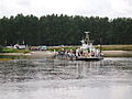
Elbe ferry


.JPG)

Economy and Infrastructure
.JPG)
Havelberg is poor in manufacturing. The important medium-sized manufacturing companies include the shipbuilding, vehicle and mechanical engineering sectors as well as furniture and plastics production. Historically, fishing, shipbuilding and shipping, and the brick industry were significant. Shipbuilding was carried out in three shipyards 100 years ago. Today only the Kiebitzberg shipyard of the Kiebitzberg Group produces sophisticated ships, boats and jetties, mainly made of aluminum. Furniture production and interior fittings also belong to this group. The luxury inland cruise ships of the Rhine class (2017) from Lloydwerft and MV Werften from 2017 to 2019 have received part of the interior fittings from the Havelberger Kiebitzberg Group.
The vast majority of today's economy operates in the service sector, including tourism. There are a significant number of farms in the vicinity. Havelberg is also a location of the Bundeswehr . The tank pioneer battalion 803 is based in the local "Elb-Havel barracks".
tourism
In Havelberg there is a marina in the winter harbor and a campsite on the Spülinsel, created in 1936. The Havel and Elbe cycle paths lead through Havelberg.
traffic

Havelberg is on the federal road 107 Pritzwalk - Genthin - Coswig . The next motorway connections are at the Meyenburg and Neuruppin junctions on the federal motorway 24 Hamburg - Berlin . Wittenberge via Bad Wilsnack and Seehausen via an Elbe ferry and Werben can be reached via country roads .
Regular buses from Regionalverkehr Westsachsen operate under the brand name stendalbus . There are regular bus connections with the state bus 900 to the train stations and towns of Glöwen in Brandenburg , Schönhausen (Elbe) , Tangermünde and Stendal .
The railway line to Glöwen , which opened in 1890, has been closed since 1971. So Havelberg has no rail connection. The nearest train station is nine kilometers away in Glöwen on the Berlin – Hamburg line . To the south of Havelberg are the Schönhausen (Elbe) and Stendal stations on the Berlin – Lehrte railway line and the Hanover – Berlin high-speed line . Individual ICE trains on the latter line also serve Stendal. Until 1993 there was passenger traffic on the Schönhausen – Sandau railway line , which went into operation in 1909 , but which was never extended to Havelberg.
At Havelberg the Havel flows into the Elbe.
Religions
The 2011 census in the European Union showed that of the 6,950 inhabitants of the Hanseatic city of Havelberg around 13% belonged to the Protestant and around 2% to the Catholic Church.
The evangelical parish of Havelberg belongs to the Prignitz parish of the Evangelical Church Berlin-Brandenburg-Silesian Upper Lusatia .
The Catholic Christians belong to the parish of St. Heinrich in Wittenberge .
Personalities
Honorary citizen
- 1895 Otto von Bismarck (1815–1898), Reich Chancellor
sons and daughters of the town
- Marcus Hassaeus (1549-1620), philologist
- Gregor Lange (around 1552–1587), cantor and composer
- Lucas Luidtke (after 1562–1596), canon at the Havelberg cathedral monastery
- Germanus Luidtke (1592–1672), Mayor of Stendal
- Christoph Friedrich I. von Bismarck (1652–1704), Prussian general
- Johann Friedrich Heynatz (1744–1809), linguist
- Heinrich Wilhelm Friedrich von Kleist (1751–1825), judge
- Johann Christian Franz (1762–1812), opera singer
- August Heinrich Kuhlmeyer (1781–1865), Prussian civil servant
- Friedrich Fubel (1810–1905), local politician in Halle (Saale)
- Louis Jacoby (1828–1918), engraver
- Berthold Woltze (1829–1896), painter
- Christian Wilberg (1839–1882), painter
- Karl Gussow (1843–1907), painter
- Johannes Dräseke (1844–1916), church historian
- Gustav Rüthning (1854–1944), historian
- Bruno Keil (1859–1916), classical philologist
- Hugo Rüdel (1868–1934), choirmaster
- Wilhelm Matthies (1896–1980), naval officer
- Karl Franzius (1905–1993), architect
- Anneliese Buschmann (1906–1999), politician (FDP)
- Kurt Henschel (1921–2008), painter and graphic artist
- Klaus Wissel (1924–1957), underwater photographer
- Klaus Dannegger (* 1943), cabaret artist
- Frank Meyke (* 1949), diplomat
- Andreas Freyer (* 1953), sculptor
- Susanne Melior (* 1958), politician (SPD)
- Karsten Kruschel (* 1959), writer
- Sabine Bothe (* 1960), handball goalkeeper
- Hans-Georg Wagner (* 1962), sculptor
- Wulf Gallert (* 1963), politician (Die Linke)
- Carsten Wulfänger (* 1963), politician (CDU)
- Gerald Meyer (* 1964), television presenter
- Jörg Asmus (* 1966), ornithologist
- Hans-Michael Schulze (* 1967), historian
- Annett Louisan (born 1977), singer
- Chris Schulenburg (* 1980), politician (CDU)
- Ulrich Siegmund (* 1990), politician (AfD)
Personalities associated with Havelberg
- Busso X. von Alvensleben (1468–1548), Bishop of Havelberg
- Petrus Conradi (around 1478–1561), cathedral dean at Havelberg Cathedral
- Johannes Welmecher (–1505), auxiliary bishop in Havelberg
- Matthäus Ludecus (1517–1606), cathedral dean at Havelberg Cathedral
- Reimar von Karstedt (around 1560–1618), dean of the Havelberg Cathedral
- Wichard von Möllendorff (1724–1816), Prussian general, canon of the cathedral chapter in Havelberg
- Max Degebrodt (1885–1976), painter, lived in Havelberg
- Gustav Gerneth (1905–2019), the oldest German and probably also the oldest man in the world, last lived in Havelberg
- Christoph Hein (* 1944), writer, lives in Havelberg
literature
- Historical Gazetteer Brandenburg - Part 1 - Prignitz - A-M . Modifications made by Lieselott Enders . In: Klaus Neitmann (Ed.): Publications of the Brandenburgisches Landeshauptarchiv (State Archive Potsdam) - Volume 3 . Founded by Friedrich Beck . Publishing house Klaus-D. Becker, Potsdam 2012, ISBN 978-3-88372-032-6 , pp. 318 ff .
- Lieselott Enders: Havelberg . In: Evamaria Engel u. a. (Ed.): German city book. Volume 2: City Book of Brandenburg and Berlin. Kohlhammer Verlag, Stuttgart 2000. pp. 234-241.
- Folkhard Cremer: Havelberg . In: Georg Dehio (Ed.): Handbook of German Art Monuments . Saxony-Anhalt I: Magdeburg district. Deutscher Kunstverlag, Munich 2002. pp. 376–400.
- Hans K. Schulze : Havelberg . In: Gerd Heinrich (Hrsg.): Handbook of the historical sites of Germany . Volume 10: Berlin and Brandenburg. With Neumark and Grenzmark Posen-West Prussia (= Kröner's pocket edition . Volume 311). 3rd, revised and expanded edition. Kröner, Stuttgart 1995, ISBN 3-520-31103-8 , pp. 217-221.
Web links
Individual evidence
- ↑ State Statistical Office Saxony-Anhalt, population of the municipalities - as of December 31, 2019 (PDF) (update) ( help ).
- ↑ Hanseatic City has been an official title of the city since June 1, 2008. ( Memento from July 9, 2009 in the Internet Archive )
- ↑ Main statutes of the Hanseatic city of Havelberg . October 9, 2014, § 1 Name, Designation and § 14 Local Constitution, p. 1 and 5 ( havelberg.de [PDF; 54 kB ; accessed on February 20, 2019]).
- ^ Frank G. Hirschmann: The beginnings of the urban system in Central Europe. The bishopric of the empire until the 12th century. Hiersemann Verlag, Stuttgart 2011. p. 998.
- ^ Schulze: Handbook of the historical places . P. 219.
- ^ Compare in detail on the subject of the relocation of the residence: Clemens Bergstedt: Ziesar and Wittstock. The residencies of the bishops of Brandenburg and Havelberg. In: Klaus Neitmann ; Heinz-Dieter Heimann (Ed.): Late medieval residences in the spiritual territories of Central and Northeast Germany. Lukas Verlag, Berlin 2009. pp. 241-294.
- ↑ Enders: City Book Brandenburg and Berlin. P. 237.
- ↑ Enders: City Book Brandenburg and Berlin. P. 236.
- ↑ Jürgen W. Schmidt: About the beginnings of sugar production in Havelberg 1791. In: Communications of the Association for the History of Prignitz Vol. 11 Perleberg 2011 pp. 164–170
- ↑ StBA: Changes in the municipalities in Germany, see 2002
- ↑ StBA: Changes in the municipalities in Germany, see 2005
- ↑ State Statistical Office of Saxony-Anhalt: Population movements (click on municipalities)
- ↑ Result of the local elections on May 25, 2014 ( Memento of the original from October 31, 2014 in the Internet Archive ) Info: The archive link was inserted automatically and not yet checked. Please check the original and archive link according to the instructions and then remove this notice. (Click on election results)
- ↑ Election result of the city council election 2014
- ^ Result of the mayoral election on April 26, 2015
- ^ Database census 2011, Havelberg, Hansestadt, Religion
Localities and districts: Dahlen | Damerow | Garz | Everyoneitz | Klein-Damerow | Kuhlhausen | Kümmernitz | Müggenbusch | Nitzow | Toppel | Vehlgast | Vehlgast-Kümmernitz | Forest Peace | Warnau | Wöplitz - Residential places: expansion | Expansion of the Garzer Mühle | Expansion of the Garzer Schleuse | Expansion of Kuhlhausen | Bungalow settlement Dahlen | Bungalow settlement Nitzow | Chausseehaus | Fischerberg | Julianenhof | Kiebitzberg | Theerofen | Forest homestead | Wendisch churchyard
Aland | Altmark Height | Altmark wipes | Arneburg | Bismark (Altmark) | Eichstedt (Altmark) | Goldbeck | Hassel | Havelberg | Hohenberg-Krusemark | Iden | Kamern | Klietz | Osterburg (Altmark) | Rochau | Sandau (Elbe) | Schollene | Schönhausen (Elbe) | Seehausen (Altmark) | Stendal | Tangerhütte | Tangermünde | Advertise (Elbe) | Wust-Fischbeck | Zehrental