
Guyana
| Co-operative Republic of Guyana | |||||
| Cooperative Republic of Guyana | |||||
|
|||||
| Motto : One People, One Nation, One Destiny ( English , "One People, One Nation, One Fate") | |||||
| Official language | English | ||||
| Capital | Georgetown | ||||
| State and form of government | semi-presidential republic | ||||
| Head of state | President Irfaan Ali | ||||
| Head of government | Prime Minister Mark Phillips | ||||
| surface | 214,970 km² | ||||
| population | 783,000 ( 159th ) (estimate from 2019) | ||||
| Population density | 4 inhabitants per km² | ||||
| Population development | + 0.5% (estimate for 2019) | ||||
gross domestic product
|
2019 | ||||
| Human Development Index | 0.682 ( 122nd ) (2019) | ||||
| currency | Guyana Dollar (GYD) | ||||
| independence | May 26, 1966 (from the UK ) |
||||
| National anthem | Dear Land of Guyana, of Rivers and Plains | ||||
| National holiday | February 23 (change of government form) | ||||
| Time zone | UTC − 4 | ||||
| License Plate | GUY | ||||
| ISO 3166 | GY , GUY, 328 | ||||
| Internet TLD | .gy | ||||
| Phone code | +592 | ||||
 .svg) |
|||||


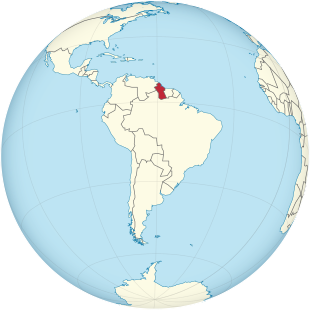
Guyana - officially Cooperative Republic of Guyana ([ guˈjaːna ], English Co-operative Republic of Guyana ) - is a state on the Atlantic coast of South America . It is bordered by Brazil to the south and west , Venezuela to the northwest and Suriname to the east .
geography

Guyana is between 1 ° and 8.5 ° north latitude and between 57 ° and 61 ° west longitude. The lowest point is on the Atlantic coast, the highest point is the mountain Roraima-Tepui with 2,810 m. On the border with Venezuela and Brazil rises the mountainous country of Guayana , after which the state was named. The main river is the Essequibo , which rises in the south of the country and flows into the Atlantic in the north. The 225 m high Kaieteur Falls are located in the Potaro National Park .
85% of the country is sparsely populated tropical rainforest . The west and south are criss-crossed by mountain ranges, in which the most important rivers of the country arise. There is a swampy stretch of coast along the coast. Behind it is a 20 to 70 km wide alluvial zone, some of which is at sea level and was diked by Dutch settlers in the 18th century and drained by countless drainage canals. This is where the country's agricultural belt is located, where rice , sugar cane , coconuts and citrus fruits are grown .
climate
The climate is tropical with rainfall up to 3000 mm per year; Average annual temperatures 27 ° C, maximum temperatures around 34 ° C, minimum temperatures around 20 ° C; Humidity 73-88%. There are two rainy seasons: strong from April to August, weaker September to November, stronger again until the end of January, then drought until the beginning of April.
environment
According to climate experts at the World Bank, Guyana is one of the countries in the South American-Caribbean region that will be particularly hard hit by a rise in sea levels as a result of climate change. A one meter rise in sea level in Guyana would inundate an area that is home to 70% of the population and 40% of the country's arable land. In 2004, the government protected an area of around 4,000 square kilometers in southwest Guyana, where the indigenous Waiwai people live.
According to the Environmental Performance Index , State and Dynamics of the Environmental System, published in January 2018, Guyana ranks 128th out of 180 countries.
Cities
The largest cities are (as of January 1, 2017): Georgetown 235,017 inhabitants, Linden 44,690 inhabitants, New Amsterdam 35,039 inhabitants and Anna Regina 12,448 inhabitants.
The agglomeration of Georgetown had 151,679 inhabitants at the 1991 census and 137,330 at the last census on September 15, 2002. This means that around 20 percent of the country's people are concentrated in the capital region.
population
Residents
| year | population |
|---|---|
| 1950 | 407,000 |
| 1960 | 572,000 |
| 1970 | 705,000 |
| 1980 | 780,000 |
| 1990 | 743,000 |
| 2000 | 753,000 |
| 2010 | 747,000 |
| 2019 | 783,000 |

According to the 2002 census, the population is composed as follows according to their ethnic origin:
- 43.4% Indian from the former British India
- 30.2% Creole , also Afro-Guyan
- 16.7% of mixed origins
- 9.2% indigenous peoples
- 0.2% Chinese
- 0.2% Portuguese
- 0.1% other Europeans
The main settlement is the coastal area. Individual Indian tribes are settled in the highlands .
Religions
Proportions of religions in the population:
- 56.7% Christians
- 17.0% Pentecostals
- 8.1% Catholics
- 7.0% Anglicans
- 5.0% Seventh-day Adventists
- 1.7% Methodists
- 1.1% Jehovah's Witnesses
- 17.9% other Christians
- 28.8% Hindus
- 7.3% Muslim
- 4.3% atheists
- 0.5% Rastafarians
- 0.1% Baha'i
- 1.3% others
Indian communities who practice their own ethnic religions still live in the highlands .
languages
Colloquial language is mainly a partially creolized English , as well as Indian languages (including Hindi ) and Indian languages . In addition to English, eleven other languages have the status of an officially recognized language.
history
Origin of the name "Guyana"
The name "Guyana" was derived from the original name of the Guiana region. The region includes Guyana, Suriname , French Guiana, and parts of Venezuela and Brazil . According to the Oxford English Dictionary, the name means "land of many waters".
Colonial times
Today's Guyana consisted of the colonies Essequibo , Demerara and Berbice founded by the Netherlands in the 17th and 18th centuries . In 1763 there was a slave revolt in Berbice under Cuffy , who is now regarded as a national hero .
The development of women's suffrage is linked to the colonial history of the area . In 1812, according to Frank A. Narain, women were granted the right to vote if they owned slaves or were able to pay income tax on at least 10,000 guilders; The source does not provide any information on whether equality was established between women and men.
The ownership of these areas changed several times between the colonial powers Netherlands , Great Britain and France until 1815 . After the defeat of Napoléon Bonaparte , the three colonies were transferred to the United Kingdom of Great Britain and Ireland at the Congress of Vienna in 1815 . In 1831 the colony of British Guiana was founded from this .
On August 1, 1834, the abolition of slavery came into effect. After the subsequent obligation to work for the former slaves expired on July 31, 1838 and the loss of manpower, especially on the plantations, the British hired contract workers from British India as replacements.
From 1849, only male British citizens were allowed to vote; their right to vote was still restricted by demands on their assets.
After Frank A. Narain, women were given back the right to vote in 1928; the right to vote continued to be linked to certain assets. Another source cites 1945 as the year for women to vote on the legislative body of British Guiana .
In 1953, British troops intervened in British Guiana amid fears that the People's Progressive Party (PPP) , founded by the couple Janet and Cheddi Jagan , wanted to establish a communist state in Guyana.
Research trips
The British geologist and topographer Charles B. Brown traveled to the mostly unexplored hinterland of the region between Suriname and Venezuela from 1868 to 1871 on behalf of the colonial administration. Brown was commissioned with the exact measurement of the river courses and geological investigations. Thanks to his 40-month research trips in the tropical jungle, numerous local settlements , deposits of mineral resources and topographical features in the interior of the country were documented. According to the research results of Schomburgk from 1841 to 1844, Brown's work was also of importance for the exact definition of the border lines with the neighboring states of Suriname, Brazil and Venezuela.
independence
Guyana finally achieved independence from the United Kingdom on May 26, 1966 and was declared a Cooperative Republic by the People's National Congress (PNC) on February 23, 1970 under Premier Forbes Burnham .
Ethnic conflicts between Afro-Guyans and Indian-Guyans have played a role in society and politics again and again since the 1960s. In 1978 Guyana hit the world news after the Jonestown massacre . After the assassination of a US politician, cult leader Jim Jones of the Peoples Temple gave his supporters the task of collective suicide. Over 900 people were killed.
In 1980 a new constitution was passed. The power of the prime minister was restricted and the executive office of the presidency was introduced.
Free market economy, elections
In 1989 the Guyanese government began an economic program that intended a drastic change from a state-controlled planned economy to a free market economy with open markets.
After the presidential elections of 1992, which were won by Cheddi Jagan of the PPP, there were violent riots in the capital Georgetown by militant supporters of the defeated PNC. After Jagan's death in 1997, his widow, Janet Jagan, was elected as the new president in December 1997 . In August 1999 she resigned for health reasons and Bharrat Jagdeo became the new President of Guyana. On September 2, 2006, Bharrat Jagdeo was confirmed in office as President. After the PPP's renewed electoral success in 2011, its candidate Donald Ramotar became the new president and successor to the previous incumbent Bharrat Jagdeo on December 3, 2011, who was no longer allowed to run after two terms in office.
The elections for the National Assembly on May 11, 2015 were won by the opposition alliance A Partnership for National Unity (APNU) and Alliance for Change (AFC) under the leadership of former Brigadier General David Granger . With that, the PPP lost power after 23 years. Granger was sworn in as President on May 16, 2015.
On December 21, 2018, Parliament expressed suspicion to Granger. According to the constitution, a new parliament should have been elected within 90 days. However, the government challenged the no-confidence vote in court and was able to gain time. On June 18, 2019, the Caribbean Court of Justice (CCJ) decided in the last instance that the government had to schedule new elections. The court-ordered elections finally took place on March 2, 2020. The electoral commission declared the ruling APNU-AFC coalition the election winner with 59,077 votes ahead of the PPP. According to the findings of international election observers, however, the counting of the votes was partly illegal. After sustained protests, the government and opposition finally agreed on a recount. However, this started very slowly. On May 18, 2020, only 642 of 2,339 ballot boxes were counted again. After the recount, Irfaan Ali of the PPP finally took office in August 2020.
politics
Form of government
The president is directly elected every five years. He is the chief owner of the executive. The legislature rests with the National Assembly . The legal system is based on the British model.
See also:
Political indices
| Name of the index | Index value | Worldwide rank | Interpretation aid | year |
|---|---|---|---|---|
| Fragile States Index | 66 of 120 | 101 of 178 | Stability of the country: Warning 0 = very sustainable / 120 = very alarming |
2020 |
| Democracy index | 6.01 out of 10 | 75 of 167 | Incomplete democracy 0 = authoritarian regime / 10 = complete democracy |
2020 |
| Freedom in the World Index | 74 of 100 | --- | Freedom status: free 0 = not free / 100 = free |
2020 |
| Freedom of the press ranking | 25.61 out of 100 | 51 of 180 | Recognizable problems for the freedom of the press 0 = good situation / 100 = very serious situation |
2021 |
| Corruption Perceptions Index (CPI) | 41 out of 100 | 83 of 180 | 0 = very corrupt / 100 = very clean | 2020 |
Human rights
- homosexuality
Amnesty International has issued a warning to the country in its annual human rights reports; especially because of the life imprisonment for homosexuals as well as often their abuse by the state.
Parliament is sticking to the law, but is also considering an anti-discrimination law, which, among other things, aims to protect against discrimination based on sexual identity.
- death penalty
Guyana is the only South American state that has retained the death penalty in criminal law (Brazil, Chile and Peru still have it in military law). The country is also criticized for this by human rights activists. The death penalty applies to murder, planned murder, mass murder, terrorism, rape, treason and torture. However, according to the constitution, their use is not compulsory. The last execution took place in 1997 (as of July 2017).
Foreign policy
International political memberships
Since independence in 1966, Guyana has sought an important role in international politics. The country was twice a member of the UN Security Council (1975–1976 and 1982–1983). Guyana has diplomatic relations with a large number of countries and organizations. The United Nations , the European Union (EU), the Inter-American Development Bank (IDB), the United Nations Development Program (UNDP), the World Health Organization (WHO) and the Organization of American States (OAS) all have offices in Georgetown. Guyana is also a member of the Commonwealth and CELAC and a founding member of the Caribbean community CARICOM .
Border conflicts
As a colonial heritage, Guyana has also taken over the border conflicts with neighboring countries. On the maps used here in the article, the controversial land areas of Guyana are added.
Border conflict with Venezuela
Venezuela, neighbor to the west, claims the entire area west of the Essequibo . An arbitration award made in 1899 by an international mediation commission, which was then accepted by Venezuela, determined today's boundaries. In the 1960s, information emerged that, in Venezuela’s view, proved the bias of the Mediation Commission at the time, whereupon Venezuela has since renewed its claims to the demarcation of the Essequibo. In 1966, the Venezuelan occupation of Ankoko Island intensified diplomatic relations between the two countries. If the Venezuelan claim is upheld, more than half of the Guyanese territory would fall to Venezuela. Guyana submitted the case to the International Court of Justice for decision in 2018 .
Border conflict with Suriname
The eastern neighbor Suriname also asserts territorial claims. After Suriname its maritime territorial claims against Guyana militarily through the use of two in June 2000 gunboats against the Canadian company CGX Energy had prevailed and the construction of a oil rig prevented the State Guyana called in February 2004, the Permanent Court of Arbitration , Permanent Court of Arbitration (PCA ) based in The Hague to clarify the border dispute.
In consultation with the PCA, Presidents Ronald Venetiaan and Bharrat Jagdeo publicly announced on September 20, 2007 the final judgment of the five-member arbitral tribunal of September 17, 2007. The arbitral tribunal awarded 33,152 square kilometers of the resource-rich marine area Guyana and Suriname 17,871 square kilometers . Both heads of state welcomed the decision and the settlement of the dispute. The verdict makes it possible for oil companies to begin exploring and developing the coastal basin. Oil reserves of 15 billion barrels and gas reserves of 1.2 trillion cubic meters are suspected on the ocean floor .
According to previous investigations, most of these deposits are probably on the Guyanese side. The area that led to the military intervention through Suriname in June 2000 and forced the CGX Energy company to withdraw is also within the area assigned to Guyana. The $ 34 million in compensation demanded by Guyana for this action was dismissed by the tribunal.
The arbitral tribunal further confirmed that the entire Corantijn river belongs to the Surinamese national territory. This means that Suriname has control of all shipping traffic from the mouth on the Corantijn.
military
The armed forces of Guyana are the Guyana Defense Forces (GDF) . They have a manpower of 3400.
Administrative structure

Guyana is divided into ten regions . The population figures in the table below refer to the census of May 10, 2012.
| No. | region | Area in km² | Total population | Inhabitants per km² |
|---|---|---|---|---|
| 1 | Barima-Waini | 20,339 | 24,275 | 1.19 |
| 2 | Cuyuni-Mazaruni | 47.213 | 17,597 | 0.37 |
| 3 | Demerara Mahaica | 2,232 | 311,563 | 139.03 |
| 4th | East Berbice-Corentyne | 36,234 | 123,695 | 3.41 |
| 5 | Essequibo Islands-West Demerara | 3,755 | 103.061 | 27.45 |
| 6th | Mahaica-Berbice | 4,190 | 52,428 | 12.51 |
| 7th | Pomeroon Supenaam | 6,195 | 49,253 | 7.95 |
| 8th | Potaro-Siparuni | 20.051 | 11,077 | 0.50 |
| 9 | Upper Demerara-Berbice | 17,040 | 41,112 | 2.41 |
| 10 | Upper Takutu-Upper Essequibo | 57,750 | 19,387 | 0.34 |
| Guyana | 214,999 | 751.223 | 3.49 |
economy

Generally
Guyana lives mainly from agriculture and mining . The country has one of the world's largest deposits of bauxite , its most important export product. Be exported continue Gold (see opencast Omai ), manganese ore , diamonds , sugar , rice , shrimp , rum and wood . Large parts of the forest were cut down for the extraction of mineral resources, but at the same time the country would be “particularly badly affected by a rise in sea levels in the wake of climate change”. Guyana is a founding state and a member of CARICOM , which has existed since 1973.
The unemployment rate for 2017 is given as 11.1%. Underemployment is widespread.
Oil production
By 2020, 13 oil fields with an estimated total volume of 5 to 10 billion barrels of oil had been discovered off the coast of Guyana. These quantities have been the world's largest newly discovered oil deposits for 20 years. Guyana has been exporting crude oil since 2020. Experts believe that with this deposit, Guyana will become the fourth largest oil producer in Latin America and that it will be able to produce more oil than Venezuela and Mexico. The IMF anticipates an increase in gross domestic product of around 30% for 2020.
Key figures
The gross domestic product (GDP) for 2017 is estimated at 4.5 billion US dollars. In purchasing power parity, GDP is $ 6.3 billion or $ 9100 per inhabitant. Real growth was 2.1%. Guyana is one of the poorest countries in Latin America. However, due to a planned expansion of oil production, the IMF expects per capita income to double within the next five years.
All GDP values are given in US dollars ( purchasing power parity ).
| year | 1980 | 1985 | 1990 | 1995 | 2000 | 2005 | 2006 | 2007 | 2008 | 2009 | 2010 | 2011 | 2012 | 2013 | 2014 | 2015 | 2016 | 2017 |
|---|---|---|---|---|---|---|---|---|---|---|---|---|---|---|---|---|---|---|
|
GDP (purchasing power parity) |
1.28 billion | 1.37 billion | 1.38 billion | 2.19 billion | 2.73 billion | 3.14 billion | 3.40 billion | 3.73 billion | 3.88 billion | 4.04 billion | 4.37 billion | 4.59 billion | 4.90 billion | 5.24 billion | 5.54 billion | 5.77 billion | 6.05 billion | 6.29 billion |
|
GDP per capita (purchasing power parity) |
1,690 | 1,862 | 1.915 | 3,014 | 3,675 | 4.223 | 4,567 | 5,003 | 5,189 | 5,380 | 5,669 | 6,076 | 6,469 | 6,890 | 7,254 | 7,533 | 7,874 | 8,161 |
|
GDP growth (real) |
−2.0% | 0.4% | −3.0% | 5.0% | −1.3% | −1.9% | 5.2% | 7.0% | 1.9% | 3.3% | 4.4% | 5.4% | 4.8% | 5.2% | 3.8% | 3.1% | 3.3% | 2.1% |
| Inflation (in percent) |
14.1% | 15.0% | 64.3% | 12.2% | 6.1% | 6.9% | 6.8% | 12.2% | 8.1% | 3.0% | 4.3% | 4.4% | 2.4% | 1.9% | 0.7% | −0.9% | 0.8% | 2.1% |
| Public debt (as a percentage of GDP) |
... | ... | ... | ... | 131% | 119% | 97% | 61% | 63% | 67% | 68% | 67% | 64% | 58% | 52% | 50% | 51% | 51% |
currency
The Guyana dollar is abbreviated as GYD according to ISO 4217 .
The Guyana dollar cannot be used outside the country and is subject to relatively high inflation . The smallest bill has a face value of 20 GYD, the largest one of 5000 GYD. In August 2017 you received the equivalent of 240.50 GYD for 1 EUR. Credit cards are only accepted by larger shops and banks. The account will be debited in US dollars.
State budget
The state budget in 2017 comprised expenditures equivalent to US $ 1,152 million , which was offset by income equivalent to US $ 939 million. This results in a budget deficit of 5.9% of GDP .
The national debt was 52.3% of GDP in 2017.
In 2006, the following areas accounted for government spending (in% of GDP):
traffic
The main transport hub is the capital, Georgetown . Connections with the interior of the country exist via roads, footpaths, inland waterways and small airfields.
- Streets
In 2011, the entire road network covered around 7,970 km, of which 509 km were paved. Driving in Guyana is left-hand traffic . In order to bypass hard-to-drive rapids, slopes were built from the endpoints of river navigation. There are other roads from the coast to the bauxite mining areas of Linden on the Demerara River and Berbice on the Berbice River in eastern Guyana. An asphalt road leads along the coastal plain from Corriverton on the banks of the Corantijn , the border river to Suriname , via New Amsterdam and Georgetown to Charity on the north coast. The larger rivers are crossed by ferries.
- Rail transport
Guyana has a small rail network for freight transport.
- shipping
The most important seaport is Georgetown. Of the most important rivers in the country, only the Demerara River is navigable for ore ships right into the mine areas. The other rivers, the Essequibo and its major tributaries Rupununi , Potaro (with the Kaieteur Falls ), Mazaruni and Cuyuni , are also important inland development arteries from the coast. However, they are criss-crossed by numerous rapids and waterfalls. In the sugar cane-growing area of the coastal plain, the canal network through the sugar cane fields is used - instead of roads that are difficult to maintain - to pull the sugar cane harvest to the factories on barges that are tied together and pulled from the banks by tractors.
- Air travel
An international airport could be built 40 km south of Georgetown because solid building ground was only found here in the hill country. In 2017 the arrival terminal was renewed.
Culture
The culture is shaped by colonial history and by the two largest ethnic groups: the Afro-Guyan, descendants of the former slaves from Africa , and the Indian Guyan, descendants of the contract workers brought into the country from the former British India in 1838 .
public holidays
The largest religious groups are reflected inter alia. also reflected in the holidays, Easter , Christmas , Holi and Diwali .
February 23 (1970) is a national holiday, Republic Day and at the same time annual Carnival Day ( Mashramani ) with colorful costume parades , music bands and decorated floats .
The writer Wilson Harris (1921-2018) became internationally known with his novels and essays.
media
- Guyana Chronicle, state daily newspaper (circulation approx. 40,000)
- Stabroek News, independent weekly newspaper (circulation approx. 29,000)
- Mirror, party weekly newspaper PPP (circulation approx. 20,000)
- New Nation, party weekly newspaper PNC (circulation approx.12,500)
- Catholic Standard, weekly newspaper (circulation approx. 9000)
- Guyana Broadcasting Corporation (state)
- private cable television channels with airtime for government programs
Sports
Cricket is Guyana's most popular sport and is considered a national sport. Guyana is one of the countries that, together with other Caribbean countries, forms the West Indies Cricket Team , one of the "national teams" in international cricket with test status , the most respected form of this sport. The West Indies cricket team competed in every Cricket World Cup and won the first two events in 1975 and 1979 . Together with Antigua and Barbuda , Barbados , Grenada , Jamaica , St. Kitts and Nevis , St. Lucia and Trinidad and Tobago , the 2007 Cricket World Cup was hosted .
See also
literature
- Louis-Marc Prudhomme: Journey to Guyana and Cayenne (1799). UNIKUM Verlag, Lindau 2013, ISBN 3-8457-1315-1 .
- Linda Schaumburg: The three Guiana: French Guiana, Suriname, Guyana. GRIN Verlag GmH, Munich 2013, ISBN 978-3-656-25288-7 .
Web links
- Database of indexed literature on the social, political and economic situation in Guyana
- Collection of links to Guyana
Individual evidence
- ↑ dpi-Guyana of August 2, 2020 , accessed September 1, 2020.
- ↑ population, total. In: World Economic Outlook Database. World Bank , 2020, accessed January 31, 2021 .
- ↑ Population growth (annual%). In: World Economic Outlook Database. World Bank , 2020, accessed January 31, 2021 .
- ↑ World Economic Outlook Database October 2020. In: World Economic Outlook Database. International Monetary Fund , 2020, accessed January 31, 2021 .
- ↑ Table: Human Development Index and its components . In: United Nations Development Program (ed.): Human Development Report 2020 . United Nations Development Program, New York 2020, ISBN 978-92-1126442-5 , pp. 344 (English, undp.org [PDF]).
- ↑ Information on the website of the Federal Foreign Office.
- ↑ Der Fischer Weltalmanach 2010, Frankfurt 2009, p. 240.
- ↑ Biodiversity in the Konashen Community Owned Conservation Area, Guyana. (PDF; 5.4 MB) Center for Applied Biodiversity Science, archived from the original on December 6, 2010 ; accessed on September 29, 2019 (English).
- ↑ Environmental Performance Index 2018 , accessed on January 26, 2018.
- ↑ Biggest Cities Guyana. Retrieved August 9, 2017 .
- ↑ Source: UN: World Population Prospects - Population Division - United Nations. Retrieved July 28, 2017 .
- ↑ population, total. In: World Economic Outlook Database. World Bank , 2020, accessed May 1, 2021 .
- ↑ Results of the 2002 Census, see: PDF
- ↑ Michel Dylong: Religion in Guyana. published: In: Markus Porsche-Ludwig, Jürgen Bellers (Hrsg.): Handbuch der Religionen der Welt. Volumes 1 and 2, Traugott Bautz, Nordhausen 2012, ISBN 978-3-88309-727-5 . P. 569.
- ↑ Focus Latin America: Guyana: Totem Poles for Independence Anniversary 2016 , November 26, 2015.
- ^ A b c Frank A. Narain: Historical Information Events and Dates on the Parliament of Guyana from 1718 to 2006 Parliament of Guyana, 2009, p. 112.
- ^ The National Archives , accessed August 8, 2018.
- ↑ - New Parline: the IPU's Open Data Platform (beta). In: data.ipu.org. April 16, 1953, accessed October 2, 2018 .
- ^ Charles B. Brown: Canoe and Camp Life in British Guiana. London 1876.
- ↑ Tjerk Brühwiller: change of power in Guyana. Multi-ethnic alliance wins . In: Neue Zürcher Zeitung of May 18, 2015, p. 5.
- ↑ New President Granger takes office , May 18, 2015, accessed May 20, 2020.
- ^ Granger announces fresh elections for Guyana after CCJ ruling . In: The Gleaner , June 18, 2019, accessed May 19, 2020.
- ↑ US, UK, Canada, EU say Region Four results not credible . In: Stabroek News , March 5, 2020, accessed May 19, 2020.
- ↑ GECOM adding two recount work stations . In: Stabroek News , May 19, 2020, accessed May 21, 2020.
- ↑ newsamericas: As Guyana Gets First Practicing Muslim President, OAS Urges Weakness In Country's Electoral System To Be Addressed. In: Caribbean and Latin America Daily News. August 3, 2020, accessed August 31, 2020 (American English).
- ^ Fragile States Index: Global Data. Fund for Peace , 2020, accessed January 23, 2021 .
- ^ The Economist Intelligence Unit's Democracy Index. The Economist Intelligence Unit, accessed February 6, 2021 .
- ^ Countries and Territories. Freedom House , 2020, accessed January 23, 2021 .
- ↑ 2021 World Press Freedom Index. Reporters Without Borders , 2021, accessed May 1, 2021 .
- ^ Transparency International (Ed.): Corruption Perceptions Index . Transparency International, Berlin 2021, ISBN 978-3-96076-157-0 (English, transparencycdn.org [PDF]).
- ↑ Hans Tanner: South America, Volume 2, Atlantic States. Georg Westermann Verlag, Braunschweig 1980, ISBN 3-14-509092-5 , p. 223 f.
- ↑ International Court of Justice: Arbitral Award of October 3, 1899 (Guyana v. Venezuela) , accessed September 14, 2020.
- ↑ Source: Bureau of Statistics Guyana
- ↑ Klaus Imbeck (also photos): Guyana: Das versiebte Leben. In: Geo-Magazin. Hamburg 1979, 6, pp. 86-100. Informative experience report: diamonds in the rainforest of Guyana are no bigger than the heads of a pin. The dream of getting filthy rich quickly drives men to the Mazaruni River with the digging sieve. But most of the time, the diamond fever ends in a whiskey rush. ISSN 0342-8311
- ↑ sas / dpa: Climate Conference: Forests for Money. In: Focus Online . December 6, 2007, accessed October 14, 2018 .
- ↑ http://www.klima.org/guyana Landesinformation auf www.klima.org, accessed on January 25, 2018
- ^ A b The World Factbook - Central Intelligence Agency. Accessed August 6, 2018 .
- ↑ Change of power in Guyana (finally) completed , August 3, 2020, accessed on January 9, 2021.
- ↑ Guyana: Rise of a New Oil Nation
- ^ Oil boom in Guyana
- ^ Report for Selected Countries and Subjects. Retrieved September 19, 2018 (American English).
- ↑ a b c The World Factbook
- ↑ EconomyWatch - Economy, Investment & Finance Reports
- ^ The Fischer World Almanac 2010: Figures Data Facts, Fischer, Frankfurt, September 8, 2009, ISBN 978-3-596-72910-4 .
- ↑ most important media, publication by the Federal Foreign Office, see
- ^ Games. Guyana Tourism Authority, archived from the original on June 6, 2008 ; Retrieved July 21, 2008 .

Member States of the United Nations
Argentina |
Bolivia |
Brazil |
Chile |
Ecuador |
Guyana |
Colombia |
Paraguay |
Peru |
Suriname |
Trinidad and Tobago 1 |
Uruguay |
Venezuela
Dependent Areas
Falkland Islands |
French Guiana |
South Georgia and the South Sandwich Islands
1 Mostly attributed to North and Central America in terms of cultural geography .
Full members:
Antigua and Barbuda |
Bahamas |
Barbados |
Belize |
Dominica |
Grenada |
Guyana |
Haiti |
Jamaica |
Montserrat |
St. Kitts and Nevis |
St. Lucia |
St. Vincent and the Grenadines |
Suriname |
Trinidad and Tobago
Associate Members:
Anguilla |
Bermuda |
British Virgin Islands |
Cayman Islands |
Turks and Caicos Islands
Member States:
Antigua and Barbuda |
Argentina |
Bahamas |
Barbados |
Belize |
Bolivia |
Brazil |
Chile |
Costa Rica |
Dominica |
Dominican Republic |
Ecuador |
El Salvador |
Grenada |
Guatemala |
Guyana |
Haiti |
Jamaica |
Canada |
Colombia |
Mexico |
Nicaragua |
Panama |
Paraguay |
Peru |
St. Kitts and Nevis |
St. Lucia |
St. Vincent and the Grenadines |
Suriname |
Trinidad and Tobago |
Uruguay |
Venezuela |
United States
Current Member States:
Antigua and Barbuda |
Australia |
Bahamas |
Bangladesh |
Barbados |
Belize |
Botswana |
Brunei |
Dominica |
Eswatini |
Fiji |
Gambia |
Ghana |
Grenada |
Guyana |
India |
Jamaica |
Cameroon |
Canada |
Kenya |
Kiribati |
Lesotho |
Malawi |
Malaysia |
Malta |
Mauritius |
Mozambique |
Namibia |
Nauru |
New Zealand |
Nigeria |
Pakistan |
Papua New Guinea |
Rwanda |
Solomon Islands |
Zambia |
Samoa |
Seychelles |
Sierra Leone |
Singapore |
Sri Lanka |
St. Kitts and Nevis |
St. Lucia |
St. Vincent and the Grenadines |
South Africa |
Tanzania |
Tonga |
Trinidad and Tobago |
Tuvalu |
Uganda |
Vanuatu |
United Kingdom |
Cyprus
Former Member States:
Dominion Newfoundland |
Federation of Malaya |
Ireland |
Sultanate of Zanzibar |
Tanganyika |
Zimbabwe
Coordinates: 6 ° N , 59 ° W