
District of Villingen
| coat of arms | Germany map | |
|---|---|---|

|
Coordinates: 48 ° 5 ' N , 8 ° 25' E |
|
| Basic data (as of 1972) | ||
| Existing period: | 1938-1972 | |
| State : | Baden-Württemberg | |
| Administrative region : | South Baden | |
| Administrative headquarters : | Villingen in the Black Forest | |
| Area : | 451 km 2 | |
| Residents: | 98,612 (May 27, 1970) | |
| Population density : | 219 inhabitants per km 2 | |
| License plate : | VL (1956–1971) VS (1972) |
|
| Circle key : | 08 3 46 | |
| Circle structure: | 37 municipalities | |
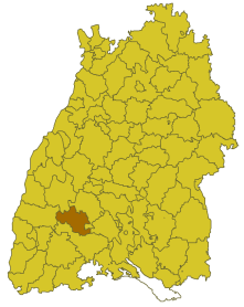
| Location of the district of Villingen in Baden-Württemberg | ||
  |
||

The district of Villingen was a district in Baden-Württemberg , which was dissolved in the course of the district reform on January 1, 1973 . In the last year of its existence it was called the district of Villingen-Schwenningen and then essentially became part of the Schwarzwald-Baar district .
geography
location
The district of Villingen was located in the southwest of Baden-Württemberg .
Geographically, the Villingen district almost exclusively had a share in the Black Forest . The southern district was part of the Baar landscape . The district town of Villingen in the Black Forest (today Villingen-Schwenningen ) was in the south of the district.
Neighboring areas
Its neighbors were in 1971 in a clockwise direction from Wolfach , Rottweil , Tuttlingen , Donaueschingen and Emmendingen to the north .
history
Before 1800, the area of the later district of Villingen belonged to various dominions , including Vorderösterreich and Fürstenberg . In 1803 the area came to Kurbaden , which initially formed several offices , including the offices and district offices of Villingen and Triberg, which changed several times over the course of history. In 1832 the Triberg office belonged to the Upper Rhine District , the Villingen office to the Seekreis . From 1864, both district offices belonged to the state commissioner district of Konstanz . In 1924 the Triberg District Office was dissolved and some communities came to the Villingen District Office. In 1936, other communities came to the district office of Villingen and in 1939 this was named the district of Villingen.
After the formation of the state of Baden-Württemberg in 1952, the district of Villingen belonged to the administrative district of South Baden . As a result of the community reform , the district changed several times from 1970: On September 1, 1971, the communities of Biesingen, Oberbaldingen and Öfingen, on January 1, 1972, the communities of Hochemmingen and Sunthausen and on April 1, 1972, the community of Unterbaldingen were incorporated into the city of Bad Dürrheim and thus moved from the district of Donaueschingen to the district of Villingen. On January 1, 1972, the district town of Villingen was combined with the town of Schwenningen am Neckar, which had belonged to the Rottweil district, to form the new town of Villingen-Schwenningen. On this occasion, the district was renamed the Villingen-Schwenningen district . On April 1, 1972, the municipality of Tannheim, district of Donaueschingen, was incorporated into the new town.
With effect from January 1, 1973, the Villingen-Schwenningen district was dissolved. Its communities went mostly in the newly formed Schwarzwald-Baar district, which thus became the legal successor of the Villingen district. A municipality (Tennenbronn) was incorporated into the enlarged Rottweil district.
Population development
All population figures are census results.
|
|
politics
District Administrator
The senior officials or district administrators of the district office or district of Villingen 1807–1972:
- 1807–1809: Philipp von Jagemann
- 1810–1819: Georg Gässler
- 1820-1826: Seraphin Magon
- 1826–1834: Franz Teufel
- 1834 : Sebastian Pezold (representative)
- 1835–1849: Karl Blattmann
- 1849–1853: Dominik Herterich
- 1853–1865: Xaver Weiss
- 1865–1866: Wilhelm Heinrich Lang
- 1866–1871: Karl Heinrich Baader
- 1871–1872: Adolf Fuchs
- 1872–1876: Carl Siegel
- 1876 : Alexander Pfisterer
- 1876–1882: Berthold Hatz
- 1882–1890: Wilhelm Haape
- 1890–1895: Julius Otto
- 1895–1899: Ernst Behr
- 1899–1902: Emil Bitzel
- 1902–1905: Heinrich Cron
- 1905–1908: Gustav Arnold
- 1908–1924: Adolf Bauer
- 1924–1932: Friedrich Wenz
- 1932–1945: Hellmut Müller
- 1945–1947: Karl Paul Bienzeisler
- 1947–1948: Othmar Diele (acting)
- 1948–1972: Josef Astfäller
coat of arms
The coat of arms of the district of Villingen showed in a shield split by silver and blue a red Johanniterkreuz at the front and a narrow silver bar at the back. The coat of arms was awarded by the Ministry of the Interior of Baden-Württemberg on June 16, 1958.
Economy and Infrastructure
traffic
There was no federal motorway running through the district . Therefore the district was only opened up by the federal highway 33 and district roads.
Communities
From 1936 onwards, 37 communities belonged to the Villingen district, including 3 towns, including the district town of Villingen in the Black Forest, which had been a major district town since April 1, 1956 .
On March 7, 1968, the state parliament of Baden-Württemberg set the course for a community reform . With the law to strengthen the administrative power of smaller municipalities , it was possible for smaller municipalities to voluntarily unite to form larger municipalities. It all started in the Villingen district on January 1, 1971, when the Rohrhardsberg community merged with the Schonach community in the Black Forest. In the period that followed, the number of municipalities steadily decreased until the district, from January 1, 1972, Villingen-Schwenningen district, was finally dissolved on January 1, 1973.
The largest municipality in the district was the district town of Villingen in the Black Forest, in the last year of its existence Villingen-Schwenningen . The smallest community was Herzogenweiler.
In the table, the municipalities of the Villingen district are before the municipal reform. All communities with the exception of Tennenbronn, which was assigned to the Rottweil district , are now part of the Schwarzwald-Baar district . The population figures refer to the census results in 1961 and 1970.
License Plate
On July 1, 1956, the district was assigned the distinctive sign VL when the vehicle registration number that is still valid today was introduced . It was issued until December 31, 1971. The district of Villingen-Schwenningen, which was newly formed on January 1, 1972, was given the VS distinguishing mark . This is still issued in the Schwarzwald-Baar district to this day.
Individual evidence
- ↑ a b Federal Statistical Office (ed.): Historical municipality register for the Federal Republic of Germany. Name, border and key number changes in municipalities, counties and administrative districts from May 27, 1970 to December 31, 1982 . W. Kohlhammer, Stuttgart / Mainz 1983, ISBN 3-17-003263-1 , p. 504 f .
.svg)
Basking | Backnang | Baden-Baden | Balingen | Biberach | Boeblingen | Bruchsal | Book | Bühl | Calw | Crailsheim | Donaueschingen | Ehingen | Emmendingen | Esslingen | Freiburg (city) | Freiburg (State) | Freudenstadt | Friedrichshafen | Göppingen | Hechingen | Heidelberg (city) | Heidelberg (Country) | Heidenheim | Heilbronn (city) | Heilbronn (Land) | Black Forest | Horb | Karlsruhe (city) | Karlsruhe (State) | Throat | Constance (city) | Constance (Country) | Künzelsau | Lahr | Leonberg | Loerrach | Ludwigsburg | Mannheim (city) | Mannheim (State) | Mergentheim | Mosbach | Muellheim | Münsingen | Neustadt | Nürtingen | Offenburg | Öhringen | Pforzheim (city) | Pforzheim (Country) | Rastatt | Ravensburg | Reutlingen | Rottweil | Säckingen | Saulgau | Schwäbisch Gmünd | Schwäbisch Hall | Sigmaringen | Sinsheim | Stockach | Stuttgart | Tauberbischofsheim | Tettnang | Tübingen | Tuttlingen | Überlingen | Ulm (city) | Ulm (State) | Vaihingen | Villingen | Villingen-Schwenningen | Waiblingen | Waldshut | Cheeks | Wolfach