
Madison County, Iowa
![The Madison County Courthouse in Winterset, listed on NRHP No. 76000790 [1]](https://de.wikipedia.org/wiki/Datei:Madison_County,_Iowa_Courthouse.jpg) The Madison County Courthouse in Winterset, listed on NRHP No. 76000790 |
|
| administration | |
|---|---|
| US state : | Iowa |
| Administrative headquarters : | Winter set |
| Address of the administrative headquarters: |
County Courthouse P.O. Box 152 winter set, IA 50273-0152 |
| Foundation : | January 13, 1846 |
| Made up from: | Polk County |
| Area code : | 001 515 |
| Demographics | |
| Residents : | 15,679 (2010) |
| Population density : | 10.8 inhabitants / km 2 |
| geography | |
| Total area : | 1456 km² |
| Water surface : | 3 km² |
| map | |
 |
|
| Website : www.madisoncoia.us | |
The Madison County is a county in the US -amerikanischen State Iowa . In 2010 , the county had 15,679 residents and a population density of 10.8 people per square kilometer. By 2013 the population had decreased to 15,448. The county seat is Winterset , the birthplace of John Wayne .
Madison County is part of the metropolitan area around Iowa's capital Des Moines .
geography
The county is located in central southwest Iowa in the southwestern suburb of Des Moines, around 70 km north of the Missouri border . It has an area of 1456 square kilometers, of which three square kilometers are water.
The county is traversed from west to east by the Middle River , which belongs to the Mississippi river basin via the Des Moines River .
The following neighboring counties border Madison County:
| Guthrie County | Dallas County | Polk County |
| Adair County |
.svg)
|
Warren County |
| Union County | Clarke County |
history

Madison County was formed on January 13, 1846 from former parts of Polk County in what was then the Iowa Territory . It was named after James Madison (1751-1836), the fourth President of the United States (1809-1817).
Madison County has been under self-administration since 1849.
Historical objects

The Cutler-Donahue Covered Bridge in Winterset, listed in the NRHP since 1976

The Holliwell Covered Bridge south of Winterset, listed in the NRHP since 1976

The Imes Covered Bridge near St. Charles, listed in the NRHP since 1979
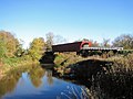
The Roseman Covered Bridge near Winterset, listed in the NRHP since 1976


Other historical objects:
| Population development | |||
|---|---|---|---|
| Census | Residents | ± in% | |
| 1850 | 1179 | - | |
| 1860 | 7339 | 522.5% | |
| 1870 | 13,884 | 89.2% | |
| 1880 | 17,224 | 24.1% | |
| 1890 | 15,977 | -7.2% | |
| 1900 | 17,710 | 10.8% | |
| 1910 | 15,621 | -11.8% | |
| 1920 | 15,020 | -3.8% | |
| 1930 | 14,331 | -4.6% | |
| 1940 | 14,525 | 1.4% | |
| 1950 | 13.131 | -9.6% | |
| 1960 | 12,295 | -6.4% | |
| 1970 | 11,558 | -6% | |
| 1980 | 12,597 | 9% | |
| 1990 | 12,483 | -0.9% | |
| 2000 | 14,019 | 12.3% | |
| 2010 | 15,679 | 11.8% | |
| 2013 estimate | 15,448 | -1.5% | |
| Before 1900 1900–1990 2000 2010–2013 | |||
population
According to the 2010 census , Madison County had 15,679 people in 5,843 households. The population density was 10.8 inhabitants per square kilometer. Statistically, 2.54 people lived in each of the 5,843 households.
The racial the population was composed of 98.1 percent white, 0.3 percent African American, 0.2 percent Native American, 0.3 percent Asian and other ethnic groups; 0.9 percent were descended from two or more races. Hispanic or Latino of any race was 1.3 percent of the population, regardless of ethnicity.
27.2 percent of the population were under 18 years old, 58.0 percent were between 18 and 64 and 14.8 percent were 65 years or older. 50.3 percent of the population was female.
The median income for a household was 55,607 USD . The per capita income was $ 26,775. 8.5 percent of the population lived below the poverty line.
Localities in Madison County
1 - partially in Warren County
structure
Madison County is divided into 16 townships :
|
|
The city of Winterset does not belong to any township.
Others
- Madison County is known for its many bridges, six of which are listed on the National Register of Historic Monuments.
- The film The Bridges on the River with Clint Eastwood and Meryl Streep was filmed here.
- The Madison County Covered Bridge Festival has been held here every year on the second weekend in October since 1970 .
See also
Individual evidence
- ^ Extract from the National Register of Historic Places.Retrieved March 13, 2011
- ↑ Madison County in the Geographic Names Information System of the United States Geological Survey Accessed February 27, 2011
- ↑ a b c U.S. Census Bureau, State & County QuickFacts - Madison County, IA ( July 14, 2011 memento on WebCite ) Retrieved November 11, 2014
- ↑ a b National Association of Counties.Retrieved November 11, 2014
- ↑ Extract from the National Register of Historic Places - No. 76000787.Retrieved January 17, 2012
- ↑ Extract from the National Register of Historic Places - No. 76000789.Retrieved January 17, 2012
- ↑ Extract from the National Register of Historic Places - No. 76000784.Retrieved January 17, 2012
- ↑ Extract from the National Register of Historic Places - No. 76000792. Retrieved January 17, 2012
- ^ US Census Bureau - Census of Population and Housing.Retrieved March 15, 2011
- ^ Extract from Census.gov.Retrieved February 16, 2011
- ↑ 2010 US Census Iowa Township and Other Subdivision Population. Retrieved July 23, 2019 .
- ^ The Madison County Covered Bridge Festival. Madison County Chamber of Commerce, accessed July 28, 2011 : "Each year on the second full weekend in October"
Web links
- Official website
- Madison County Chamber of Commerce
- Madison County Development Group
- city-data.com - Madison County, Iowa
List of counties in Iowa
Adair |
Adams |
Allamakee |
Appanoosis |
Audubon |
Benton |
Black Hawk |
Boone |
Bremer |
Buchanan |
Buena Vista |
Butler |
Calhoun |
Carroll |
Cass |
Cedar |
Cerro Gordo |
Cherokee |
Chickasaw |
Clarke |
Clay |
Clayton |
Clinton |
Crawford |
Dallas |
Davis |
Decatur |
Delaware |
Des Moines |
Dickinson |
Dubuque |
Emmet |
Fayette |
Floyd |
Franklin |
Fremont |
Greene |
Grundy |
Guthrie |
Hamilton |
Hancock |
Hardin |
Harrison |
Henry |
Howard |
Humboldt |
Ida |
Iowa |
Jackson |
Jasper |
Jefferson |
Johnson |
Jones |
Keokuk |
Kossuth |
Lee |
Linn |
Louisa |
Lucas |
Lyon |
Madison |
Mahaska |
Marion |
Marshall |
Mills |
Mitchell |
Monona |
Monroe |
Montgomery |
Muscatine |
O'Brien |
Osceola |
Page |
Palo Alto |
Plymouth |
Pocahontas |
Polk |
Pottawattamy |
Poweshiek |
Ring gold |
Sac |
Scott |
Shelby |
Sioux |
Story |
Tama |
Taylor |
Union |
Van Buren |
Wapello |
Warren |
Washington |
Wayne |
Webster |
Winnebago |
Winneshiek |
Woodbury |
Worth |
Wright
Coordinates: 41 ° 20 ′ N , 94 ° 1 ′ W