
Mazerolles (Charente)
|
Mazerolles Maseròlas |
||
|---|---|---|
|
||
| region | Nouvelle-Aquitaine | |
| Department | Charente | |
| Arrondissement | Confolens | |
| Canton | Charente-Bonnieure | |
| Community association | Charente limousine | |
| Coordinates | 45 ° 45 ′ N , 0 ° 32 ′ E | |
| height | 207-353 m | |
| surface | 17.45 km 2 | |
| Residents | 305 (January 1, 2017) | |
| Population density | 17 inhabitants / km 2 | |
| Post Code | 16310 | |
| INSEE code | 16213 | |
 Town Hall (Mairie) of Mazerolles |
||

Mazerolles ( Occitan : Maseròlas ) is a French municipality with 305 inhabitants (as of January 1 2017) in the department of Charente in the region Nouvelle-Aquitaine (before 2016: Poitou-Charentes ); it belongs to the Arrondissement Confolens and the canton Charente-Bonnieure (until 2015: canton Montembœuf ). The inhabitants are called Mazerollois .
geography
Mazerolles is located about 30 kilometers east-northeast of Angoulême . Mazerolles is surrounded by the neighboring communities of Saint-Adjutory in the north and north-west, Montembœuf in the north and north-east, Le Lindois in the east, Rouzède in the east and south-east, Montbron in the south, Orgedeuil in the south-west and Yvrac-et-Malleyrand in the west.
Population development
| year | 1962 | 1968 | 1975 | 1982 | 1990 | 1999 | 2006 | 2013 |
| Residents | 442 | 404 | 331 | 309 | 309 | 311 | 324 | 329 |
| Source: Cassini and INSEE | ||||||||
Attractions
- Notre-Dame church from the 12th century
- old castle hill (former tower hill castle)
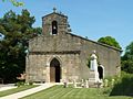
Notre-Dame church

Hill of the former castle

