Mouchy-le-Châtel
| Mouchy-le-Châtel | ||
|---|---|---|
|
|
||
| region | Hauts-de-France | |
| Department | Oise | |
| Arrondissement | Beauvais | |
| Canton | Chaumont-en-Vexin | |
| Community association | Thelloise | |
| Coordinates | 49 ° 20 ′ N , 2 ° 15 ′ E | |
| height | 56-125 m | |
| surface | 3.22 km 2 | |
| Residents | 82 (January 1, 2017) | |
| Population density | 25 inhabitants / km 2 | |
| Post Code | 60250 | |
| INSEE code | 60437 | |
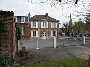
 Town hall (mairie) |
||
Mouchy-le-Chatel is a French municipality with 82 inhabitants (at January 1, 2017) in Oise in the region of Hauts-de-France . The municipality is located in the arrondissement of Beauvais and is part of the Communauté de communes Thelloise and the canton of Chaumont-en-Vexin .
geography
The municipality is located around four kilometers east of Noailles and six kilometers west of Mouy .
| 1962 | 1968 | 1975 | 1982 | 1990 | 1999 | 2006 | 2011 |
|---|---|---|---|---|---|---|---|
| 115 | 119 | 120 | 87 | 80 | 67 | 71 | 79 |
Attractions
See also: List of Monuments historiques in Mouchy-le-Châtel
- Saint-Étienne church from the 11th to 15th centuries
- Park of the palace, which was partially destroyed in the Second World War , of which the terrace, a round tower, stables, a cellar and some residential buildings restored in the 19th century by the architect Gabriel-Hippolyte Destailleur are still there, registered as Monument historique in 2009
Personalities
- Duc de Mouchy
- Hugues de Clermont, Seigneur de Mouchy, 1067 Seigneur de Creil ( House of Clermont )
- Philippe-Louis-Marc-Antoine de Noailles, prince de Poix (1752–1819), French politician
Web links
Commons : Mouchy-le-Châtel - Collection of images, videos and audio files
- additional information including OLD PHOTOS of the community
- Chateau de mouchy
- Hippolyte Destailleur (1822–1893), architect, restoration of the castle from 1856–1861
- Photo pendant la demolition du chateau de mouchy par son propriétaire
Individual evidence
- ↑ http://clochers.org/Fichiers_HTML/Accueil/Accueil_clochers/60/accueil_60437.htm
- ↑ Château in the Base Mérimée of the French Ministry of Culture (French)


