Pack (saddle)
| pack | |||
|---|---|---|---|
|
The village of Pack is located on the Styrian side not far from the top of the pass |
|||
| Compass direction | west | east | |
| Pass height | 1169 m above sea level A. | ||
| state | Carinthia | Styria | |
| expansion | Südautobahn A 2 / Packer Straße B 70 | ||
| Mountains | Packalpe | ||
| map | |||
|
|
|||
| Coordinates | 46 ° 57 '55 " N , 14 ° 58' 40" E | ||
The Pack or the Packsattel is a pass crossing from Lavanttal ( Carinthia ) to West Styria . It forms the southern border of the Packalm to the Koralm and is 1169 m above sea level. A. His area belongs to the Hirschegg-Pack community .
history
The Pack is an old post road crossing . A permanent mail connection from Klagenfurt via Völkermarkt and the Pack to Graz is documented as early as 1594 .
On old maps, the pack saddle is called “Four Thors”: This refers to the fact that the four paths that meet at the saddle were each closed with a gate to prevent grazing cattle from getting lost on other properties. A toll station is not occupied for the Pack.
traffic
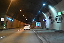
The south autobahn A 2 leads just south of the Packsattel through the Kalcherkogel tunnel (two tubes, 1993 m and 1968 m), to the west portal of which the Pack motorway junction connects, which leads uphill and joins the B 70 state road on the Packsattel. It is one of the most important transport routes (Klagenfurt - Graz - Vienna ) in Austria . On the packing section of this motorway, especially in winter when it is snowing, foggy or in summer on busy travel weekends, there are always traffic jams and traffic obstructions .
The Packer Street B 70 also leads over the pack. It ends in Graz. Before the construction of the southern motorway, it was part of the main route from Carinthia to Vienna.
The pack in historical representations
The “Vier Thöre” (pack saddle, top center) in the 19th century, recording sheet for the state survey
The pack in the 17th century in the "Topographia Ducatus Stiriae" by Georg Matthäus Vischer
Individual evidence
- ↑ Packsattel and surrounding area on ÖK 50 , www.austrianmap.at , Federal Office for Metrology and Surveying Austria, Austrian map.
- ^ Claudia Fräss-Ehrfeld: History of Carinthia. Volume 2 - the class epoch. Verlag Johannes Heyn, Klagenfurt 1994. ISBN 3-85366-685-X . P. 680.


