Scott County, Iowa
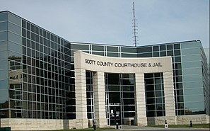
 The Scott County Courthouse in Davenport |
|
| administration | |
|---|---|
| US state : | Iowa |
| Administrative headquarters : | Davenport |
| Address of the administrative headquarters: |
County Courthouse 416 West Fourth Street Davenport, IA 52801-1147 |
| Foundation : | January 15, 1851 |
| Made up from: | Original County |
| Area code : | 001 563 |
| Demographics | |
| Residents : | 165,224 (2010) |
| Population density : | 142.6 inhabitants / km 2 |
| geography | |
| Total area : | 1186 km² |
| Water surface : | 27 km² |
| map | |
| Website : www.scottcountyiowa.com | |
The Scott County is a county in the US -amerikanischen State Iowa . In 2010 , the county had 165,224 residents and a population density of 142.6 people per square kilometer. By 2014 the population increased to 171,387. The county seat is Davenport , named after Colonel George Davenport , who set up a trading post here.
Scott County is part of the metropolitan area around the Quad Cities in Iowa and Illinois .
geography
The county is located in the far east of Iowa, borders Illinois to the east and southeast, the border being formed by the Mississippi . It has an area of 1186 square kilometers, of which 27 square kilometers are water. The following neighboring counties border Scott County:
| Cedar County | Clinton County | |

|
||
| Muscatine County |
Rock Island County (Illinois) |
history
Scott County was formed on January 15, 1851 as one of the original Iowa counties.
It was named after Major General Winfield Scott (1786-1866), who signed the peace treaty with Black Hawk and was Commander-in-Chief of the US Army in the Mexican-American War .
Settlement in this area began in Valley City, now known as Pleasant Valley, in 1833. Soon after, the towns of Rockingham and Davenport were founded.
population
| Population development | |||
|---|---|---|---|
| Census | Residents | ± in% | |
| 1840 | 2140 | - | |
| 1850 | 5986 | 179.7% | |
| 1860 | 25,959 | 333.7% | |
| 1870 | 38,599 | 48.7% | |
| 1880 | 41,266 | 6.9% | |
| 1890 | 43.164 | 4.6% | |
| 1900 | 51,558 | 19.4% | |
| 1910 | 60,000 | 16.4% | |
| 1920 | 73,952 | 23.3% | |
| 1930 | 77,332 | 4.6% | |
| 1940 | 84,748 | 9.6% | |
| 1950 | 100,698 | 18.8% | |
| 1960 | 119,067 | 18.2% | |
| 1970 | 142,687 | 19.8% | |
| 1980 | 160.022 | 12.1% | |
| 1990 | 150,979 | -5.7% | |
| 2000 | 158,668 | 5.1% | |
| 2010 | 165.224 | 4.1% | |
| 2014 estimate | 171,387 | 3.7% | |
| Before 1900 1900–1990 2000 2010–2014 | |||

According to the 2010 census , Scott County had 165,224 people in 67,049 households. The population density was 142.6 inhabitants per square kilometer. Statistically, 2.44 people lived in each of the 67,049 households.
The racial the population was composed of 86.7 percent white, 7.5 percent African American, 0.4 percent Native American, 2.5 percent Asian and other ethnic groups; 2.8 percent were descended from two or more races. Hispanic or Latino of any race was 6.3 percent of the population.
24.1 percent of the population were under 18 years old, 61.5 percent were between 18 and 64 and 14.4 percent were 65 years or older. 51.0 percent of the population were female.
The median income for a household was 52,735 USD . The per capita income was $ 28,948. 13.1 percent of the population lived below the poverty line.
Localities
Incorporated cities and non-incorporated census-designated places (CDP) :
| place | Residents 2010 |
Residents 2014 |
Type |
|---|---|---|---|
| Davenport | 99,685 | 102,448 | City |
| Bettendorf | 33,217 | 35,122 | City |
| Eldridge | 5651 | 6162 | City |
| Le Claire | 3765 | 3929 | City |
| Park View | 2389 | 2476 | CDP |
| Durant 2 | 1832 | 1825 | City |
| Walcott 1 | 1629 | 1630 | City |
| Blue Grass 1 | 1452 | 1623 | City |
| Buffalo | 1270 | 1298 | City |
| Princeton | 886 | 928 | City |
| Long Grove | 808 | 840 | City |
| Riverdale | 405 | 415 | City |
| Donahue | 346 | 369 | City |
| McCausland | 291 | 314 | City |
| Dixon | 247 | 248 | City |
| Maysville | 176 | 179 | City |
| New Liberty | 137 | 142 | City |
| Panarama Park | 129 | 139 | City |
1 - partly in Muscatine County
2 - partly in Cedar and Muscatine County
Unincorporated communities not recorded separately from the census :
structure
Scott County is divided into 13 townships :
|
|
The city of Davenport does not belong to any township.
See also
Individual evidence
- ^ Scott County ( English ) In: Geographic Names Information System . United States Geological Survey . Retrieved February 22, 2011.
- ↑ a b c U.S. Census Bureau, State & County QuickFacts - Scott County, IA. Retrieved January 21, 2016
- ↑ a b National Association of Counties. Retrieved January 21, 2016
- ^ US Census Bureau - Census of Population and Housing.Retrieved March 15, 2011
- ^ Extract from Census.gov.Retrieved February 16, 2011
- ↑ a b Extract from the National Register of Historic Places - No. 04000174 Retrieved November 30, 2011
- ↑ a b American Fact Finder. Retrieved January 21, 2016
- ↑ Missouri Census Data Center - Iowa ( January 21, 2016 memento on the Internet Archive ). Retrieved January 21, 2016
Web links
Coordinates: 41 ° 38 ′ N , 90 ° 38 ′ W


