Boos (Seine-Maritime)
| Boos | ||
|---|---|---|

|
|
|
| region | Normandy | |
| Department | Seine-Maritime | |
| Arrondissement | Rouen | |
| Canton | Le Mesnil-Esnard | |
| Community association | Métropole Rouen Normandy | |
| Coordinates | 49 ° 26 ' N , 1 ° 12' E | |
| height | 67-161 m | |
| surface | 14.03 km 2 | |
| Residents | 3,810 (January 1, 2017) | |
| Population density | 272 inhabitants / km 2 | |
| Post Code | 76520 | |
| INSEE code | 76116 | |
| Website | http://www.mairie-boos.com/ | |
 Boos Town Hall |
||
Boos is a French commune in the department of Seine-Maritime in the region Normandy . The municipality is located in the arrondissement of Rouen , is the main town ( chef-lieu ) of the canton of Le Mesnil-Esnard . The total population on January 1, 2017 was 406.
geography
Boos is a few kilometers southeast of Rouen . Boos is surrounded by the neighboring communities Franqueville-Saint-Pierre in the north and north-west, Montmaine in the north-east, La Neuville-Chant-d'Oisel in the east, Pîtres and Quévreville-la-Poterie in the south and Saint-Aubin-Celloville in the west and south-west .
The former Route nationale 14 runs through the municipality . Rouen Airport is also in the municipality .
Population development
| Population development | ||||||||
|---|---|---|---|---|---|---|---|---|
| year | 1962 | 1968 | 1975 | 1982 | 1990 | 1999 | 2006 | 2011 |
| Residents | 674 | 767 | 1.012 | 1,236 | 2,487 | 2,870 | 3,065 | 3,292 |
Attractions
- Saint-Sauveur church from the 13th century with alterations from the 16th and 17th centuries
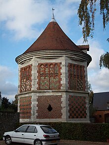
- 16th century houses and columbarium of the Abbey of Saint-Amand; the tiled floor of the columbarium was designed by Masséot Abaquesne in 1530
- Remains of the medieval castle
Web links
Commons : Boos - collection of pictures, videos and audio files
Individual evidence
- ↑ INSEE - Boos ( page no longer available , search in web archives ) Info: The link was automatically marked as defective. Please check the link according to the instructions and then remove this notice.


