
Fahr (Volkach)
|
Drive
City of Volkach
|
|
|---|---|
 |
|
| Height : | 202 m |
| Area : | 2.5 km² |
| Residents : | 636 (Jun. 2007) |
| Population density : | 254 inhabitants / km² |
| Incorporation : | May 1, 1978 |
| Postal code : | 97332 |
| Area code : | 09381 |
 Location of Fahr (bold) within the Volkach municipality
|
|
 Drive on the Mainschleife, seen from the Vogelsberg
|
|
Fahr (until 1978 Fahr am Main) is a district of the town of Volkach in the Bavarian district of Kitzingen in Lower Franconia. Until the merger with Volkach on May 1, 1978, Fahr was an independent municipality. The original addition "on the Main" comes from the past, because the ford of the former Prosselsheim royal farm already existed there in prehistoric times. Later a ferry connection was established that still exists today and gave the place its name.
Fahr only lost its importance for traffic with the construction of the Volkach Main Bridge in 1892. In addition to the ferry, Fahr is mainly characterized by viticulture and fruit growing . The typical development of the main axis of the village, the flower road, shows Fahr as Häckerhaufendorf. The location at the beginning of the so-called Mainschleife led to an early tourist development of the village.
Geographical location
Geography and natural structure
Fahr is located in the extreme northwest of the Volkach municipality. The village forms the end of the Lower Franconian district of Kitzingen, borders in the north on the municipality of Kolitzheim in the district of Schweinfurt - the district of Stammheim is closest to Fahr - and in the west on Kaltenhausen , district of Eisenheim in the district of Würzburg. In the east lies the core town of Volkach , while in the south, separated by the Main, is the Vogelsburg .
The nearest larger cities are Würzburg, about 19 kilometers away, and Schweinfurt , about 19.4 kilometers away.
In terms of nature, Fahr is located in the area of the Volkacher Mainschleife, which is counted as a sub-unit of the Middle Main Valley of the Mainfränkische Platten .
The village is located in the Maingau climate zone , which is one of the driest and warmest in Germany. This also explains the local viticulture. The Main near Fahr forms the beginning of the so-called Volkacher Mainschleife. Coming from Stammheim, the river flows around the town in the west and makes a large bend in the south-west of the district to continue flowing south from Fahr in the direction of Volkach. The geological composition of the area was revealed by the deepening of the river channel. In the Pleistocene , stones from the Upper Muschelkalk and Lower Keuper were deposited there.
Village structure

The driver district occupies an area of around 2.5 km² and is formed by the Elgersheim wasteland next to the village of Fahr, in the west of the district . The old Häckerhaufendorf is located in the center , to the east the Am Gries settlement is a new development area after the Second World War. The cemetery is on the edge of the built-up area. The new building area is to be expanded in 2017. The place is surrounded on three sides by the Main. The Lenz-Ziegler-Reifenscheid company can also be found on the river ( river kilometer 309).
Several named corridors surround the early medieval village. While most of these corridors refer to vineyards or orchards, the alluvial wood is the only forest section that extends along the KT 34 district road. Other, larger corridors are the Mönchsberg in the northeast, the Würmberg and the Kammerberg in the southeast. In the eastern part of the district, mentioned for the first time in the 14th century, there was the Urlaß forest (also Orles), which is now completely cleared. Four quarry ponds surround the site, and several have access to the Main. There is also the nature reserve Sandgrasheiden am Elgersheimer Hof, which is constantly being expanded with layers of sand from the neighboring lakes.
history
Prehistory and early history (until 1188)

Fahr has a very long history of settlement. Even in prehistoric times, the landscape in which the village is located was at least temporarily inhabited. During excavations, traces of settlement from the Neolithic Age were discovered . A mammoth tooth and worked teeth of wild horses were exposed. Several vessels and devices date from the time of the band ceramics , and a settlement of this culture has been located in what is now Fahr.
During the La Tène period there was an overlay of population everywhere in the loop region of the Main: the Celts who moved there displaced the original population. Today's village of Fahr was probably created by the Elbe Germans in the first century BC and is therefore one of the oldest places on the Mainschleife alongside Volkach. The Elbgermanen needed a Main crossing between the fortified Vogelsburg , the secular and spiritual center of the region, and the Prosselsheim settlement.
Fahr was the resting place and ferry location at the beginning of the Main loop. The settlement was suitable for this use because the banks were easily accessible. In the 6th and 7th centuries, the Franconian Merovingians colonized the region and, in addition to Christianity, also brought the first administrative structures with them. In order to organize the large, newly settled areas, the Franks no longer oriented themselves towards the Main. The smaller streams Volkach and Weidach moved into focus and Fahr was in an offside position.
Despite the old age of the place Fahr was not yet mentioned by name in the 8th century. In the 10th century the Franconian kingdom was slowly dissolved, the villages were given away to different rulers. The Vogelsburg and its surroundings had already been given away in the 9th century, and this donation was confirmed in 906 . Up to the year 900 the places around Eisenheim came to noble landowners.
Changing rulers (until around 1400)
In 1188 the provost Theoderich von Heidenfeld sold several vineyards to Lenthero de Fahr (Lenthero von Fahr), and the village appeared for the first time in the name of the ministerial . There was probably a castle in Fahr, the street name Schloßberg still gives evidence of it. In the meantime, the Counts of Castell , among others, had inherited the Frankish kings, followed by the Ebrach Abbey , the Heidenfeld Provost near Schweinfurt and the Haug Collegiate Monastery in Würzburg. At that time, the lords of the village of Fahr were the Counts of Castell.
Other gentlemen were also wealthy in Fahr. In 1205 the Haug monastery sold several vineyards and farmland to the Cisterze Ebrach. In 1222 Otto von Kaltenhausen and Elgersheim owned these vineyards. In 1238 the Casteller Ministeriale von Fahr reappeared. On May 23, 1223, Count Rupert II zu Castell renounced all rights in Fahr, which had previously been disputed with the Ebrach monastery.
In the Casteller partition contract of 1265/1267, Heinrich II zu Castell received the village. On May 1, 1282, he permitted the sale of a forest to the Ebrach monastery. Friedrich II zu Castell and his wife Willibirg sold another forest on June 10, 1301, again to the monastery. The influence of the Counts of Castell continued to decline when Heinrich II. And Friedrich II. Zu Castell sold vineyards to Ebrach on August 13, 1303.
In the 14th century, after other goods, in particular the Ebrach monastery, which had now established its own court in the nearby Elgersheim, the monastery had become the official landlord of Fahr. On August 20, 1347 the brothers Wolflin and Rüdiger Teufel donated other goods in the village to the Cistercian monastery. In 1376, Cunz Lenther von Fahr was enfeoffed with the Kreuzäckern by the abbey.
Establishment of the Hauger pen (up to around 1500)

However, the Ebrach monastery subsequently lost its influence in the Main loop region . The Haug Collegiate Foundation in Würzburg rose to be the new village lord . Fahr continued to be part of the Bishopric of Würzburg and the new lord of the village, Provost Hermann von Orlamünde , began to document the traditional rights and duties of the villagers in a document in 1403. Nevertheless, there was a dispute in 1406 because several goods had been unjustifiably sold.
A short time before that, around 1403, Fahr had already risen to become its own parish. On July 8th of this year, Heinrich was the first pastor to be found in the village. On February 14, 1450 the whole community was banned from the Jakobskloster in Bamberg by Dean Peter Hofmann . The drivers raided the vineyards of the Ebrach monastery and harvested them without permission. The sources are silent about further consequences for the residents.
In the period that followed, the monastery managed to better structure village life. A driver mayor is documented for the first time in the 15th century. The village still had an important traffic location with the ferry , from then on the ferry rights were granted to a resident. The 16th century was also marked by disputes with the other rulers in the area. There was a dispute with the Astheim Charterhouse and the city of Volkach over fishing rights and bank structures on the Main.
The Main as a trade route was important for the drivers because the Mainzoll could be levied here. The village lords had collected this duty for a long time, but in the 15th century the humanist Gregor Heimburg got the customs rights. Only after his excommunication , he was a follower of the Hussite doctrine pursued by the Pope , did customs come to the Würzburg bishopric in 1472, which kept him until the 19th century. Haug Abbey was finally established as the village lord.
Until the pen was dissolved (until 1802)
At the beginning of the 16th century, the farmers in Württemberg and Franconia began to revolt against the heavy burdens. The Peasants' War soon also affected the population at the Main Triangle. The drivers joined the so-called Volkacher Fähnlein and plundered the monastery on the Vogelsburg and the Charterhouse in nearby Astheim . Then the farmers occupied the ferry station. The Prince-Bishop soon put down the uprising and the drivers submitted to Bishop Konrad II of Thüngen in Volkach .
In contrast to many other villages in the area, the Reformation influence in Fahr was only very minor. In 1576, however, there was resistance to the pastor: the drivers did not feel that they were being properly cared for and attended the service in other villages. A short time later even the pastor with the money for the new rectory disappeared. However, the schoolmaster continued to teach the catechism .
During the Thirty Years' War the village suffered from frequent acts of war. Both the Protestant Swedes under their King Gustav II Adolf and the Catholic imperial ally, who were actually allies, marched through Fahr and caused great devastation. Between 1631 and 1634 the field preacher of the Swedish regiment Roßstein, Johann Schwäger, preached in Fahr for a time.
After the village had recovered from the war damage, the church began to be rebuilt at the beginning of the 18th century. A splendid church was built by 1726, and baroque splendor came to the Mainort. The villagers imitated the new style and a small, baroque park was created around the Max Krieger estate . At the same time, the place received a physicist , a surgeon, and a police officer was responsible for public safety.
In Bavaria (until today)
Haug Abbey ruled the village of Fahr for almost four hundred years. In 1802 the monastery was dissolved by Napoleon in the course of secularization . Fahr came to the enlarged Electorate of Palatinate Bavaria. As early as 1806, the place was added to the newly created Grand Duchy of Würzburg . It was not until 1814 that Fahr finally joined Bavaria, which had now become a kingdom . Fahr was slammed together with the nearby Elgersheim as a rural community to the Volkach district court.

The drivers' subjects had become citizens . However, a legal dispute with the tax authorities of the young state had been smoldering since 1809 . It was unclear who the etching , i. H. had to bear the entertainment costs. The process was still pending in 1818 and continued to be pursued by both sides. Only in 1823 did it end with a comparison between the administration and the municipality.
Difficult years began for Fahr in the middle of the 19th century. So far the place had lived mainly from viticulture . With the appearance of phylloxera there was a crisis in viticulture. Around 1840 beer bans were issued for the innkeepers. In the following years, together with Astheim, Fahr became one of the fruit-growing communities on the Mainschleife. In the years 1849 and 1852 there were major fires in the village, some of which destroyed several houses.
After the abbey was dissolved, the ferry came to private ferrymen who, as tenants , had to hand over money to the community every year. The ferry moved into the center of the action when the Bavarian army wanted to bring many soldiers there over the Main during the German War . Between July 12 and 13, 1866, over 3000 soldiers were quartered in Fahr at times, which was a multiple of the village population.
To avoid further fires, Fahr got a volunteer fire brigade in 1874. In 1870/1871 a total of 15 drivers were involved in the Franco-German War as soldiers, two of whom received a pension after the war. On August 1, 1886, the centrality of the place was further strengthened when a post office was established. It was later equipped with a telegraph station.
Towards the end of the 19th century, the public discussed building a bridge over the Main in Fahr. In the meantime, however, Volkach had become economically strong and the bridge was built between Astheim and the city in 1892. 1908 was driving with a water pipe equipped. With a total of 16 deaths, Fahr had to pay a high blood toll in the First World War . In 1920, cables were laid so that from then on there was electric light in the village.
Up until 1941, discussions were held to shorten the Mainschleife with a tunnel to make it easier for shipping to pass through. Fahr should be at the beginning of this tunnel. However, there was no implementation. During the Second World War there were some air raids on the village, especially because of the important traffic ferry. In 1960, a new ferry system was built, which today is the only free-moving one on the Mainschleife. With the municipal area reform , which came into force on May 1, 1978, the municipality of Fahr was incorporated into Volkach.
Place name
The name of the village has its origin in the primary function of settlement, the location of a ferry. The people settled at the ford of the Prosselsheim royal court and named the place after that. Fahr is probably the oldest settlement next to Volkach on the Mainschleife. People lived there as early as the first century BC, and the name was probably coined by the Elbe Germans.
Unlike many other places, the name has hardly changed over time. In 1225 the village was called "in vare", in 1293 "Var" and in 1401 "villa Vare" (village of Vare). In the 17th century, the form Fahr, which is still in use today, slowly solidified, with the terms " flecken " and " gemain Fahr" appearing. In 1634 the settlement was finally called "dorf Fahr". The term "Fahr am Main" still exists today.
In the past, the residents of the Obereisenheim on the other side of the Main gave the drivers so-called Ortsnecknames . One spoke of the fact that in Fahr “the begging sack is hanging on the gate”, referring to the poverty in the village. In addition, the inhabitants of the village were called drivers Sandhasen ( Main Franconian Sand'hosn). This was used to express that the drivers' soil is sandy and unsuitable for agriculture.
Administration and courts
|
The following administrative units were superordinate to the municipality of Fahr.
|
Fahr was judicially subject to the following instances.
|
coat of arms
|
|
Blazon : "Two crossed silver oars in red." |
| Justification for the coat of arms: The two crossed oars indicate the ferry in town, which was originally used with such oars. When the "common driving" was granted the ferry right, she was allowed to use the local seal. The tinging in red and silver refers to the Hochstift Würzburg. |
politics
From mayor to city council
In 1450 a "magistri civium", a citizen or village master for driving, was mentioned for the first time . The official names at that time were "Dorfmeister, Schultheiss , Schöffen and the whole community to Fahr". The mayors, two of whom were usually elected by the residents, represented the drivers to the authorities . However, they were not authorized to make decisions, but had to follow the instructions of the mayor of the Hauger Stift.
A special feature was the village law of 1575. According to this, Fahr was part of the 9th district court of the Würzburg monastery, which had its seat in Prosselsheim, but the district count was not allowed to enter the village. The mayor led him to the boundary of the district, from where he spoke right. Independence was also emphasized among the centschöffen, who only had to take a so-called hand vow and did not have to swear an oath .

| List of mayors of Fahr (selection) | |||||||
|---|---|---|---|---|---|---|---|
| Surname | Term of office | Remarks | |||||
| Konrad Weyker | gen. 1450 | together with Johannes Weygant | |||||
| Johann Georg Anne | gen. 1753 | ||||||
| Michael Krapf | gen. 1786, 1787 | ||||||
| Michael Münzel | gen. 1813 | ||||||
| Friedrich Fröhlich | gen. 1870 | ||||||
| Andreas Krieger | gen. 1901 | ||||||
| Michael Fröhlich | 1930 – after 1936 | ||||||
| Arthur Heinrich Krapf | gen. 1955 | ||||||
| Johann Nicola | -1978 | 2. Mayor Heinrich Krapf | |||||
After the inhabitants had been called " citizens " since 1700 , it took until the beginning of the 19th century before real civil rights and duties could be achieved. As a community , Fahr was very keen to be independent. In the course of the municipal reform, the connection to the city of Volkach was delayed until the municipal administration had to be warned by the authorities.
On February 5, 1975, a citizens' assembly decided to give up self-employment only if it was legally obliged to do so. On May 1, 1978 Fahr joined the community of Volkach. The mayor became a councilor in Volkach. Then the local spokesman Karl Seifert followed as advice. Today the district of Fahr is represented by the city council and local spokesman Günter Nicola.
Population development
Specific population figures for Fahr are known quite early on. Between 1450 and the Thirty Years War, the village always had around 250 inhabitants. By 1814 the population rose to just under 500. In the second half of the 19th century, Fahr always had over 500 residents. With 614 inhabitants, the highest number of inhabitants was reached in 1950. This number was reached in particular by the refugees after the Second World War. Due to the demographic development, the number has been falling since then.
| year | Inhabitant (place) | Residents (municipality) |
|---|---|---|
| 1450 | at 250 | |
| 1634 | at 250 | |
| 1867 | 541 | |
| 1871 | 518 | 534 |
| 1885 | 529 | 540 |
| 1900 | 464 | 482 |
| 1925 | 507 | 521 |
| 1950 | 614 | 630 |
| 1961 | 563 | 577 |
| 1970 | 581 | 591 |
| 1987 | 529 |
Culture and sights
Architectural monuments
Ensemble blossom road Fahr
The center of the place is the so-called flower road, which runs from northeast towards the Main. The main street is framed by several gable and eaves summer houses. Most of them are built on two floors and date from the 18th and 19th centuries. Some of them have a framework . The flower road turns left and goes into the so-called Maingasse to the river and the ferry.
Johanneskirche and figure of Sebastian

After the Christian community of Fahr was looked after externally by the original parish church on the Volkacher Kirchberg by the 11th century at the latest, a separate parish was established in Fahr by 1331 . Initially, the church was designed as a Gothic fortified church before the walls were torn down in the 15th century. The church was rebuilt between 1718 and 1726. The result was a baroque church, which is now part of the parish community of St. Urban on the Mainschleife.
The oldest part of the church is the choir tower from the 17th century. It was created as the so-called Julius Echter Tower and has the typical pointed helmet. The church was eastered and presented as a hall building . Most of the furnishings came into the interior in the 18th century. The most valuable element is the leaf on the high altar in the choir. It shows the "baptism of Christ" and was made by the Würzburg court painter Anton Clemens Lünenschloß .
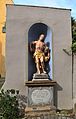
In front of the south side of the church there is an almost life-size representation of St. Sebastian in a large stone niche that ends with a pent roof . The figure is colored and stands on a pedestal with a sweeping cornice . The figure was created in 1773 and was decorated with the following inscription: “He has speared his bow / and set me as his target / he shoots the arrow, yours. 3/1773 ".
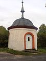
Kreuzkapelle
At first there was a wayside shrine at the place of the small chapel , which was popularly known as the “White Martyr”. In 1727 the couple Johann Adam and Margaretha Lutz from Fahr donated the small chapel. It was on April 16, 1728 by the parish priest Georg Adam Molitor benediziert . The chapel became the focus of the annual hall rides that have been held in Fahr since 1447.
During these rides, four wayside shrines were approached by the community in the corridor of the community. In 1956 the old custom was revived. Now the chapel was the destination of pilgrims on May 3rd and September 14th . The chapel presents itself as a circular complex , it closes with an eight-sided dome. Inside, several frescoes from the time it was built were exposed in the 20th century .
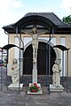
Cemetery with chapel and crucifixion group
The cemetery was built on the edge of the old town at the beginning of the flower road. The walled area has a chapel inside. It was built in 1706. The rectangular building with the curved hipped roof is entered from a round arched portal in the west. Inside there is a large baroque altar, on the altar sheet of which Saint Sebastian is depicted. Two twisted columns entwined with wine frame the picture.
Before the chapel was a large Crucifixion lineup. The figures originally stood in the old cemetery that was laid out around the church. The figures come from the first half of the 15th century and were probably created by the workshop that also worked the Madonna in the Iphöfer St. Vitus Church . The figures were last restored in 2009, which was done improperly. Today the crucified is framed by Mary and the Evangelist John.
Private houses and yards
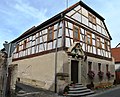
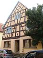
As a typical hacking village, Fahr is characterized by some magnificent houses and farms. The oldest surviving building in the village dates from 1629. It is located on Flower Street and was built as a two-story, eaves-standing structure. The house is surrounded by a barn , a large cellar and several stables . In the Traubengasse there is also an eaves-standing house with a half-timbered upper floor from the 17th century.

The three-storey rectory on Maingasse dates from the turn of the 17th and 18th centuries. It is the most powerful building in town. An inn at Blumenstrasse 2 has a hipped roof and was built in the 18th century. Its window frames are drilled , but the core of the building is older. An Immaculata was set up here as a house figure . A Häckerhaus on Kaulberg dates from 1712. It is built on the eaves side, the windows are also drilled. → see also: rectory (Fahr)
The flower road forms the center of the place. Several buildings from the 18th century have been preserved here. A half-hipped roof house with a splendid portal is located at Blumenstrasse 3. The building was decorated with an Immaculata. Opposite, a gable-independent gable roof has been preserved. A cantilevered half-timbered upper storey was attached to the eaves side house in Blumstrasse 8.
In Blumstrasse 10 one discovers a half- hipped building with a half-timbered upper floor. At the very end of the street, in Blumenstrasse 12, there is another eaves side house. It shows an Immaculata as a house figure and is marked with the year 1726. A courtyard on the Kaulberg also dates from the 18th century. There is also a house with drilled frames at Maingasse 12. The saddle roof construction can be assigned to the 18th century.
Wayside shrines and small memorials
As a Catholic, Franconian village, the corridor around Fahr has a large number of wayside shrines and small monuments. The late Gothic Marian column on Elgersheimer Weg is considered the oldest of these monuments . It is colored and worked with a richly decorated column. The so-called Ölbergbildstock on the road to Volkach dates from 1626. An inscription on the back of the picture plate is intended to protect the donor from crop failure and famine .
Typical religious monuments for the Main loop region are the so-called cross tugs. Fahr owns two of these depictions of Christ carrying the cross. In the vineyards of the Mönchberg you can discover a sandstone column with the representation of Christ from 1704. On the Kaulberg, the cross tractor was placed on a courtyard wall. This representation comes from the year 1716 and was also made of sandstone .
A particularly magnificent processional altar can be found on the way towards Stammheim. It has the shape of a tabernacle and concludes with the depiction of the Sebastiansmarter. It is closed on both sides, the back walls show the coronation of Mary and the Holy Family as reliefs. The altar was built in 1732. Another processional altar, which was set up opposite the cemetery, was decorated with a tablet of St. Lawrence .
Another wayside shrine stands on a pillar on the road to Gaibach. The coronation of Mary is on the front , while the fourteen helpers in need can be found on the back . The stick was created in the 18th century. In the 19th century a wayside shrine with a Pietà was erected in the south of the village. On the way to Gaibach there is also a crucifix from 1823. A house relief depicting the Most Holy Trinity was not re-qualified.

The interior of the Johanneskirche
The figure of Sebastian in front of the church
The Kreuzkapelle on the outskirts of the village
The crucifixion group in front of the cemetery chapel
The house in Blumgasse 3
The half-timbered house in Blumengasse 4

The wayside shrine from 1626


Elgersheimer Hof
The Elgersheimer Hof is actually in the hallway of the Volkach district of Elgersheim . However, both districts share the same area. The farm was mentioned as early as the 7th or 8th century. The farm was first mentioned in 1178, when Arnold von Rothenburg sold it to the Ebrach monastery. The monastery set up one of its official courts in the courtyard. After the dissolution of the monastery, the last abbot of Theres, Benedict II Mahlmeister , received the estate.
The Hofgut is oriented slightly to the southeast and forms a rectangle. The manor house is located in the far north-west of the complex, an auxiliary building is directly south of the building. Further modern ancillary buildings line up in the south, before the estate ends in the south with an old barn. Remnants of the wall can be found in the north and east of the complex. They are connected to one another in the northeast by a corner building.
Regular events
The pilgrimage to the Madonna of Mercy of Maria im Sand can be seen as the oldest annual event in Fahr . The drivers have been wreaking havoc over Kaltenhausen and Neuses am Berg to Dettelbach since around 1680. The reason for the procession was a vow that the congregation took after the Thirty Years' War. After the Guardian Angel Festival was held in 1897 , the pilgrimage takes place today on the last Sunday in August. The pilgrimage picture was created in 1998 and was created by Hans Mohr.
Other regular events shape the course of the year in Fahr. As in other places on the Mainschleife, a wine festival is celebrated once a year . In Fahr it takes place as a street wine festival in the flower street. In addition, the boys' association has been organizing the so-called Ariwa-Fete since 2004. The Ferry Festival in July forms the focal point of the festival calendar . The parish fair is celebrated between November 5th and 7th .
Economy and Infrastructure
economy
The economic development of Fahr always depended heavily on the climatic conditions on the Main loop due to the concentration on agriculture . When Fahr was first mentioned in 1188, vineyards were mentioned that were to be found east of the built-up area. The community suffered from bad wine years and flourished with good harvests. At the same time, the villagers also went fishing in the Main.
Fahr also suffered greatly from the collapse of viticulture with the appearance of phylloxera . Only after the Second World War did viticulture recover. The village still does not have its own vineyard, but shares the land owned by the Volkach councilor. This is why the location is called the driver councilor in the local area. Fahr was also a founding member of the Mainschleife wine cooperative in 1954.
After viticulture began to weaken at the beginning of the 19th century, so-called tree gardens were also established in Fahr . Fahr developed together with Astheim into a fruit-growing community. The population also traded in fruit in the 19th century. Fahr was particularly known for the cherries. In 1887 the export was 3,000 quintals of fruit. Even today there are fruit fields next to the vineyards.
Today, in addition to fruit growing and viticulture, cultural tourism has also established itself in Fahr. Guided tours are offered in the village , and there are several guest houses and overnight accommodations in Fahr. A loan association was founded in 1880, and today the Raiffeisenbank Fränkisches Weinland, based in Nordheim am Main, has a branch here.
| Vineyard | Size 1830 | Size 1887 | Size 1940 | Size 1976 | Compass direction | Slope | Main grape varieties | Great location |
|---|---|---|---|---|---|---|---|---|
| Driver councilor | 67 ha | 68 ha | 34 ha | 40 ha | South, southwest | 10-50% | Müller-Thurgau , Silvaner , Kerner , Bacchus | Volkacher Kirchberg |
traffic

Fahr was already a traffic junction at the Main Triangle in prehistoric times. Here was the ford of the prehistoric regional center Prosselsheim . A ferry later established itself here, which for a long time was the most important crossing of the Main in the region. The ferry was first mentioned in 1479. In order to compensate for the growing competition from the Astheim Main Ferry , a flying bridge was built in 1869 .
The ferry between Fahr and Kaltenhausen in the southwest of the old town still exists today . The Volkach Main Bridge has existed only a few kilometers south since 1892, but the ferry is still an important main crossing today, especially to the Eisenheim community in the Würzburg district . The Main ferry is the only one that runs freely on the Main Loop and is now used especially for tourist traffic.
Fahr can be reached via the KT 34 district road . Coming from Volkach it leads past the cemetery, there it is called Mönchbergstrasse. In the north of the village it is continued as Stammheimer Straße and runs in the direction of the Kolitzheim district of the same name. As a local connecting road between Gaibach and Fahr, the KT 32 district road ends at the Main ferry in Fahr.
Fahr is approached by several buses. The stop Abzweig Fahr is a special feature. It is located on the Eisenheim side of the Main in the Würzburg district , but the Main ferry can be reached quickly from there. In addition, the place is approached by line 8137 (Schweinfurt - Sennfeld - Hirschfeld - monastery) of the Mainfranken transport association . The so-called Mainschleifenshuttle stops at the bus stop at the cemetery.
education
| List of teachers (selection) | |||||||
|---|---|---|---|---|---|---|---|
| Surname | Mentioned | ||||||
| Franz Brach | gen. 1840 | ||||||
| Wilhelm Graner | gen. 1903 | ||||||
| Hans Stock | 1912 – after 1936 | ||||||
A school had existed in Fahr since the late Middle Ages . This facility was first mentioned in 1500. The respective teacher played an important role in the village. The schoolmaster taught the catechism to the children when the pastor was absent. The schoolhouse was rebuilt several times, for example in 1776. A hundred years later, in 1875, the school had to be rebuilt.
At the beginning of the 20th century, a private kindergarten was established in Fahr . As in many other villages in the area, it was sponsored by the sisters of the Dillinger Franciscan Sisters . At times, five sisters looked after the drivers for toddlers. In 1921 the women went to kindergarten. The nurses' station has since been closed.
Fahr has been part of the Volkach elementary school district since 1972 . Elementary and middle schools in nearby Volkach were combined under this name. Schoolchildren can obtain the qualifying secondary school diploma there and the secondary school leaving certificate via the so-called M-branch . Adult education is provided by the Volkach Adult Education Center.
The higher education also takes place in Volkach. A private girls' secondary school is located there. In addition, in the Volkach district of Gaibach, there is the Franken-Landschulheim Schloss Gaibach, a grammar school with secondary school and boarding school. The Steigerwald-Landschulheim in Wiesentheid is also close to Fahr. In addition, the pupils can visit the private monastery high school in Münsterschwarzach.
Associations and associations

Despite its small size, Fahr has a large number of clubs. The oldest association in the village is the volunteer fire brigade . It was founded in 1874 by 40 villagers and is organized in a fire brigade association. The fire brigade has a fire fighting vehicle (LF 8/6), a towing ladder (AL 10) and a fire brigade trailer (FwA-SA). In addition to the actual tasks, the Fahr fire brigade also takes on the security of events. The commandant is Kilian Meusert.
The sports club 1. FC Fahr is the second oldest association in the area. It was launched shortly after the Second World War in 1945. The central department is football, there is a women's netball team , a table tennis and a gymnastics group and a karate team . The footballers play in the A class . In 2003 the clubhouse was rebuilt.
The Fahr boys' association existed from 1924 to 1933 and was then banned by the National Socialists . The re-establishment took place on December 28, 1979. The association has dedicated itself to the maintenance of customs . Furthermore, there is a local association of the CSU and a senior citizens' club in Fahr. The Drivers Meebühna theater association has dedicated itself to amateur theater.
Personalities

Several influential personalities came from Fahr, especially in the 18th century the village produced some theologians. Professor Thaddäus Anton Dereser (1757-1827) was a member of the Carmelite Order and later worked at the Julius Maximilians University of Würzburg . He held several professorship positions at various universities. Dereser was elected rector of the Silesian Friedrich Wilhelms University in Breslau in 1819.
Lorenz Kündinger (1767-1818) was born on December 20, 1767 in Fahr. In 1783 he has been a Lawrence Kündinger as a student of philosophy in Würzburg enrolled . Soon afterwards he became a full professor in Würzburg and then headed the seminary for noble boys as prefect. He was also a sub-rain of the spiritual seminar for the good shepherd in Würzburg. On December 9, 1809, Kündinger also received his theological doctorate. Most recently he was pastor in Bergtheim, from where he wrote a polemic against Immanuel Kant.
As an independent community, Fahr granted several local pastors honorary citizenship in the post-war period . First, the clergyman Vinzenz Haus (born February 9, 1873 in Aschaffenburg , † December 27, 1951 in Fahr) received the honorary citizenship certificate. He had provided pastoral care to the community during World War II. On March 13, 1976 Georg Wehner (* March 24, 1912; † January 21, 1993 in Fahr) was honored. His work shaped the community between 1954 and 1993.
The media entrepreneur Leo Kirch (born October 21, 1926 in Würzburg; † July 14, 2011 in Munich ) became of national importance. He grew up in Fahr. Kirch founded a film distribution company, which he later expanded into one of the largest German media companies, the Kirch Group . Leo Kirch was one of the pioneers of private television. The third-placed third season of Germany's Next Top Model , Christina Leibold , came from Fahr. In addition, the place brought out the Franconian Wine Queen of 2012/2013 with Melanie Dietrich .
literature
Literature on driving
- Christiane Dietrich, Horst Nowak: Catholic parish church of St. John the Baptist in Fahr am Main. Leaflet . Drive 2012.
- Gerhard Egert: Fahr am Main 800-1500 . In: Ute Feuerbach (Ed.): Our Main Loop. 1978-1992 . Volkach 2008. pp. 247-254.
- Ute Feuerbach: 90 years of kindergarten St. Franziskus Fahr . In: Ute Feuerbach (Ed.): Our Main Loop. 2008-2017 . Volkach 2018. pp. 126–127.
- Ute Feuerbach: The stony road to becoming a citizen. The conflict between the municipality of Fahr and the tax authorities 1813–1823 . In: Ute Feuerbach (Ed.): Volkach 906-2006 . Volkach 2006. pp. 70-76.
- Stefan Meusert: The ferry system in Fahr . In: Ute Feuerbach (Ed.): Our Main Loop 1993-2007 . Volkach 2008. pp. 115-120.
- Herbert Meyer: The tower button certificates to drive . In: Ute Feuerbach (Ed.): Our Main Loop 1993-2007 . Volkach 2008. pp. 134-145.
- Georg Wehner: Baroque gardens in our homeland: Gaibach, Werneck, Wiesentheid, Volkach and Fahr . In: Ute Feuerbach (Ed.): Our Main Loop. 1993-2007 . Volkach 2008. pp. 37-39.
- Georg Wehner: Elgersheim near Fahr - an old Ebrach monastery courtyard . In: Ute Feuerbach (Ed.): Our Main Loop. 1993-2007 . Volkach 2008. pp. 22-24.
Other literature used
- Hans Bauer: Old and new coats of arms in the Kitzingen district . In: Yearbook of the district of Kitzingen 1980. In the spell of the Schwanberg . Kitzingen 1980. pp. 53-70.
- Hans Bauer: District of Kitzingen. An art and culture guide . Market wide 1993.
- Gerhard Egert: The honorary citizens of the city of Volkach . In: Ute Feuerbach (Ed.): Our Main Loop. 1993-2007 . Volkach 2008. pp. 51-58.
- Gerhard Egert: The place names as a historical settlement source. Situation structure and interpretation . In: Ute Feuerbach (Ed.): Volkach. 906-2006 . Volkach 2006. pp. 11-16.
- Gerhard Egert: The political spatial planning in the area of the Volkacher Mainschleife around 1814 . Ute Feuerbach (Ed.): Our Main Loop. 1978-1992 . Volkach 2008. pp. 267-270.
- Gerhard Egert: City and Parish Volkach am Main (A contribution to the city history of Franconia). Part I. The urban territory from the beginnings to the end of the Old Kingdom in 1803 . Volkach and Würzburg 1964.
- Gerhard Egert: On the history of fruit growing on the Mainschleife 1700–1900 . In: Ute Feuerbach (Ed.): Our Main Loop. 1978-1992 . Volkach 2008. pp. 47-58.
- Ute Feuerbach, Christa Volk: Volkach and its districts . Erfurt 2011.
- Monika Fritz-Scheuplein, Almut König, Sabine Krämer-Neubert, Norbert Richard Wolf: Dreidörfer fools stand on three rafters. Ortnecknames in Lower Franconia . Würzburg 2012.
- Johann Ludwig Klarmann: The Steigerwald in the past. A contribution to Franconian cultural studies . Gerolzhofen 2 1909.
- Theodor Kramer: Sources and research on the history of the diocese and bishopric of Würzburg, Volume 63 . Paderborn 2010.
- Rudi Krauß: The castles and palaces landscape: location distribution, brief description . In: District Administrator and District Council of the District of Kitzingen (Hrsg.): District of Kitzingen. Münsterschwarzach 1984. pp. 198-204.
- Herbert Meyer: The Old Volkacher Main Bridge . In: Ute Feuerbach (Ed.): Our Main Loop. 1978-1992 . Volkach 2008. pp. 323-326.
- oA: The district of Gerolzhofen from 1952–1955 . Gerolzhofen 1955.
- Franz Pfrang: The history of viticulture on the Main loop . In: Ute Feuerbach (Ed.): Our Main Loop. 1978-1992 . Volkach 2008. pp. 23-28.
- Anke Ruppert, Karl Heinrich Brückner: Pilgrimage to Dettelbach today - an inventory . In: Karl Heinrich Brückner, Peter Ruderich, Anke Ruppert, Reinhard Worschech: Maria help, it's time. From the story of the pilgrimage to “Maria im Sand” Dettelbach . Dettelbach 2005. pp. 31-167.
- Erika Stadler: Winegrowing traditions on the Mainschleife - then and now . In: In: Ute Feuerbach (Ed.): Our Main Loop. 1978-1992 . Volkach 2008. pp. 134-145.
- Karl Treutwein : From Abtswind to Zeilitzheim. History, sights, traditions . Volkach 4 1987.
- Georg Wehner: Royal household goods around the Main loop . In: Ute Feuerbach (Ed.): Our Main Loop. 1993-2007 . Volkach 2008. pp. 19-21.
Web links
Individual evidence
- ↑ Geography Giersbeck: Map 152 Würzburg , PDF file, accessed on January 10 of 2019.
- ^ Egert, Gerhard: City and parish Volkach am Main . P. 3.
- ↑ infranken: FC Fahr's no to enlarged building area , accessed on March 19, 2017.
- ↑ LZR: LZR brochure renaturation , PDF file, p. 11, accessed on March 8, 2019.
- ^ Treutwein, Karl: From Abtswind to Zeilitzheim . P. 70.
- ^ Egert, Gerhard: City and parish Volkach am Main . P. 9.
- ^ Egert, Gerhard: Drive on the Main . P. 248.
- ^ Krauss, Rudi: The castles and palaces landscape . P. 203.
- ^ Egert, Gerhard: Drive on the Main . P. 249.
- ^ Egert, Gerhard: Drive on the Main . P. 252.
- ^ Egert, Gerhard: Drive on the Main . P. 252.
- ↑ Wehner, Georg: Baroque gardens in our home . P. 39.
- ↑ Feuerbach, Ute: The stony path to becoming a citizen . P. 75.
- ↑ Meyer, Herbert: The tower button certificates to Fahr . P. 138.
- ↑ Meyer, Herbert: The tower button certificates to Fahr . P. 143.
- ^ Egert, Gerhard: The place names as a historical settlement source . P. 12.
- ^ Egert, Gerhard: Drive on the Main . P. 250.
- ^ Fritz-Scheuplein, Monika: Ortsnecknames in Lower Franconia . P. 51 and 80.
- ^ Gerhard Egert: Fahr am Main 800-1500. P. 247.
- ^ Bauer, Hans: Old and new coats of arms in the district of Kitzingen . P. 69.
- ^ Egert, Gerhard: Drive on the Main . P. 251.
- ↑ See: Meyer, Herbert: The tower button documents from Fahr .
- ↑ oA: The county Gerolzhofen from 1952 to 1955 . Gerolzhofen 1955. p. 1.
- ↑ Feuerbach, Ute (and others): Volkach and its districts . P. 101.
- ↑ Main-Post: Fahr offers peace and quiet in a beautiful landscape , accessed on March 19, 2017.
- ^ Egert, Gerhard: Drive on the Main . P. 250.
- ↑ Kgl. Statistisches Bureau (Ed.): Directory of the municipalities of the Kingdom of Bavaria according to the status of the population in December 1867 . XXI. Issue of the contributions to the statistics of the Kingdom of Bavaria. Ackermann, Munich 1869, p. 203 ( digitized version ).
- ↑ Kgl. Statistical Bureau (ed.): Complete list of localities of the Kingdom of Bavaria. According to districts, administrative districts, court districts and municipalities, including parish, school and post office affiliation ... with an alphabetical general register containing the population according to the results of the census of December 1, 1875 . Adolf Ackermann, Munich 1877, 2nd section (population figures from 1871, cattle figures from 1873), Sp. 1300 , urn : nbn: de: bvb: 12-bsb00052489-4 ( digitized ).
- ↑ K. Bayer. Statistical Bureau (Ed.): Localities directory of the Kingdom of Bavaria. According to government districts, administrative districts, ... then with an alphabetical register of locations, including the property and the responsible administrative district for each location. LIV. Issue of the contributions to the statistics of the Kingdom of Bavaria. Munich 1888, Section III, Sp. 1235 ( digitized version ).
- ↑ K. Bayer. Statistical Bureau (Ed.): Directory of localities of the Kingdom of Bavaria, with alphabetical register of places . LXV. Issue of the contributions to the statistics of the Kingdom of Bavaria. Munich 1904, Section II, Sp. 1317 ( digitized version ).
- ↑ Bavarian State Statistical Office (ed.): Localities directory for the Free State of Bavaria according to the census of June 16, 1925 and the territorial status of January 1, 1928 . Issue 109 of the articles on Bavaria's statistics. Munich 1928, Section II, Sp. 1354 ( digitized version ).
- ↑ Bavarian State Statistical Office (ed.): Official place directory for Bavaria - edited on the basis of the census of September 13, 1950 . Issue 169 of the articles on Bavaria's statistics. Munich 1952, DNB 453660975 , Section II, Sp. 1184 ( digitized version ).
- ↑ Bavarian State Statistical Office (ed.): Official city directory for Bavaria, territorial status on October 1, 1964 with statistical information from the 1961 census . Issue 260 of the articles on Bavaria's statistics. Munich 1964, DNB 453660959 , Section II, Sp. 866 ( digitized version ).
- ^ Bavarian State Statistical Office (ed.): Official place directory for Bavaria . Issue 335 of the articles on Bavaria's statistics. Munich 1973, DNB 740801384 , p. 188 ( digitized version ).
- ↑ Bavarian State Office for Statistics and Data Processing (Ed.): Official local directory for Bavaria, territorial status: May 25, 1987 . Issue 450 of the articles on Bavaria's statistics. Munich November 1991, DNB 94240937X , p. 366 ( digitized version ).
- ↑ Stadler, Erika: Winegrowing customs on the Main loop . P. 144.
- ↑ Ruppert, Anke (and others): Pilgrimage to Dettelbach today . P. 61.
- ^ Fahr-am-Main: Events , accessed on March 19, 2017.
- ^ Egert, Gerhard: Drive on the Main . P. 251.
- ^ Pfrang, Franz: History of viticulture on the Main loop . P. 27.
- ↑ Egert, Gerhard: On the history of fruit growing on the Main loop . P. 57.
- ↑ Fahr-am-Main: Tourismus , accessed on March 19, 2017.
- ↑ Raiffeisenbank Fränkisches Weinland: Fahrstelle Fahr ( Memento of the original from April 1, 2017 in the Internet Archive ) Info: The archive link was inserted automatically and has not yet been checked. Please check the original and archive link according to the instructions and then remove this notice. , accessed March 22, 2017.
- ↑ Vineyard information: Driver Ratsherr , accessed on March 27, 2017.
- ^ Pfrang, Franz: History of viticulture on the Main loop . P. 28.
- ↑ VVM-Info: Fahr timetables , accessed on March 30, 2017.
- ↑ Meyer, Herbert: The tower button certificates to Fahr . P. 143.
- ↑ Feuerbach, Ute: 90 years of kindergarten St. Franziskus Fahr . P. 126.
- ↑ KFV Kitzingen: Voluntary Fire Brigade Fahr am Main , accessed on March 19, 2017.
- ↑ Fahr volunteer fire brigade: homepage , accessed on March 19, 2017.
- ↑ FC-Fahr: Homepage , accessed on March 19, 2017.
- ↑ Burschenverein Fahr: Homepage ( Memento of the original from April 1, 2017 in the Internet Archive ) Info: The archive link was inserted automatically and has not yet been checked. Please check the original and archive link according to the instructions and then remove this notice. , accessed March 19, 2017.
- ↑ See: Kramer, Theodor: Sources and research on the history of the diocese and bishopric of Würzburg .
- ↑ Klarmann, Johann Ludwig: The Steigerwald in the past . P. 194.
- ↑ Egert, Gerhard: The honorary citizens of the city of Volkach . P. 57.
- ↑ Fahr-am-Main: Weinkönigin , accessed on March 19, 2017.

Astheim | Dimbach | Eichfeld | Elgersheim | Escherndorf | Drive | Gaibach | Hallburg | Koehler | Krautheim | Obervolkach | Öttershausen | Rimbach | Stettenmühle | Strehlhof | Vogelsburg | Volkach | Wenceslas Mill | Ziegelhütte (Krautheim)
Former districts : Herrenmühle | Kirchberg | Schaubmühle | Ziegelhütte (Escherndorf)