
Jablonné v Podještědí
| Jablonné v Podještědí | |||||
|---|---|---|---|---|---|
|
|||||
| Basic data | |||||
| State : |
|
||||
| Region : | Liberecký kraj | ||||
| District : | Liberec | ||||
| Area : | 5784.9106 ha | ||||
| Geographic location : | 50 ° 46 ' N , 14 ° 46' E | ||||
| Height: | 315 m nm | ||||
| Residents : | 3,622 (Jan 1, 2019) | ||||
| Postal code : | 471 25 | ||||
| License plate : | L. | ||||
| traffic | |||||
| Railway connection: |
Řetenice – Lovosice – Česká Lípa – Liberec Svor – Jablonné v Podještědí (discontinued) |
||||
| structure | |||||
| Status: | city | ||||
| Districts: | 12 | ||||
| administration | |||||
| Mayor : | Petr Sadílek (as of 2010) | ||||
| Address: | náměstí Míru 22 471 25 Jablonné v Podještědí |
||||
| Municipality number: | 561631 | ||||
| Website : | www.jablonnevp.cz | ||||


Jablonné v Podještědí ( German German fork , until 1901 fork ) is a city in the Czech Republic .
geography
Geographical location

The city is located in the north of Bohemia at the foot of the Lusatian Mountains on the European route 442 between Nový Bor ( Haida ) and Liberec ( Reichenberg ) on the Panenský potok ( Jungfernbach ).
City structure
The city Jablonné v Podještědí consists of the districts Česká Ves ( Böhmischdorf ), Heřmanice v Podještědí ( Hermsdorf ), Jablonné v Podještědí ( German fork ) Kněžice ( United Herrendorf ) Lada v Podještědí (, Laaden , also charging ), Lvova ( Lemberk ) Markvartice ( Markersdorf ), Petrovice ( Petersdorf ), Pole ( Felden ), Postřelná ( Postrum ), Valdov ( Waldau ) and Zámecká ( Neufalkenburg ). Basic development units are Česká Ves, Heřmanice v Podještědí, Jablonné v Podještědí, Kněžice, Kněžičky ( Klein Herrendorf ) Lada v Podještědí, Lvova, Markvartice, Petro Vice, poles, Postřelná, Valdov, Zamecka, Židovice ( Jüdendorf ) and Zpěvná ( birdsong ).
The municipality is divided into the cadastral districts of Česká Ves v Podještědí, Heřmanice v Podještědí, Jablonné v Podještědí, Kněžice v Lužických horách, Lvová, Markvartice v Podještědí, Petrovice v. Lužickýchelná horácheln and
Neighboring places
| Krompach (Krombach) | Oybin , Zittau | Hrádek nad Nisou (Grottau) |
| Mařenice (Großmergthal), Kunratice u Cvikova (Kunnersdorf) |
.svg)
|
Rynoltice (Ringelshain), Janovice v Podještědí (Johnsdorf) |
| Velký Valtinov (Great Walten) | Brniště (Brims), Stráž pod Ralskem (Wartenberg am Rollberg) | Dubnice (Hennersdorf) |
history


Jablonné is one of the oldest cities in North Bohemia . It is located on Gabler Strasse , an old trade route that runs from Upper Lusatia via Zittau and the Zittau Mountains to Prague. According to tradition, the settlement of Jabel was founded in the middle of the 10th century by Pribislava, a sister of King Boleslav I (Bohemia) or his son Boleslav II (Bohemia) .
The coat of arms shows a three-tower city gate with a two-pronged fork in the opening. The previously significant fork in the road appears to be the most sensible interpretation of the city name, but a derivation of “gabela” (ie salt tax, salt storage, also toll) is conceivable.
The town founded by the Markwartinger Gallus von Lämberg ( Havel z Lemberka , Latin Gallus de Yablonni ) was first mentioned in 1249. His wife, St. In 1252, Zdislava founded a Dominican monastery with the St. Laurentius Church. From the middle of the 14th century, Gabel was owned by the Berka von Dubá gentlemen , from whom it came to Johann Joachim von Pachta von Reihofen . In 1419 it was captured and destroyed by the Hussites under the leadership of Jan Žižka . The displaced Dominicans returned after the Hussite Wars . During the Thirty Years' War it suffered several times and therefore lost its importance. On May 11th, 1788, a large city fire destroyed almost all buildings.
During the Seven Years' War , Gabel was occupied by Prussian troops . During the Wars of Liberation , General Joseph Poniatowski occupied the city with Polish troops . On August 19, 1813, Napoleon Bonaparte was in the city on his retreat from Russia . During the First World War there was a prisoner-of-war camp near the city in which up to 12,000 mostly Russian and Ukrainian soldiers were interned.
The convenient location of the city is evident from the people passing through: 1564 the later Emperor Maximilian II , 1577 Emperor Rudolf II , 1611 King Matthias , 1617 King Ferdinand II and 1779 Emperor Joseph II.
In 1901, Gabel received the official place name Deutsch Gabel to distinguish it from Gabel an der Adler . The official Czech name of the place was from this time Německé Jablonné .
Deutsch Gabel and the surrounding area were hit hard by the global economic crisis and its consequences. Until well into the 1930s, most of the residents were unemployed.
From 1938 to 1945 Deutsch Gabel belonged to the district of Deutsch Gabel in the Reichsgau Sudetenland , district of Aussig , of the German Empire .
On December 1, 1930, Deutsch Gabel had 2406 inhabitants, of which 2159 (90%) Germans, 180 (7%) Czechs and 65 (3%) foreigners.
After the Second World War , the German-speaking population from Deutsch Gabel was expelled in the direction of Zittau . Their property was confiscated by the Beneš decree 108 , the property of the Protestant church was liquidated by the Beneš decree 131 and the Catholic churches in Czechoslovakia were expropriated .
Until December 31, 2006 the city belonged to the Okres Česká Lípa .
Demographics
| year | Residents | Remarks |
|---|---|---|
| 1830 | 2.135 | in 371 houses |
| 1895 | 2,330 | |
| 1900 | 2,623 | German residents |
| 1930 | 2.406 | 180 of them are Czechs |
| 1939 | 2,160 |
| year | 1970 | 1980 | 1991 | 2001 | 2003 |
|---|---|---|---|---|---|
| Residents | 3,919 | 4,080 | 3,824 | 3,690 | 3,699 |
Attractions
- Dominican monastery with the monastery church of St. Laurentius in the style of a domed church . It was built in 1699–1722 by the builder Franz Anton ( František Antonín ) Berka von Dubá (1635–1706) based on a design by Johann Lucas von Hildebrandt based on the model of St. Peter's Church in Vienna . In a crypt in a mortuary shrine are the bones of St. Zdislava.
- Baroque plague column from 1686 on the market square
- Chapel of St. wolfgang
- On the western outskirts of the city there is an approximately 400 × 275 m large park, in the center of which is the Nový Falkenburk ( New Falkenburg ), which was built by Heinrich / Jindřich Berka von Dubá 1562–1572, rebuilt in the Baroque style in 1759 and after 1890 until 1945 was owned by the Reichenberg textile manufacturer Liebieg .
- Lemberk Castle
- Zdislava fountain
- Holy Trinity column in the style of the early baroque
Location views
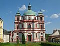
St. Laurentius Monastery Church
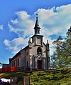
German Protestant Church
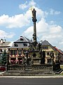
Plague column

Pachta hunting lodge

Monument to the Ukrainian prisoners in Hermsdorf
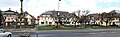
Jablonné v Podještědí market square in April 2015


.jpg)

.JPG)
Personalities
- Georg Tectander von der Jabel (1581–1614), German traveler to Persia, envoy of Emperor Rudolf II.
- Johann Jeremias Ergert (1730–1798), manufacturer, guild master and community elder of the city
- Franz Ergert (1758–1831), Austrian manufacturer and pioneer of industrialization
- Karl von Ergert (1795–1865), Austrian cavalry officer
- Wilhelm Ergert (1819-1892), cloth - producer and Mayor of the City (1850-1851; 1858-1871)
- Anton Ergert (1826–1888), businessman, first city councilor and district school councilor
- Louis Fleischner (1827-1896), American businessman and politician
- Otto Porsche (1858–1931), painter
- Vinzenz Kraus (1865–1926), Austrian tanner and politician, member of parliament
- Wenzel Bürger (1869–1946), architect
- Alfred Gürtler (1875–1933), Austrian statistician, economist and politician ( CS )
- Rudo Schwarz (1906–1983), German painter, draftsman, photographer and author
- Kurt Nelhiebel (alias Conrad Taler , * 1927), German author and radio journalist ( Radio Bremen )
literature
- Joachim Bahlcke , Winfried Eberhard, Miloslav Polívka (eds.): Handbook of historical places . Volume: Bohemia and Moravia (= Kröner's pocket edition . Volume 329). Kröner, Stuttgart 1998, ISBN 3-520-32901-8 , p. 109 f.
- Lillian Schacherl: Bohemia. Cultural image of a landscape. 4th edition. Prestel, Munich 1987, ISBN 3-7913-0240-X , p. 216.
- Alfred Schickel : The expulsion of the Germans. History, background, reviews. MUT, Asendorf 1985, ISBN 3-89182-014-3 .
Web links
Individual evidence
- ↑ http://www.uir.cz/obec/561631/Jablonne-v-Podjestedi
- ↑ Český statistický úřad - The population of the Czech municipalities as of January 1, 2019 (PDF; 7.4 MiB)
- ↑ http://www.uir.cz/casti-obce-obec/561631/Obec-Jablonne-v-Podjestedi
- ↑ http://www.uir.cz/zsj-obec/561631/Obec-Jablonne-v-Podjestedi
- ↑ http://www.uir.cz/katastralni-uzemi-obec/561631/Obec-Jablonne-v-Podjestedi
- ↑ Social Democrat. Central organ of the German Social Democratic Workers' Party in the Czechoslovak Republic from February 12, 1937.
- ^ A b Rudolf Hemmerle : Sudetenland-Lexikon (= German landscapes in the lexicon. 4). 2nd, expanded edition. Adam Kraft, Mannheim 1985, ISBN 3-8083-1163-0 , p. 114.
- ↑ Yearbooks of the Bohemian Museum of Natural and Regional Studies, History, Art and Literature . Volume 2, Prague 1831, p. 196, item 13).
- ↑ Johann Gottfried Sommer : The Kingdom of Bohemia . Volume 2: Bunzlauer Kreis , Prague 1834, p. 269, item 1).
- ^ Meyer's Large Conversational Lexicon . 6th edition, Volume 7, Leipzig and Vienna 1907, p. 246 .
- ^ A b Michael Rademacher: German administrative history from the unification of the empire in 1871 to the reunification in 1990. Landkreis Deutsch Gabel (Czech. Jablonné v Podjestedí). (Online material for the dissertation, Osnabrück 2006).
- ↑ http://www.czso.cz Czeski Urząd Statystyczny
- ↑ http://genealogy.euweb.cz/bohemia/duba2.html