Limbach (near Kirn)
| coat of arms | Germany map | |
|---|---|---|

|
Coordinates: 49 ° 44 ' N , 7 ° 33' E |
|
| Basic data | ||
| State : | Rhineland-Palatinate | |
| County : | Bad Kreuznach | |
| Association municipality : | Kirner Land | |
| Height : | 308 m above sea level NHN | |
| Area : | 9.18 km 2 | |
| Residents: | 296 (Dec. 31, 2019) | |
| Population density : | 32 inhabitants per km 2 | |
| Postal code : | 55606 | |
| Area code : | 06757 | |
| License plate : | KH | |
| Community key : | 07 1 33 059 | |
| Association administration address: | Bahnhofstrasse 31 55606 Kirn |
|
| Website : | ||
| Local Mayor : | Thorsten Pröschel | |
| Location of the local community Limbach in the Bad Kreuznach district | ||
Limbach is a municipality in the Bad Kreuznach district in Rhineland-Palatinate . It belongs to the Kirner Land association.
geography
The clustered village is located on the Limbach of the same name in the North Palatinate Bergland . The Welschrötherhof residential area, just under three kilometers to the south-southwest, is part of the local community. To the east is Bärweiler , south Hundsbach and west is Becherbach Kirn .
history
In the Middle Ages, the place belonged to the Raugräflichen Amt Naumburg or to the 'court' Becherbach , half of which came into the possession of the Counts of Sponheim-Kreuznach around 1350 and towards the end of the 14th century . Together with Becherbach and Schmidthachenbach , Limbach was one of the largest places in the Naumburg office, which was under the sovereignty of the Margrave of Baden in the 18th century. Around 1600 there were 26 households in the village. Limbach was also obliged to deliver 'Zollhafer' to the Lords of Steinkallenfels when the Limbach farmers sent the Kirner Markt.
After the conquest by French revolutionary troops, the villages of the Naumburg district , which had been annexed to the Herrstein district in 1776 , came under French rule from 1794 . Limbach was assigned to the Mairie Hundsbach in the canton of Meisenheim together with Heimberg and Krebsweiler . After the end of French rule, Becherbach was again the place of authority for these communities, which were now part of the Hesse-Homburg Oberamt Meisenheim . During the landgrave's time, between 1858 and 1860, Protestant residents of Limbach built a new late-Gothic church according to the plans of the Meisenheim architect Krausch. Today's Catholic chapel was built in 1893/4 on the site of the old church square.
By 1864, the village with 380 inhabitants had grown to 56 houses, which were inhabited by a total of 94 families. In 1866 the place became Prussian and after the dissolution of the Meisenheim district in 1932 it became part of the Bad Kreuznach district . As part of the Becherbach Office , Limbach came to the Kirn-Land Office after its dissolution in 1940 .
politics
Municipal council
The municipal council in Limbach consists of eight council members, who were elected by a majority vote in the local elections on May 26, 2019 , and the honorary local mayor as chairman.
mayor
Local mayor is Thorsten Pröschel. No candidate ran in the local elections on May 26, 2019, so his election was made by the local council on July 11, 2019. He is the successor to Alfons Ingenhaag, who was no longer a candidate.
coat of arms
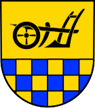
| Blazon : "In a divided shield above in gold a black plow, below blue-gold plowed." | |
|
Justification of the coat of arms: The plow refers to the rural structure of the Limbach community (until a few years ago it was still a pure farming community). The lower field, blue and gold, refers to the former affiliation to the front county of Sponheim .
On December 8, 1963, the local council commissioned a graphic designer to develop a design for a local coat of arms. At the meeting on April 13, 1965, the council accepted the draft presented. After approval by the State Archives, the Ministry of the Interior in Mainz granted permission on May 12, 1965 to use one's own coat of arms. |
Culture and sights
The Protestant church, built in neo-Gothic style, dates from 1860. The Catholic chapel was built in 1894.
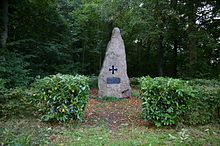
To the south of the village, at the confluence of Kreisstrasse 71 and Landesstrasse 182, there is a memorial erected in 1913 to commemorate the “ Liberation of the Rhineland from 12 years of enemy occupation ”, which is intended to commemorate the expulsion of the French by Blücher in 1814 . The monument was completely renovated in 2001.
See also: List of cultural monuments in Limbach
Economy and Infrastructure
The federal highway 41 runs in the north . In Kirn there is a train station on the Bingen – Saarbrücken line .
Web links
- Local parish Limbach on the website of the Verbandsgemeinde Kirn-Land
- Literature about Limbach in the Rhineland-Palatinate State Bibliography
Individual evidence
- ↑ State Statistical Office of Rhineland-Palatinate - population status 2019, districts, communities, association communities ( help on this ).
- ↑ State Statistical Office Rhineland-Palatinate (ed.): Official directory of the municipalities and parts of the municipality. Status: January 2018 [ Version 2020 is available. ] . S. 15 (PDF; 2.2 MB).
- ↑ a b Statistical Maps, Verbandsgemeinde Kirn-Land, 2009
- ^ The Regional Returning Officer RLP: Local council election 2019 Limbach. Retrieved September 23, 2019 .
- ^ The regional returning officer RLP: direct elections 2019. see Kirn-Land, Verbandsgemeinde, 12th line of results. Retrieved September 23, 2019 .
- ↑ Information sheet Kirn-Land for the area of the Verbandsgemeinde: Minutes of the meeting of the local council Limbach on July 11th, 2019. Edition 30/2019, official announcements and notices from the local congregations. Retrieved September 23, 2019 .


