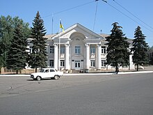
Perevalsk
| Perevalsk | ||
| Перевальськ | ||

|
|
|
| Basic data | ||
|---|---|---|
| Oblast : | Luhansk Oblast | |
| Rajon : | Perevalsk Raion | |
| Height : | 259 m | |
| Area : | 30.48 km² | |
| Residents : | 25,509 (2016) | |
| Population density : | 837 inhabitants per km² | |
| Postcodes : | 94308 | |
| Area code : | +380 6441 | |
| Geographic location : | 48 ° 26 ' N , 38 ° 49' E | |
| KOATUU : | 4423610100 | |
| Administrative structure : | 1 city | |
| Address: | вул. Леніна 21 94 300 м. Перевальськ |
|
| Statistical information | ||
|
|
||
Perewalsk ( Ukrainian Перевальськ ; Russian Перевальск Perewalsk ) is a city in Luhansk Oblast in eastern Ukraine . It has 25,000 inhabitants (2016) and is the administrative center of the raion of the same name 45 km southwest of the Luhansk Oblast center . The city is located in the densely populated and industrialized Donets Basin and borders directly on the city of Alchevsk .
history
Perewalsk was founded in 1889 as a mining site with the name Selesnjowski Rudnik (Селезнёвский рудник). From 1924 he was named imeni Paryskoji Komuny (імені Паризької Комуни) in honor of the Paris Commune , the unwieldy name was shortened to Parkommuna in 1938 . In 1964 the place got its current name and city status. After the Rajon was founded in 1965, the city became the center of the Rajon. The word perewal means “pass” or “transition”.
Since the summer of 2014, the town has been occupied by separatists from the Lugansk People's Republic during the war in Ukraine .
population
| 1923 | 1926 | 1939 | 1959 | 1970 | 1979 | 1989 | 2001 | 2005 | 2016 |
|---|---|---|---|---|---|---|---|---|---|
| 2,719 | 3,401 | 21,071 | 32,385 | 33.208 | 33.004 | 31,989 | 29,665 | 27,832 | 25,509 |
Source:
sons and daughters of the town
- Anatolij Jarosch (* 1952), shot putter
- Alexander Selin (* 1953), Russian Colonel General
Individual evidence
- ↑ a b Demography of Ukrainian cities on pop-stat.mashke.org
- ↑ Cabinet of Ministers of Ukraine , November 7, 2014 N 1085-р (Ukrainian)


