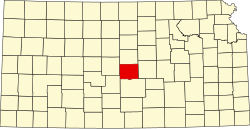
Rice County, Kansas
 Rice County Courthouse |
|
| administration | |
|---|---|
| US state : | Kansas |
| Administrative headquarters : | Lyons |
| Address of the administrative headquarters: |
County Courthouse 101 West Commercial Street Lyons, KS 67554-2727 |
| Foundation : | February 26, 1867 |
| Area code : | 001 620 |
| Demographics | |
| Residents : | 10,083 (2010) |
| Population density : | 5.4 inhabitants / km 2 |
| geography | |
| Total area : | 1886 km² |
| Water surface : | 4 km² |
| map | |
| Website : www.ricecounty.org | |
Rice County is a county in the US state of Kansas in the United States . The county seat is Lyons . The county is part of the dry counties , which means that the sale of alcohol is restricted or prohibited.
geography
The county is located in the geographic center of Kansas and has an area of 1,886 square kilometers, of which four square kilometers are water. It is bordered clockwise by the following counties: Ellsworth County , McPherson County , Reno County , Stafford County, and Barton Counties .
history
Rice County was formed on February 26, 1867. It was named after Samuel Allen Rice , a brigadier general of the US volunteers in the American Civil War , who was killed on April 30, 1864 near Jenkins Ferry, Arkansas.
On March 1, 1872, the first Sunday school was organized and the first school districts were formed. The first railroad train passed through the county on July 22, 1872, on its way from Hutchinson to Larned. In the same year the Salina, Atlanta & Raymond Railway Company was founded.
The first newspaper, the Rice County Herald , appeared on April 19, 1872. It was followed by The Rice County Gazette (1876), Homesteader (1876), The Weekly Bulletin (1877), The New Home (1879), The Recorder (1879) , The Lyons' Republican (1879), The Central Kansas Democrat (1879) and The Rural West (1881).
In Rice County there is a National Historic Landmark , the Tobias-Thompson Complex . A total of 16 buildings and sites in the county are listed on the National Register of Historic Places (as of August 30, 2017).
Demographic data
| growth of population | |||
|---|---|---|---|
| Census | Residents | ± in% | |
| 1870 | 5 | - | |
| 1880 | 9292 | 185,740% | |
| 1890 | 14,451 | 55.5% | |
| 1900 | 14,745 | 2% | |
| 1910 | 15.106 | 2.4% | |
| 1920 | 14,832 | -1.8% | |
| 1930 | 13,800 | -7% | |
| 1940 | 17,213 | 24.7% | |
| 1950 | 15,635 | -9.2% | |
| 1960 | 13,909 | -11% | |
| 1970 | 12,320 | -11.4% | |
| 1980 | 11,900 | -3.4% | |
| 1990 | 10,610 | -10.8% | |
| 2000 | 10,761 | 1.4% | |
| 2010 | 10,083 | -6.3% | |
| Before 1900
1900–1990 2000 + 2010 |
|||
As of the 2000 census , Rice County had 10,761 people in 4,050 households and 2,830 families in Rice County. The population density was 6 people per square kilometer. The racial the population was composed of 94.68 percent white, 1.15 percent African American, 0.57 percent Native American, 0.33 percent Asian, 0.04 percent of residents from the Pacific island area and 1.84 percent from other ethnic groups Groups; 1.39 percent were descended from two or more races. Hispanic or Latino of any race were 5.61 percent of the population.
Of the 4,050 households, 31.2 percent had children under the age of 18 living with them. 59.1 percent were married couples living together, 7.2 percent were single mothers, and 30.1 percent were non-families. 27.8 percent of all households were single households and 15.3 percent had people aged 65 or over. The average household size was 2.44 and the average family size was 2.97 people.
24.7 percent of the population were under 18 years old. 13.3 percent between 18 and 24 years, 22.8 percent between 25 and 44 years, 21.3 percent between 45 and 64 years and 18.0 percent were 65 years of age or older. The median age was 38 years. For every 100 females there were 92.2 males. For every 100 adult women aged 18 and over there were 88.2 men.
The median income for a household in the county is $ 35,671 , and the median income for a family is $ 40,960. Males had a median income of $ 31,175 versus $ 18,968 for females. The per capita income was $ 16,064.
8.5 percent of families and 10.7 percent of the population were below the poverty line.
Places in the county
- Atlanta Township
- Bell Township
- Center township
- East Washington Township
- Eureka Township
- Farmer Township
- Galt Township
- Harrison Township
- Lincoln Township
- Mitchell Township
- Odessa township
- Pioneer Township
- Raymond Township
- Rockville Township
- Sterling Township
- Union Township
- Valley Township
- Victoria Township
- West Washington Township
- Wilson Township
See also
Individual evidence
- ↑ GNIS-ID: 485043. Retrieved on February 22, 2011 (English).
- ↑ Listing of National Historic Landmarks by State: Kansas . National Park Service , accessed August 30, 2017.
- ↑ Search mask database in the National Register Information System. National Park Service , accessed August 30, 2017.
- ↑ US Census Bureau - Census of Population and Housing . Retrieved March 15, 2011
- ↑ Extract from Census.gov . Retrieved February 17, 2011
- ↑ Extract from census.gov (2000 + 2010). Accessed April 2, 2012
- ^ Rice County, Kansas , 2000 census data sheet at factfinder.census.gov .
Web links
Coordinates: 38 ° 18 ′ N , 98 ° 12 ′ W


