Agago district
| map | |
|---|---|
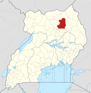
 Location of Agago |
|
| Basic data | |
| Capital | Agago |
| Geographical center | 2 ° 50 ′ N , 33 ° 20 ′ E |
| surface | 3,496.8 km² |
| population | 251,200 (as of 2020) |
| Population density | 71.8 inhabitants / km² |
| Time zone | UTC +3 |
Agago is a district in northern Uganda . The capital of the district is Agago .
location
The Agago district borders on the Kitgum district in the north, the Kotido district in the northeast, the Abim district in the east, the Otuke district in the south and the Pader district in the west.
history
The district was created in 2010 from parts of the Pader district.
Demographics
The population is estimated to be 251,200 in 2020. In the same year, 84.1 percent of them lived in urban regions and 15.9 percent in rural regions.
| Census year | population |
|---|---|
| 1991 | 100,659 |
| 2002 | 184.018 |
| 2014 | 227,792 |
economy
Agriculture with an emphasis on food crops is the backbone of the local economy.
Individual evidence
- ↑ a b Agago (district, Uganda) - population statistics, graphics, map and location. Retrieved July 4, 2020 .