Ntoroko District
| map | |
|---|---|
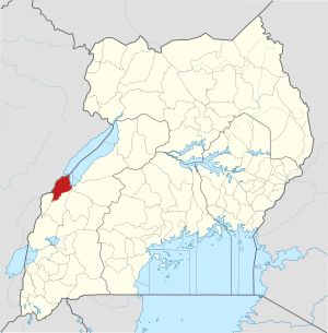
 Location of Ntoroko |
|
| Basic data | |
| Capital | Ntoroko |
| Geographical center | 1 ° 6 ′ N , 30 ° 24 ′ E |
| surface | 1,236 km² |
| population | 76,000 (as of 2020) |
| Population density | 61.5 inhabitants / km² |
| Time zone | UTC +3 |
Ntoroko is a district in western Uganda . The capital of the district is Ntoroko .
location
The district of Ntoroko is one of the two Ugandan districts west of the Rwenzori Mountains, the other is the district of Bundibugyo . The Ntoroko district is bordered to the west and north by the Democratic Republic of Congo , in the northeast on the district Hoima , on the east by the district Kibaale , in the south on the Kabarole District and on the southwest by the Bundibugyo district.
history
The Ntoroko District was created by the Ugandan Parliament and has existed since July 1, 2010. Before that, the district was part of the Bundibugyo District.
Demographics
The population is estimated at 76,000 for 2020. In the same year, 35.5 percent of them lived in urban regions and 84.7 percent in rural regions.
| Census year | population |
|---|---|
| 1991 | 24,255 |
| 2002 | 51,069 |
| 2014 | 67.005 |
economy
The local economy is dominated by agriculture.
Individual evidence
- ^ Ntoroko (District, Uganda) - Population Statistics, Graphics, Map and Location. Retrieved July 5, 2020 .