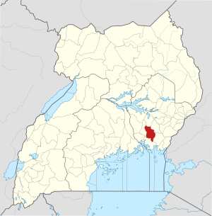
Iganga district
| map | |
|---|---|
 Location of Iganga |
|
| Basic data | |
| Capital | Iganga |
| Geographical center | 0 ° 45 ′ N , 33 ° 35 ′ E |
| surface | 1,019 km² |
| population | 402,600 (as of 2020) |
| Population density | 395.1 inhabitants / km² |
| Medium height | 1138 m |
| Time zone | UTC +3 |
| ISO 3166-2 | UG-203 |
Iganga is a district ( district ) in Eastern Uganda with 402,600 inhabitants. Like almost all districts of Uganda , it is named after its capital.
geography
Iganga is located in central Uganda, about 25 km north of Lake Victoria . The district is located at an average altitude of 1,138 m above sea level.
population
Iganga is within the Busoga tribal area with the traditional Lusoga language. Lusoga is a language closely related to Luganda that is widely spoken in the capital and in the media.
economy
Iganga is a rural district and, unlike Jinja in the west, the capital has no particular tourist significance. The majority of the population is employed in agriculture. Mainly corn, potatoes, sugar cane, coffee, tea and soybeans are grown. Mango and papaya trees grow in the district. The markets sell pineapples, tomatoes, sweet and non-sweet (“matooke”) bananas and pepper.