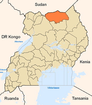
Kitgum District
| map | |
|---|---|
 Location of Kitgum |
|
| Basic data | |
| Capital | Kitgum |
| Geographical center | 3 ° 26 ' N , 32 ° 58' E |
| North South expansion | 90 km |
| East-west expansion | 165 km |
| surface | 9,773.63 km² |
| population | 283,546 (as of 2002) |
| Population density | 29 inhabitants / km² |
| Time zone | UTC +3 |
| ISO 3166-2 | UG-305 |
Kitgum is a district in northern Uganda , which borders Sudan in the north . It has an area of 9773.63 km². The main town of the district is Kitgum , 452 km from the capital of Uganda, Kampala . According to the 2002 census, the district has a population of 283,546, although the actual population may vary due to the refugee movements and the large number of refugee camps as a result of the rebel struggle of the Lord's Resistance Army (LRA). Most of the inhabitants live from subsistence farming .
Kitgum forms, together with Gulu and Pader the Acholi land that the main area of the people of Acholi is. Pader was also part of Kitgum until December 4, 2001 , but was then separated. Kitgum now consists of two counties, Lamwo and Chua. In 2010, the Lamwo Country was separated from the Chua Country and has since formed its own district, the Lamwo District .
Apart from regular raids by the LRA, the population of the area traditionally suffers from cattle theft, which is also committed with the participation of Lango groups, the Karamojong who settle further to the east and the people around the southern Sudanese Imatong Mountains (Buya, Lotuko , Didinga). The resulting feuds used to be fought with spears and are now fought with modern weapons. Lotuko, who are also victims of LRA attacks, are held responsible for the looting of fields on the Ugandan side.
Web links
- District Information Portal ( Memento of April 17, 2005 in the Internet Archive ) (English)
- Elizabeth Stites et al. a .: Livelihoods Movement on the Margins. Livelihoods and Security in Kitgum District. Feinstein International Center, Tufts University, Medford, Massachusetts, November 2006 Social study of the population in the district.