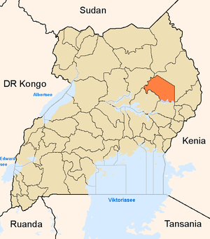
Katakwi District
| map | |
|---|---|
 Location of Katakwi |
|
| Basic data | |
| Capital | Katakwi |
| Geographical center | 1 ° 56 ' N , 34 ° 2' E |
| North South expansion | 80 km |
| East-west expansion | 95 km |
| surface | 5,114 km² |
| population | 307.032 (as of 2002) |
| Population density | 60 inhabitants / km² |
| Deepest point | 1036 m |
| The highest point | 1177 m |
| Time zone | UTC +3 |
| ISO 3166-2 | UG-207 |
Katakwi is a district in the east of Uganda with 307,032 inhabitants. The capital is the eponymous Katakwi . In the south, Katakwi has a share of the Bisina and Opeta lakes .
The district was spun off from Soroti in 1997 after it had existed as the North Teso District for some time in the 1970s and 1980s . It is divided into the three counties Kapelebyong, Amuria and Usuk, which in turn are divided into 14 subdistricts and one municipality. These are divided into 80 communities.
The main agricultural products are peanuts , sorghum and cassava . Katakwi was hit by a large-scale flash flood in September 2007, which particularly affected the regions around the cities of Amuria and Katakwi. In the media, it turned into a catastrophe that affected all of northern Uganda. Katakwi was annexed to the Sahel zone, although it is actually in eastern central Uganda. The rain measurements of the weather stations of other districts show since 1973 that a pour of 200 mm and more must be expected at least once per decade, which should actually represent a bit of normality for a tropical country like Uganda.
traffic
Katakwi has 581 km of paved roads and 20 km of rails on the northern line of the Uganda Railway .
Web links
- District Information Portal (English)