Kayunga District
| map | |
|---|---|
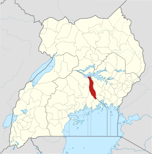
 Location of Kayunga |
|
| Basic data | |
| Capital | Kayunga |
| Geographical center | 1 ° 0 ′ N , 32 ° 52 ′ E |
| surface | 1,587.8 km² |
| population | 358,700 (as of 2012) |
| Population density | 225.9 inhabitants / km² |
| Time zone | UTC +3 |
| ISO 3166-2 | UG-112 |
Kayunga is a district in central Uganda . The capital is the city of the same name Kayunga .
geography
The district of Kayunga borders in the north on the district Amolatar , in the northeast on the district Buyende , in the east on the district Kamuli , in the southeast on the district Jinja and in the south on the district Buikwe , in the west on the district Luwero , in the north-west on the Nakasongola District . The capital, Kayunga, is about 74 kilometers northeast of Kampala and is connected by an all-weather asphalt road. The land mass of the district is approximately 1,587.8 square kilometers.
history
The Kayunga District emerged in December 2000 from the Mukono District .
In September 2009 , Kayunga tried to break away from the traditional kingdom of Buganda . When the king tried to visit the region, the Ugandan government refused to do so, which led to riots in Kampala. A total of thirty people were killed.
Population development
According to the census of 1991 , the district had a population of about 236,200 inhabitants. During the census of 2002 Kayunga had a total population of about 294,600 inhabitants. In 2012 , the district population was estimated at around 358,700. According to the 2014 census, the population of the Kayunga was approximately 368,064, with 181,920 men (49%) and 186,142 (51%) women. The population density is 231 people per square kilometer.
Administrative structure
The district consists of two counties , Bbaale County and Ntenjeru County .
economy
The agriculture is the main economic source in the district of Kayunga. About 90% of the district's population works in agriculture. Kayunga practices two types of agriculture, animal husbandry and arable farming , which are operated in a subsistence economy . The products grown include vanilla , passion fruit , watermelon , millet , corn , pineapple , matoke and cassava .
education
Kayunga has 157 government sponsored elementary schools and 50 private elementary schools. It also has 7 state sponsored secondary schools.
Web links
- official website
- District on ugandatravelguide.com
Individual evidence
- ↑ Distance between Kampala_ () and Kayunga_ (Kayunga) (Uganda). Retrieved September 1, 2018 (American English).
- ↑ Kampala hit by renewed violence . September 11, 2009 ( bbc.co.uk [accessed September 1, 2018]).
- ↑ Kayunga (District, Uganda) - Population Statistics, Charts, Map and Location. Retrieved September 1, 2018 .
- ↑ Kayunga. Retrieved September 1, 2018 (de-US).
- ↑ KAYUNGA DISTRICT | Uganda Travel Guide. Retrieved September 1, 2018 (American English).
- ^ Agriculture | KAYUNGA DISTRICT. Retrieved September 1, 2018 .
- ↑ Education | KAYUNGA DISTRICT. Retrieved September 1, 2018 .