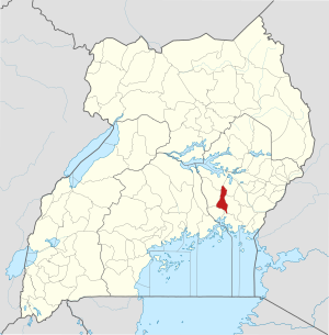
Luuka district
| map | |
|---|---|
 Location of Luuka |
|
| Basic data | |
| Capital | Luuka |
| Geographical center | 0 ° 42 ′ N , 33 ° 18 ′ E |
| surface | 650.1 km² |
| population | 267,100 (as of 2020) |
| Population density | 410.9 inhabitants / km² |
| Time zone | UTC +3 |
Luuka is a district in eastern Uganda . The capital of the district is Luuka .
location
The district of Luuka borders in the north with the district Buyende , in the northeast with the district Kaliro , in the southeast with the district Iganga , in the south with the district Mayuge , in the southwest with the district Jinja and in the northwest with the district Kamuli .
history
In the Kisoga tradition, Luuka is one of the five traditional principalities of the Busoga Kingdom. According to legend, Luuka was founded around 1737 and was part of the British Protectorate in Busoga in 1896. Its traditional ruler is known as Tabingwa. The modern district was created in 2010 from parts of the Iganga district.
Demographics
The population is estimated to be 267,100 in 2020. In the same year, 4.3 percent of them lived in urban regions and 95.7 percent in rural regions.
| Census year | population |
|---|---|
| 1991 | 130,408 |
| 2002 | 185,526 |
| 2014 | 238.020 |
economy
Subsistence farming is the main economic activity in the district.
Individual evidence
- ↑ Luuka (district, Uganda) - Statistics, graphics, map and location. Retrieved July 8, 2020 .