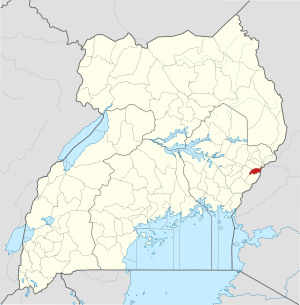
Bududa district
| map | |
|---|---|
 Location of Bududa |
|
| Basic data | |
| Capital | Bududa |
| Geographical center | 1 ° 1 ′ N , 34 ° 20 ′ E |
| surface | 250.8 km² |
| population | 210,173 (as of 2014) |
| Population density | 838 inhabitants / km² |
| Time zone | UTC +3 |
Bududa is a district ( district ) in Eastern Uganda . Bududa is bordered to the north by the Sironko district , to the east by Kenya , to the south by the Manafwa district and to the west by the Mbale district . The capital of the district is Bududa . The Bududa district has 210,173 inhabitants and an area of 250.8 square kilometers.
Individual evidence
- ↑ http://distancecalculator.globefeed.com/Uganda_Distance_Result.asp?fromplace=Mbale%20Post%20Office%2C%20Republic%20Street%2C%20Mbale%2C%20Eastern%20Region%2C%20Uganda&toplace=2C%20%Bud%Office% % 20Bududa% 2C% 20Eastern% 20Region% 2C% 20Uganda% 2C & dt1 = ChIJoW1COXG2eBcR6bLMF4pTLuU & dt2 = ChIJpwMzfFiteBcREm_3jUYW7WE