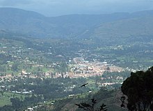
Kabale district
| map | |
|---|---|
 Location of Cabal |
|
| Basic data | |
| Capital | cabal |
| Geographical center | 1 ° 15 ′ S , 30 ° 0 ′ E |
| surface | 1,827 km² |
| population | 471,783 (as of 2002) |
| Population density | 258.2 inhabitants / km² |
| Time zone | UTC +3 |
| ISO 3166-2 | UG-404 |
Kabale is a district in southwest Uganda . Like almost all districts of Uganda , it is named after its capital.
geography
The area of the district bordering Rwanda is 1827 km². Green, intensely agricultural hills range from 1,219 to 2,347 meters above sea level. Because of this altitude, Kabale is colder than the rest of Uganda, the average temperature is 15 to 20 degrees Celsius and can drop to 7 degrees at night. The temperature comparison of the measurement periods 2000–2009 with 18.14 ° C and 1957–1966 with 17.49 ° C shows a slight warming with lower average wind speeds and significantly higher peak values. While in 1957 and 1958 55.4 km / h were reached, in 2001 and 2007 it was 79.5 and 74.1 km / h.
In the years 2000–2009, when summarizing the measurement period 2003/2004, Kabale achieved an annual rainfall average of 346.26 mm. The driest year was 2004 with 38.1 mm of precipitation and the wettest year 2001 with 938.55 millimeters. The heaviest shower fell on July 18, 2001 at 93.98 millimeters. The record amounts of the two torrential rains of October 12, 1995 with 246.89 mm and October 16, 1993 with 123.95 mm were no longer achieved. The years 1993–1999 reached an average rainfall of 285,723 mm annually. The period 1973–1979 showed a desert-like precipitation profile despite its somewhat fragmentary rain measurements with only 59.44 mm annually.
With sufficient irrigation, the relatively cool climate should enable the lucrative cultivation of apples, pears and plums, which is meanwhile also being propagated as a way to fight poverty.
population
Cabal has an estimated population of 629,400 (2000), mostly members of the Bakiga tribe. The population density is 344.5 people per km², making it the third highest in Uganda. Accordingly, the country is very fragmented. The average household has six to seven parcels of land spread over several hills. In addition to the Bakiga, the Batwa (Pygmies) and other ethnic groups are also represented.
tourism
The attraction of Kabales are mountain gorillas. The district capital of the same name, Kabale, is on the way to the national parks where these endangered animals live: Bwindi Impenetrable National Park and Mgahinga Gorilla National Park . Part of the Bwindi National Park is in Kabale.
Another attraction is Lake Bunyonyi , seven kilometers from Kabale City.

