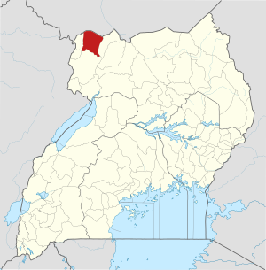
Yumbe District
| map | |
|---|---|
 Location of Yumbe |
|
| Basic data | |
| Capital | Yumbe |
| Geographical center | 3 ° 28 ′ N , 31 ° 15 ′ E |
| surface | 2,393 km² |
| population | 663,600 (as of 2020) |
| Population density | 277.3 inhabitants / km² |
| Time zone | UTC +3 |
Yumbe is a district in northern Uganda . The capital of the district is Yumbe .
location
The Yumbe District is one of the northernmost districts in Uganda. The district is bordered by South Sudan to the north, Moyo district to the east, Adjumani district to the southeast , Arua district to the south, Maracha district to the southwest and Koboko district to the west .
history
The district was created in 2006 from parts of the Arua district. The people in the district are still suffering from the effects of the civil war that lasted about twenty years (1980–2000). The peace agreement between Uganda National Rescue Front 2 and the government of Uganda was signed in Yumbe in 2000.
Demographics
The population is estimated to be 663,600 in 2020. In the same year 7.2 percent of them lived in urban regions and 92.8 percent in rural regions. The majority (89%) of the people in the district are ethnic Lugbara . The Lugbara in the Yumbe district speak a dialect called Aringa that has no written form. it is only spoken. Other ethnic groups are the Kakwa , Madi and the Alur . The Acholi are scattered along the Nile and live mainly from fishing and hunting along the river. They make up about 2% of the district's population. The majority of the district's population is Muslim.
| Census year | population |
|---|---|
| 1991 | 99,794 |
| 2002 | 251.784 |
| 2014 | 484.822 |
economy
Subsistence farming and animal husbandry are the main economic activities in the district.
Individual evidence
- ↑ Yumbe (district, Uganda) - Statistics, graphics, map and location. Retrieved July 6, 2020 .