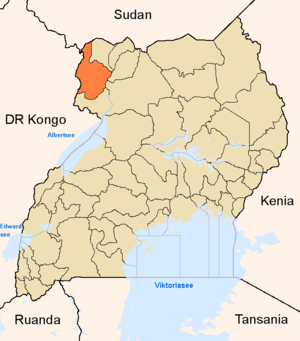
Arua district
| map | |
|---|---|
 Location of Arua |
|
| Basic data | |
| Capital | Arua |
| Geographical center | 3 ° 3 ' N , 31 ° 9' E |
| North South expansion | 127 km |
| East-west expansion | 84 km |
| population | 723,451 (as of 2002) |
| Time zone | UTC +3 |
| ISO 3166-2 | UG-303 |
Arua is a district ( district ) in northern Uganda with 855,055 inhabitants (2002). Like almost all districts of Uganda , it is named after its capital. On July 1, 2005, the northeastern part of Arua was split off and the new Koboko district was formed.
The Arua District is located in the far northwest of Uganda and borders the Democratic Republic of the Congo and South Sudan . Cross-border trade plays an important role in Arua's economy. Idi Amin , Ugandan dictator from 1971 to 1979, was born in Arua. During the Second Congo War, Ugandan forces reached the Democratic Republic of the Congo from Arua , where they took part in the plundering of the Congolese mineral resources. Arua itself is peaceful and was largely spared from the activities of the rebel army Lord's Resistance Army in northern Uganda.
economy
After the 1990s with little rain, with an annual rainfall average of just 274 millimeters and a dry year in 1999 as the low point, rain-fed agriculture was possible in the region between 2000 and 2009 . The average amount of rain, including the years 2003/2004, was 716 mm. The wettest year was 2001 with 1282 mm and the driest year 2007 with 410 mm. The tendency to torrential rain increased and culminated in the torrent of October 22, 2005 with 382 millimeters of precipitation.
In the region Arua falling Gros rain mostly in the second half. A dry January and a sparsely moist February are typical. The rain measurements from 1973 to 1978 only show a similar profile for 1978. This period only brings it to an annual average of 209 millimeters. From 1973 to 1977 Arua was plagued by a seemingly chronic drought .