Save
| Save | ||
|---|---|---|

|
|
|
| region | Grand Est | |
| Department | Moselle | |
| Arrondissement | Forbach-Boulay-Moselle | |
| Canton | Stiring coil | |
| Community association | Forbach Porte de France | |
| Coordinates | 49 ° 12 ′ N , 6 ° 58 ′ E | |
| height | 220-357 m | |
| surface | 8.11 km 2 | |
| Residents | 3,224 (January 1, 2017) | |
| Population density | 398 inhabitants / km 2 | |
| Post Code | 57350 | |
| INSEE code | 57659 | |
| Website | www.spicheren.fr | |
Spicheren (German Spichern ) is a French commune with 3224 inhabitants (as of January 1, 2017) in the Moselle department in the Grand Est region (until 2015 Lorraine ). It is located directly on the German-French border. The place became known in Germany and France because Spicheren was the scene of the battle of Spichern during the Franco-Prussian War of 1870/71.
geography
Spicheren is a town in the east of the Moselle department right on the Franco-German border. The German-French border crossing Goldene Bremm (French Brème d'or ) is located in the district of Spicheren.
Culture and language
The official language is French . As a colloquial language, German is still very widespread among the older population, especially in its form as Lothringer Platt . Due to the special quality of living and the proximity to the Saarbrücken metropolitan area , 30% of the residents of Spichern are German citizens . As part of a cross-border project, the children in preschool and elementary school have been taught bilingual German and French since 2005.
history
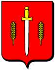
The name of the village, which was first mentioned in 1259, is derived from the Latin word "spicarium" for "granary" and this explains two ears of corn on the municipality's coat of arms. The sword that separates these two ears of corn is reminiscent of the Franco-German War (July 1870 to February 1871).
After the incorporation of Alsace-Lorraine in 1871, the Prussians erected five monuments on the so-called "Spicherer Heights". Two cemeteries commemorate the more than a thousand dead in the battle of Spicheren . In 1934, after the region had been part of France again since 1919, the 15-meter-high cross was erected in honor of the French soldiers who died on August 6, 1870.
Second World War
During the Second World War , the Spicherer Heights played a remarkable role in the German defense, because German troops were stationed there after French troops had withdrawn to the Maginot Line on French territory. From the perspective of the Nazi regime, the proximity to the industrial plants in Saarland and the large city of Saarbrücken near the border required the capture of the Giffertwald near Spicherns.
In December 1939, the first temporary shelters were built on the Spicherer Heights. On December 24, 1939, Adolf Hitler visited the positions on the Spicherer Heights. He was accompanied by Erwin von Witzleben , the commander in chief of the 1st Army . On the occasion of the first Christmas of the war, the bells of the Church of St Laurent von Spichern rang . One of the shelters was subsequently referred to as the "Adolf Hitler position". From January to June 1940, the Spichern position was built as part of the west wall . The bunkers of the Spichern position were not razed .
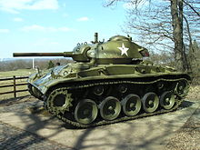
On February 21, 1945 soldiers of the 70th Infantry Division (" Trailblazers ") liberated the village. At the entrance to Spichern there is a German military cemetery , which was laid out in 1952 by the city of Saarbrücken to commemorate those who fell in 1940. An M24 Chaffee tank donated on May 8, 1997 by the veterans of the " Trailblazers " of the municipality of Spicheren reminds us of the horrors of the war.
Population development
| year | 1962 | 1968 | 1975 | 1982 | 1990 | 1999 | 2007 | 2017 |
| Residents | 2202 | 2355 | 2414 | 2593 | 3008 | 3287 | 3249 | 3224 |
church
The Church of St-Laurent was built in 1830.
Cross tail
A horseshoe-shaped valley called Kreuzheck, which includes a lot of fertile soil and is surmounted by a limestone ledge at a height of 157 meters, is a former limestone quarry.
As early as 1862, limestone was mined in the Spicherer Flur Kreeuteck and a lime kiln operated, which supplied glass kilns in Schœneck . In 1909, the Luxembourg company ARBED took over the quarry, the quarrying area, which was now expanded to nine hectares, extended to the municipal areas of Spicheren, Etzling and Alsting . ARBED also installed a five-kilometer-long cable car and used it to transport up to 500 tons of rock a day across the Saar to Bübingen in Germany. Up to 150 workers from the surrounding villages and Italian guest workers worked here until 1944.
Particularly favorable climatic conditions have encouraged a species-rich flora and fauna in the elongated pit . Today the tracks are covered with moss and ferns . There are several species of orchids and other plants that qualify the Kreuzheck area as a nature reserve.
In 1926, the remains of a rhinoceros were discovered in the quarry , as well as plant remains that suggest a prehistoric hunting camp .
traffic
Spicheren is located on Europastraße 50 , which is Federal Motorway 6 on the German side and Autoroute 320 on the French side . The N3 national road to Paris also begins in Spicheren . The German-French border crossing is called Goldene Bremm (French La Brême d'or).
literature
- Albert Ruppersberg: Saarbrücken war chronicle, events in and near Saarbrücken and St. Johann, as well as on the Spicherer Berge 1870, 4th edition, Leipzig 1911.
Web links
Individual evidence
- ^ Karl August Schleiden : Saarbrücken, as it was. Part 2, Düsseldorf, 1980, p. 32.
- ↑ Gerhild Krebs: The fortifications of the western wall in Saarland. memotransfont, accessed September 3, 2013 .
- ↑ see for example Arbeitsgemeinschaft Westwall
- ^ Rolf Wittenbrock: Former Battlefield Spichern. memotransfont, accessed September 4, 2013 .


