Brauweiler (Rhineland-Palatinate)
| coat of arms | Germany map | |
|---|---|---|

|
Coordinates: 49 ° 49 ' N , 7 ° 30' E |
|
| Basic data | ||
| State : | Rhineland-Palatinate | |
| County : | Bad Kreuznach | |
| Association municipality : | Kirner Land | |
| Height : | 323 m above sea level NHN | |
| Area : | 3.15 km 2 | |
| Residents: | 52 (Dec. 31, 2019) | |
| Population density : | 17 inhabitants per km 2 | |
| Postal code : | 55606 | |
| Area code : | 06754 | |
| License plate : | KH | |
| Community key : | 07 1 33 016 | |
| Association administration address: | Bahnhofstrasse 31 55606 Kirn |
|
| Website : | ||
| Local Mayor : | Karl-Jürgen Barth | |
| Location of the local community of Brauweiler in the Bad Kreuznach district | ||
Brauweiler is a municipality in the Bad Kreuznach district in Rhineland-Palatinate . It belongs to the Kirner Land association.
geography
The place is located in the southern Hunsrück at 323 meters above sea level on the western Soonvorstufe above the Kellenbach and the local community Simmertal .
history
Numerous prehistoric archaeological finds from different epochs testify that the area around the place was settled very early. The oldest finds date from the Younger Stone Age (3500–1800 BC).
The place name appears in 1380 as "Pruwilre" and goes back to the basic form "Brunen-wilre", which can be interpreted as the Hofgut of Bruno.
The village originally belonged to the large district simmering under Dhaun a spell basic rule of St. Maximin's Abbey in front of Trier , in which the Wild Count of Dhaun the Bailiwick right exercised.
In the late Middle Ages, Brauweiler was under the Koppenstein rule . The border location of the village within the Koppenstein office often led to disputes with the Wild and Rhine Counts based on Dhaun , because land and judicial rights were not precisely clarified. For example, it was argued from the Rhine Count's side that the Brauweiler municipality had neither its own district nor any rights outside of its spell fences, but that it shared water and pasture with the residents of Simmern under Dhaun. The Dhauner Wild- und Rheingraf also claimed the privilege of fishing, hunting and logging in the local area. This was disputed by the Palatinate Arbitration Court and it was decided that the Counts of Sponheim had granted these rights . Brauweiler remained part of the Koppenstein office until the end of the 18th century, which was subordinate to the Kirchberg regional office in Baden. In terms of church, Brauweiler was always assigned to the parish of Simmern under Dhaun .
After the French occupation of the area on the left bank of the Rhine and the territorial and administrative reform begun in 1798, Brauweiler was assigned to the Mairie Monzingen . Monzingen remained under the Prussian administration (after 1815) the seat of the mayor's office responsible for Brauweiler (renamed to office in 1927). After the dissolution of the Monzingen office, Brauweiler joined the Kirn-Land association from 1970 .
politics
Municipal council
The council in Brauweiler consists of six council members, who in the local elections on May 26, 2019 in a majority vote were elected, and the honorary mayor as chairman.
mayor
The local mayor is Karl-Jürgen Barth. In the local elections on May 26, 2019, he was confirmed in his office with 87.76% of the vote.
coat of arms
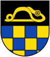
| Blazon : "Shield divided, above a golden brooch in black, below blue-gold boxed." | |
|
Foundation of the coat of arms: The robe brooch was found in 1936 during excavations in the Brauweiler district. It comes from the Latène period and shows a snake's body with a bird's head. The original is in the Roman-Germanic Central Museum in Mainz . The lower half of the shield refers to the former belonging to the front county of Sponheim .
The municipal council commissioned the graphic artist Brust, Kirnsulzbach, to develop a draft for a municipal coat of arms. At its meeting on August 12, 1977, the Council approved the draft presented. After approval by the State Archives , the Ministry of the Interior in Mainz granted on December 7, 1977 permission to use one's own coat of arms. |
Economy and Infrastructure
Brauweiler can only be reached via a spur road that branches off from the B 421 . The federal highway 41 runs in the south . In nearby Martinstein is a train station on the Bingen – Saarbrücken line .
See also
Web links
- Local community Brauweiler on the website of the association community Kirn-Land
- Brief portrait of Brauweiler on SWR television
- Literature about Brauweiler in the Rhineland-Palatinate state bibliography
Individual evidence
- ↑ State Statistical Office of Rhineland-Palatinate - population status 2019, districts, communities, association communities ( help on this ).
- ↑ a b Statistical Maps, Verbandsgemeinde Kirn-Land, 2009
- ^ The Regional Returning Officer RLP: City Council Election 2019 Brauweiler. Retrieved September 21, 2019 .
- ^ The regional returning officer RLP: direct elections 2019. see Kirn-Land, Verbandsgemeinde, third line of results. Retrieved September 21, 2019 .
- ^ Verbandsgemeinde Kirn-Land, the municipality coat of arms of Brauweiler


