Brauneberg
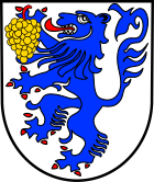
| coat of arms | Germany map | |
|---|---|---|

|
Coordinates: 49 ° 54 ' N , 6 ° 59' E |
|
| Basic data | ||
| State : | Rhineland-Palatinate | |
| County : | Bernkastel-Wittlich | |
| Association municipality : | Bernkastel-Kues | |
| Height : | 124 m above sea level NHN | |
| Area : | 12.22 km 2 | |
| Residents: | 1141 (Dec. 31, 2019) | |
| Population density : | 93 inhabitants per km 2 | |
| Postal code : | 54472 | |
| Area code : | 06534 | |
| License plate : | WIL, BKS | |
| Community key : | 07 2 31 012 | |
| LOCODE : | DE UBN | |
| Community structure: | 3 districts | |
| Association administration address: | Gestade 18 54470 Bernkastel-Kues |
|
| Website : | ||
| Local Mayor : | Werner Ruppenthal | |
| Location of the local community Brauneberg in the district of Bernkastel-Wittlich | ||
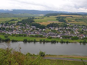
Brauneberg is a municipality on the Moselle near Bernkastel-Kues in the district of Bernkastel-Wittlich in Rhineland-Palatinate . It belongs to the community of Bernkastel-Kues and is best known for its wines and meteorological conditions. Until 1925 the name of the place was "Dusemond".
geography
Community structure
Brauneberg districts are Brauneberg, Filzen and Hirzlei.
The district of Hirzlei is located about five kilometers south of Brauneberg in the valley of the Frohnbach, there is no direct road that connects the two villages.
climate
In the Meteomedia - weather station Brauneberg-Juffer of Meteomedia was until then the highest ever measured in Germany temperature of 41.2 on 11 August 1998 ° C registered. Nevertheless, Brauneberg is not generally considered to be the heat pole of Germany and the record temperature is mainly due to its location on a slate mountain. The results of the weather station are therefore excluded from the official measurement.
history
Brauneberg was first mentioned in 588 AD. The old place name “Dusemond” may be traced back to “duos amandos montes super mosellam” (Latin for the two lovely mountains above the Moselle ). Contrary to the version that the name can be traced back to the “Duse” brook located between the districts of Brauneberg and Filzen, at whose confluence with the Moselle the place is located, speaks that “-mond” (confluence) comes from the Low German-speaking area, Dusemond itself but lies in the former central German area. Another version to explain the name Dusemond refers to the alleged Latin name of the Brauneberg as "dulcis mons" ("sweet mountain"). However, this declaration was only made around 1925, when the place was renamed Brauneberg. The reason for this was, among other things, the place name, which sounded too “French”, in the difficult times after the First World War (cf. Ruhr occupation ). The main idea behind this renaming, however, was probably to be able to apply the name of the well-known Brauneberg vineyard to the lesser-known and lower quality vineyards behind the town.
Dusemond belonged to the old county of Veldenz . Count Palatine Ludwig II and his successors introduced the Reformation . During the Thirty Years War , the Elector and Archbishop of Trier took possession of the place. Only in the Peace of Westphalia of 1648 was the Count of Veldenz reinstated in his old rights, which also made the parish of the place Protestant again. With the occupation of the County of Veldenz by France in 1680, the situation changed again and a dispute arose over the position of Catholics within the county. The French regulated the situation by decree on December 21, 1684: According to this, in towns with only one church - including the situation in Dusemond - this was intended for use by both denominations. The local church therefore became a simultaneous church . That only changed in 1955 when it was decided to divide the church and separate it structurally: 1/3 of the church has since been used by the Protestant community, 2/3 by the Catholics. This corresponds to the distribution of the original construction costs of the current church, completed in 1777.
The Simultankirche in Brauneberg itself was built from 1775 to 1777 according to plans by the Palatine court architect Franz Wilhelm Rabaliatti . The onion dome is the only church tower of its kind in the entire Moselle region. Even after the division of the church, it is still jointly owned by the two parishes.
Today's Brauneberg community was created on June 7, 1969 through the merger of the Brauneberg and Filzen communities.
- Population development
The development of the population of Brauneberg in relation to today's municipality area; the values from 1871 to 1987 are based on censuses:
|
|
Municipal council
The local council in Brauneberg consists of 16 council members, who were elected in a personalized proportional representation in the local elections on May 26, 2019 , and the honorary local mayor as chairman. The 16 seats in the local council are divided between three groups of voters .
Viticulture
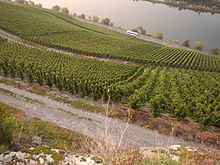
In addition to tourism, viticulture is the most important branch of the economy. The vines are mainly cultivated on the steep slope on around 323 hectares . Riesling is usually grown here; In addition, small quantities of Müller-Thurgau , Kerner and Dornfelder are produced in the flat and sloping areas .
The Brauneberg vineyards are part of the Kurfürstlay area and are divided into individual layers
- Almond pits
- The vines of the almond trench cover an area of 175 hectares. The name refers to almond trees that used to grow here.
- Monastery garden
- With 95 hectares, the monastery garden is the second largest vineyard in Brauneberg, the name is derived from the garden of the Franciscan monastery in the Filzen district.
- Juffer and Juffer Sundial
- The steep slope opposite the place Brauneberg is called "Juffer" (Moselle Franconian for Jungfer or Jungfrau). Within this location, the area around the sundial is regarded as a “fillet” and was given the name “Juffer Sundial”.
- This cultivation area of only 0.38 hectares is also located in the "Juffer" below a rocky promontory.
Historical
In 1868, under the direction of the Royal Cadastre Inspector, Steuerrath Clotten, a wine-growing map for the Trier administrative district was drawn up for the Royal Government of Trier. For the Brauneberg (Dusemond) area, the following individual layers are listed under the Brauneberg area:
- Rabbit runner
- chamber
- Falkenberg
- Juffer
- Mötschert
- Burgerslay
Well-known sons and daughters
- Ulli Bögershausen , internationally known solo guitarist and guitar teacher
- Johann Matthias Schreiber (1716–1771), German organ builder
- Julius Peter Heil (1876–1949), 30th Governor of Wisconsin, USA
See also
Web links
- Official website of the local church
- To search for cultural assets of the local community Brauneberg in the database of cultural assets in the Trier region .
Individual evidence
- ↑ State Statistical Office of Rhineland-Palatinate - population status 2019, districts, communities, association communities ( help on this ).
- ^ F. Schmitt: Chronicle of Brauneberg and Filzen . Brauneberg parish, 1988.
- ↑ Official municipality directory 2006 ( Memento from December 22, 2017 in the Internet Archive ) (= State Statistical Office Rhineland-Palatinate [Hrsg.]: Statistical volumes . Volume 393 ). Bad Ems March 2006, p. 172 (PDF; 2.6 MB). Info: An up-to-date directory ( 2016 ) is available, but in the section "Territorial changes - Territorial administrative reform" it does not give any population figures.
- ↑ State Statistical Office Rhineland-Palatinate - regional data
- ^ The Regional Returning Officer Rhineland-Palatinate: Local elections 2019, city and municipal council elections


