
Palas de Rei
| Palas de Rei municipality | |||
|---|---|---|---|
| coat of arms | Map of Spain | ||

|
|
||
| Basic data | |||
| Autonomous Community : | Galicia | ||
| Province : | Lugo | ||
| Comarca : | Ulloa | ||
| Coordinates | 42 ° 52 ′ N , 7 ° 52 ′ W | ||
| Area : | 199 km² | ||
| Residents : | 3,388 (Jan 1, 2019) | ||
| Population density : | 17.03 inhabitants / km² | ||
| Postal code : | 27200 | ||
| Municipality number ( INE ): | 27040 | ||
| administration | |||
| Mayor : | Fernando Alfredo Pensado Barbeira | ||
| Website : | www.palasderei.org | ||

Palas de Rei (Spanish: Palas de Rey ) is a place in the Spanish region of Galicia on the edge of the Camino de Santiago . It belongs to the province of Lugo and has 3388 inhabitants (as of January 1, 2019).
history

The place name literally means the royal palace . But there is no evidence to support the thesis that King Witiza held court here, nor that the place was the seat of a bishopric in the 5th century. The first recorded mention is in the Caelicolae of Alfons III . Aimeric Picaud also describes it as Palacium Regis in Jacob's Book . Another mention in the same place castigates prostitution, which is said to have existed at the time on the Camino de Santiago between Portomarín and Palas de Rei.
In Palas de Rei, the church of San Tirso mentioned in the Caelicolae is relevant to art history . In the municipality there are, however, a large number of Romanesque churches, the most important of which is the frescoed Salvador Church in Vilar de Donas . The castle of Pambre also belongs administratively to Palas de Rei.
Population development of the municipality
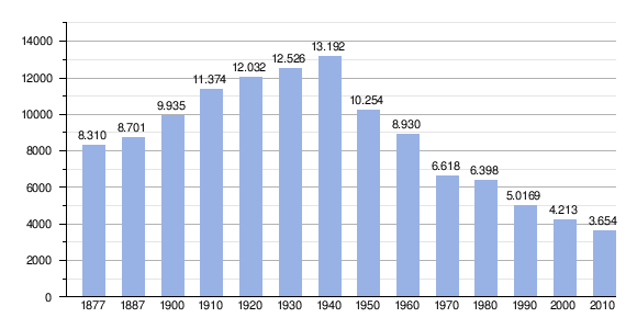
Source: INE archive - graphic processing for Wikipedia
literature
- Míllan Bravo Lozano: Practical pilgrim guide. The Camino de Santiago. Editorial Everest, Léon 1994, ISBN 84-241-3835-X , p. 221ff.
Web links
Individual evidence
- ↑ Cifras oficiales de población resultantes de la revisión del Padrón municipal a 1 de enero . Population statistics from the Instituto Nacional de Estadística (population update).
← Previous location: Ligonde 8.5 km | Palas de Rei | Next town: San Xulián do Camiño 3 km →
Abadín | Alfoz | Antas de Ulla | Baleira | Baralla | Barreiros | Becerreá | Begonted | Bóveda | Burela | Carballedo | Castro de Rei | Castroverde | Cervantes | Cervo | Chantada | O Corgo | Cospeito | Folgoso do Courel | A Fonsagrada | Foz | Friol | Guitiriz | Guntín | O Incio | Láncara | Lourenzá | Lugo | Meira | Mondoñedo | Monforte de Lemos | Monterroso | Muras | Navia de Suarna | Negueira de Muñiz | As Nogais | Ourol | Outeiro de Rei | Palas de Rei | Pantón | Paradela | O Páramo | A pastoriza | Pedrafita do Cebreiro | A Pobra do Brollón | Pole | A Pontenova | Portomarín | Quiroga | Rábade | Ribadeo | Ribas de Sil | Ribeira de Piquín | Riotorto | Samos | Sarria | O Saviñao | Sober | Taboada | Trabada | Triacastela | O Valadouro | O Vicedo | Vilalba | Viveiro | Xermade | Xove