
Gerlos Pass
| Gerlos Pass | |||
|---|---|---|---|
 Turn on the west ramp between Zell am Ziller and Gerlos |
|||
| Compass direction | east | west | |
| Pass height | 1531 m above sea level A. | ||
| state | Salzburg | Tyrol | |
| Watershed | Salzach , Inn ( Danube ) | Gerlosbach , Ziller , Inn | |
| Valley locations | Forest in Pinzgau | Zell am Ziller | |
| expansion | Gerlos Street (B165) | ||
| Mountains | Zillertal Alps / Kitzbühel Alps | ||
| profile | |||
| Ø pitch | 6.5% (646 m / 10 km) | 3.7% (956 m / 25.5 km) | |
| Max. Incline | 17% | 15% | |
| Map (Salzburg) | |||
|
|||
| Coordinates | 47 ° 14 '35 " N , 12 ° 6' 37" E | ||

The Gerlospass (also spelled Gerlos Pass ), also called Pinzgauer Höhe , is a road connection from Salzburg's Oberpinzgau to the Tyrolean Zillertal . The west ramp leads from Zell am Ziller via Gerlos to the top of the pass at 1531 m above sea level. A. . The east ramp then divides, the old pass road leads down to Wald im Pinzgau , while the newer Gerlos Alpine road starts at 1628 m above sea level. A. rises and then leads via Krimml to Wald im Pinzgau.
height
The altitude for the Gerlos Pass is 1531 m above sea level. A. for the top of the pass, which is shared by the old pass road and Gerlos Alpine road, and 1628 m above sea level. A. for the highest point of the Gerlos Alpine Road. Since the higher Gerlos Alpine Road is an optional route, the lower number is decisive.
Old pass road
The old pass road leading to the north ( 1531 m above sea level ) is closed to teams and trucks and is not always passable in winter. The old pass road is part of the Gerlos road (B165).
Gerlos Alpine Road
The new Gerlos Alpine Road to the south ( 1628 m above sea level ) was built in the 1960s by the Großglockner Hochalpenstraßen AG . In contrast to the old pass road, the Gerlos Alpine Road is well developed and can be used without restrictions all year round. The highest point of this new road, which runs along the slope north of the Gerlosplatte ski area , is located on the Salzburg side just under 4 km east of the deepest saddle. The crossing of the pass is subject to a toll for motor vehicles, the toll booth is located near the highest point.
The profiles for the Gerlos Alpine Road are as follows:
- from Wald im Pinzgau: 743 meters in altitude on a 10 km route with an average gradient of 7.4 percent and a maximum gradient of 9 percent
- From Zell am Ziller: 1053 meters in altitude on a 33.5 km route with an average gradient of 3.1 percent and a maximum gradient of 15 percent
The data in the info box refer to the old pass road.
Cycling
Both pass roads are often used by racing cyclists and sporty touring cyclists . On the old pass road, which is free of heavy traffic, steeper gradients have to be mastered than on the new pass road, but on the new pass road there is a total of more vertical meters to overcome. The Gerlos Pass is also used as part of cycling races , although the new pass road is usually used here for reasons of space. More recently, the Gerlos Pass has been crossed from Wald im Pinzgau as part of the Deutschland Tour 2008 (1st stage) and the Giro d'Italia 2009 (6th stage).
Surroundings
The Durlaßboden reservoir is located south of the Gerlos Pass , and the Krimml Waterfalls to the south-east .
photos
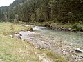
Gerlos pass, west ramp, Gerlosbach

West ramp, view of the Durlaßboden reservoir, in the background Plattenkogel (left) and Steinkarkopf (right)

West ramp, upland moor Gerlosplatte, in the background Rabenkopf and Achkogel
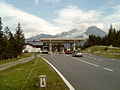
Gerlos Alpine Road, toll booth near the top of the pass

Turn in the east ramp between Krimml and the pass summit

East ramp, view of the Krimml waterfalls

Gerlos Pass, view from the Krimml Waterfalls

Gerlos Alpenstraße, top of the new pass road, looking east


See also
literature
- Steffan Bruns: Alpine passes - history of the alpine pass crossings . From the Danube to the Adriatic. 1st edition. tape 4 . L. Staackmann Verlag KG, Munich 2011, ISBN 978-3-88675-274-4 , p. 63-64 .
Web links
Individual evidence
Ahorn • Alpl • Ammer • Annaberg • Arlberg • Ascher • Bieler • Birkfelder • Boding • Brenner • Buchauer • Buchener • Dientner • Dürrholzer • Eibegg • Erb • Eisental • Faschina • Feistritz • Fern • Filzen • Flattnitz • Flexen • Forsthof • Furka • Fuscher • Gaberl • Gaden wide • Gailberg • Gangleit • Geiseben • Gerichtsberg • Gerlos • Geschriebenstein • Goller • Grießen • Griffner • Large Kripp • Grubberg • Grünbacher • Gschuett • Hafner • Hahntenn • neck • Haselrast • Hebalm • stallion • Hengstl • Hiaslegg • Hirschegger • Hochegger • Hochrindl • Hochtannberg • Hochtor • Holzleiten • Iselsberg • Josefsberg • Kaiserauer • Cold Kuchl • Kartitscher • Katsch • Kernhofer • Kerschbaumer • Klachauer • Klamm • Klamml • Small Kripp • Klippitz • Klostertaler • Kraxen • Kreuth • Kreuzberg • Kühtai • Lahn • Lienbach • Loibl • Losen • Luft • Mendling • Michelbühel • Moarigraben • Nassfeld • Neumarkter • Niederalpl • Norberts • Nöring • Obdacher • Oberjoch • Och • Pack • Paulitsch • Perchauer • Pfaffen • Pfarralm • Pielachtaler • Piller • Plöcken • Pogusch • Pölshals • Pötschen • Präbichl • Prebersattel • Preiner • Pretal • Promau • Pyhrn • Radl • Radling • Radstädter • Radstatt • Rams • Raneck • Rechberg • Rieder • Rohrer • Sattler • Saurüssel • Schaida • Schanz • Scharflinger • Schiestel • Schober • Schönfeld • Schwarze Sau • Schwarzenbichl • Seeberg • Seefelder • Semmering • Kleiner Semmering • Sieggraben • Silzer • Soboth • Summer • Staller • Styrian Seeberg • Straßegg • Sölk • Thurn • Timmels • Triebener Tauern • Turracher • Origin • Wechsel • Weinebene • Weißenbacher • Wagrainer • Windische • Wurzen • Zellerrain