
Puy-de-Dôme department
| Puy-de-Dôme | |
|---|---|
 |
  |
| region | Auvergne-Rhône-Alpes |
| prefecture | Clermont-Ferrand |
| Sub-prefecture (s) |
Ambert Issoire Riom Thiers |
| Residents | 653,742 (Jan. 1, 2017) |
| Population density | 82 inhabitants per km² |
| surface | 7,969.85 km² |
| Arrondissements | 5 |
| Community associations | 14th |
| Cantons | 31 |
| Communities | 464 |
|
President of the Department Council |
Jean-Yves Gouttebel |
| ISO-3166-2 code | FR-63 |
 Location of the department of Puy-de-Dôme in the region Auvergne Rhône-Alpes |
|
The Puy-de-Dome [ pɥiddoːm ] is the French department with the atomic number 63. It is in the center of the country in the region Auvergne Rhône-Alpes and after the volcanic Puy Dôme in the Massif Central named.
geography
The department borders the Allier department to the north, the Loire department to the east, the Haute-Loire and Cantal departments to the south and the Corrèze and Creuse departments of the Nouvelle-Aquitaine region to the west .
The department is located in the north of the Massif Central . The Allier , which runs from south to north, separates the Chaîne des Puys volcanic cone chain to the west from the eastern mountain ranges in the Livradois-Forez Regional Nature Park . The highest mountain of the Chaîne des Puys is 1465 m, the Puy de Dôme, which gives the department its name . Between Puy de Dome and Allier, the capital of Clermont-Ferrand is located in the middle of the department . To the southwest of Clermont-Ferrand lies the mountain range of the Monts Dore with the Puy de Sancy as the highest point of the Massif Central (1885 m). The Dordogne rises in the Monts Dore and leaves the department to the southwest, where it forms part of the border with the Corrèze department. The entire area from the Chaîne des Puys to the southwestern border with the Cantal department is part of the Volcans d'Auvergne Regional Nature Park . In the border area to the southwest lies the Artense granite plateau , to the south the Cézallier mountainous region .
In the east of the department, the Dore runs northwards as the right tributary of the Alliers, while the Sioule drains north-west as the left tributary of the Alliers.
history
The department was formed during the French Revolution on March 4, 1790 from a part of the then existing province of Auvergne .
There is the following anecdote about the naming: When the old provinces were to be replaced by the new divisions into regions and departments in 1790, people wavered between Mont-Dore (after Mont d'Or, a place in the area according to the spelling at the time German "Goldberg") and the name Puy-de-Dôme. The main reason was the fear that such a valuable name would be taxed a lot higher.
It was divided into eight districts ( French: district ), the forerunners of the arrondissements . The districts were Ambert, Besse, Billom, Clermont-Ferrand, Issoire, Montaigut, Riom and Thiers. The department and the districts were subdivided into cantons and had about 480,000 inhabitants (?). The capital was already Clermont-Ferrand at that time .
The arrondissements were established on February 17, 1800. They were Ambert , Clermont-Ferrand , Issoire , Riom and Thiers .
From September 10, 1926 to June 1, 1942, the Arrondissement Ambert was dissolved, the area belonged to the Arrondissement Thiers at that time.
From 1960 to 2015 it was part of the Auvergne region that became part of the Auvergne-Rhône-Alpes region in 2016 .
Cities
The most populous municipalities in the Puy de Dôme department are:
| city | Population (2017) |
Arrondissement |
|---|---|---|
| Clermont-Ferrand | 143,886 | Clermont-Ferrand |
| Cournon-d'Auvergne | 20,043 | |
| Riom | 19,180 | Riom |
| Chamalières | 17.173 | Clermont-Ferrand |
| Issoire | 14,822 | Issoire |
| Thiers | 11,847 | Thiers |
| Pont-du-Château | 11,441 | Clermont-Ferrand |
| Beaumont | 10,787 | |
| Gerzat | 10,365 | |
| Aubière | 10,061 |
Administrative division

The Puy-de-Dôme department is divided into five arrondissements , 31 cantons and 464 communes :
| Arrondissement | Cantons | Communities | Residents January 1, 2017 |
Area km² |
Density of population / km² |
Code INSEE |
|---|---|---|---|---|---|---|
| Ambert | 2 | 58 | 27,583 | 1,229.82 | 22nd | 631 |
| Clermont-Ferrand | 17th | 74 | 355.966 | 912.69 | 390 | 632 |
| Issoire | 5 | 133 | 77,963 | 2,268.45 | 34 | 633 |
| Riom | 10 | 155 | 135.843 | 2,705.38 | 50 | 634 |
| Thiers | 4th | 44 | 56,387 | 853.51 | 66 | 635 |
| Puy-de-Dôme department | 31 | 464 | 653.742 | 7,969.85 | 82 | 63 |
See also:
- List of communes in the Puy-de-Dôme department
- List of cantons in the Puy-de-Dôme department
- List of associations of municipalities in the Puy-de-Dôme department
- Dolmen and menhirs in the Puy-de-Dôme department
Photo gallery

Headquarters of the department administration in Clermont-Ferrand

Resistance memorial Puy-de-Dôme
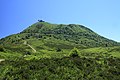
The Puy de Dôme volcano

The Puy de Sancy .


literature
- Johannes Baier (2020): The Chaîne des Puys in the Auvergne. - Fossils 37 (2): 46-56.
Web links
- Department of Puy-de-Dôme (French)
- Prefecture of the Puy-de-Dôme department (French)
Individual evidence
- ↑ cg63.fr ( Memento of the original from May 18, 2015 in the Internet Archive ) Info: The archive link was inserted automatically and has not yet been checked. Please check the original and archive link according to the instructions and then remove this notice. accessed on May 10, 2015.
01 Ain | 02 Aisne | 03 Allier | 04 Alpes-de-Haute-Provence | 05 Hautes-Alpes | 06 Alpes-Maritimes | 07 Ardèche | 08 Ardennes | 09 Ariège | 10 Aube | 11 Aude | 12 Aveyron | 13 Bouches-du-Rhône | 14 Calvados | 15 Cantal | 16 Charente | 17 Charente-Maritime | 18 Cher | 19 Corrèze | 21 Côte-d'Or | 22 Côtes-d'Armor | 23 Creuse | 24 Dordogne | 25 Doubs | 26 Drôme | 27 Your | 28 Eure-et-Loir | 29 Finistère | 30 Gard | 31 Haute-Garonne | 32 Gers | 33 Gironde | 34 Hérault | 35 Ille-et-Vilaine | 36 Indre | 37 Indre-et-Loire | 38 Isère | 39 Jura | 40 Landes | 41 Loir-et-Cher | 42 Loire | 43 Haute-Loire | 44 Loire-Atlantique | 45 Loiret | 46 Lot | 47 Lot-et-Garonne | 48 Lozère | 49 Maine-et-Loire | 50 Some | 51 Marne | 52 Haute-Marne | 53 Mayenne | 54 Meurthe-et-Moselle | 55 Meuse | 56 Morbihan | 57 Moselle | 58 Nièvre | 59 North | 60 Oise | 61 Orne | 62 Pas-de-Calais | 63 Puy-de-Dôme | 64 Pyrénées-Atlantiques | 65 Hautes-Pyrénées | 66 Pyrénées-Orientales | 67 Bas-Rhin | 68 Haut-Rhin | 69D Rhône | 69M Métropole de Lyon (from 2015) | 70 Haute-Saône | 71 Saône-et-Loire | 72 Sarthe | 73 Savoie | 74 Haute-Savoie | 75 Paris (from 1968) | 76 Seine-Maritime | 77 Seine-et-Marne | 78 Yvelines (from 1968) | 79 Deux-Sèvres | 80 Somme | 81 Tarn | 82 Tarn-et-Garonne | 83 Var | 84 Vaucluse | 85 Vendée | 86 Vienne | 87 Haute-Vienne | 88 Vosges | 89 Yonne | 90 Territoire de Belfort | 91 Essonne (from 1968) | 92 Hauts-de-Seine (from 1968) | 93 Seine-Saint-Denis (from 1968) | 94 Val-de-Marne (from 1968) | 95 Val-d'Oise (from 1968)
Overseas Departments (DOM)
971 Guadeloupe |
972 Martinique |
973 French Guiana |
974 Réunion |
976 Mayotte
Départements
20 Corse
dissolved after 1962 (until 1975) | 2A Corse-du-Sud (1976-2017) |
2B Haute-Corse (1976-2017) |
75 Seine (until 1967) |
78 Seine-et-Oise (until 1967)
Coordinates: 45 ° 42 ' N , 3 ° 11' E