
Nordhastedt
| coat of arms | Germany map | |
|---|---|---|

|
Coordinates: 54 ° 10 ' N , 9 ° 11' E |
|
| Basic data | ||
| State : | Schleswig-Holstein | |
| Circle : | Dithmarschen | |
| Office : | Parish Landgemeinde Heider Umland | |
| Height : | 11 m above sea level NHN | |
| Area : | 26.56 km 2 | |
| Residents: | 2827 (Dec. 31, 2019) | |
| Population density : | 106 inhabitants per km 2 | |
| Postal code : | 25785 | |
| Area code : | 04804 | |
| License plate : | HEI, MED | |
| Community key : | 01 0 51 082 | |
| LOCODE : | DE 68P | |
| Office administration address: | Kirchspielsweg 6 25746 Heide |
|
| Website : | ||
| Mayor : | Klaus-Peter Tiessen ( CDU ) | |
| Location of the municipality of Nordhastedt in the Dithmarschen district | ||
 |
||

Nordhastedt is a municipality in the Dithmarschen district in Schleswig-Holstein .
geography
location
The community is centrally located in the district, the nearest town is Heide . The community lies in the Heide-Itzehoer Geest and is therefore hilly. The lowest point is in the moorland at 0.2 meters above sea level, the highest at 67 meters above sea level. The district of Fiel is home to the Fieler Moor nature reserve .
Community structure
The municipality includes the districts of Fiel, Osterwohld and Westerwohld as well as the settlements of Lübschen, Nordhastedterfeld and Riese. It is on the edge of the Riesewohlds , the largest Dithmarsch forest. A brick factory was in operation in Westerwohld until 1840.
Neighboring communities
Neighboring communities are the city of Heide and the communities of Gaushorn , Schrum , Arkebek , Odderade and Sarzbüttel , the city of Meldorf and the community of Hemmingstedt (all in the district of Dithmarschen), starting clockwise in the northwest .
history
Nordhastedt is first mentioned as Herstide in 1140 and in another source in 1168. In 1281 the parish of Herstede exists. The church in Nordhastedt is mentioned under the name Repherstede in a directory of the Propstei Hamburg from 1347.
In 1506 Nordhastedt was hit hard by the plague.
In Nordhastedt-Westerwohld there was a powder mill until 1578, then a water mill. The Katharinenkirche, whose origins date back to the 14th century, is also a listed building, as is the oldest surviving residential building from 1812. Old knick harps in Osterwohld are listed as natural monuments. The community was awarded several times in the competition "Our village should be more beautiful" .
On April 1, 1934, the parish of Nordhastedt was dissolved. All of their villages, village communities and farmers became independent communities / rural communities, including their main town, Nordhastedt.
Population numbers
- 1855: 607 inhabitants
- 1875: 977 inhabitants
- 1885: 1027 inhabitants
- 1895: 1058 inhabitants
- 1905: 1182 inhabitants
- 1925: 1339 inhabitants
- 1939: 1379 inhabitants
- 1950: 2572 inhabitants
- 1961: 1840 inhabitants
- 1970: 1900 inhabitants
Incorporations
On April 1, 1936, Osterwohld and Westerwohld were incorporated. Both communities were independent for two years after the dissolution of the parish land community.
On January 1, 1974, the previously independent municipality of Fiel was incorporated.
politics
Of the 19 seats in the municipal council, the CDU has had nine seats since the 2013 local elections, the SPD four and the electoral groups BfN and UWN have three seats each.
coat of arms
Blazon : "Argent, a armed with a precipitated halberd, with bare feet in shallow water wading female figure in Altdithmarscher costume with goldgesäumtem, golden belted green skirt with rich golden chest ornament and red, decorated with a broad golden button band Kagel ."
Economy and Infrastructure
The economic importance of the municipality of Nordhastedt is characterized by traditional agriculture, small-town and rural handicrafts. The infrastructure is supported by the supermarket, the country bakery, the two restaurants, an ice cream parlor, the two bank branches, the family doctor's practice, the dentist's practice and the veterinary practice.
traffic
Nordhastedt is located on the Büsum – Heide (Holstein) –Neumünster railway line operated by the Nordbahn Railway Company , with stops every two hours in both directions. There are regular bus services to Albersdorf (Holstein) , Heide (Holstein) , Meldorf and Neumünster .
culture and education
In the community there is a primary school, the Maria-Jessen-Schule , supported by a private association, and two kindergartens, which were expanded by a new building in 2016, the Ev. Katharinen kindergarten and a forest kindergarten. The village has its own adult education center with a library in the Ole Schriewerie community center . Numerous art and music events as well as lectures take place there. Right next to it - in the middle of the village - there are references to the forest nature trail at the outdoor pool.
swimming pool
The municipality of Nordhastedt operates a solar-heated outdoor pool as a public facility, supported by the private sponsorship association Waldschwimmbad. In front of the outdoor pool, the mill pond invites you to go pedal boating and hiking. See also the historical picture of the outdoor pool Nordhastedt Mühlenteich around 1920.
Hiking trails Nordhastedt
Nordhastedt has beautiful hiking trails. Around Nordhastedt lies the largest closed forest area in the Dithmarschen district, partly a nature reserve. Seven designated hiking trails with 25 km of hiking make Nordhastedt attractive for residents, Dithmarschers and tourists.
Sports
Multi-purpose hall in passive house construction, 2 sports fields (lawn sports field at the school or multi-purpose hall and lawn sports field Merjenhemmsweg, each tournament size)
Monuments
The list of cultural monuments in Nordhastedt includes the cultural monuments entered in the list of monuments of the state of Schleswig-Holstein.
Regular events
Blackberry
The Frunsbeer (women's festival) celebrated in Nordhastedt goes back to a legend from the 16th century. One in giant Wohld Dwelling and stray gang of robbers to time without the active help of Mary Jessen (now also arms figure in the community), and repulsed the North Hastedter women with the help of kitchen appliances and boiling porridge, overwhelmed and have been partially strung up in giant Wohld. This event is honored every three years. The festival begins with an open-air play in which the “historical” scene is re-enacted in original costume. This is followed by a parade through the place decorated with oak leaves and a final evening dance event. In the marquee, a slipper hangs under the ceiling as a sign that the women are in charge that evening. On this evening no man is allowed to turn down a dance to which he is asked by a woman.
Christmas Market
The Nordhastedter Christmas market has been held every 2nd Advent in the large multi-purpose hall since 2014.
Care for people with disabilities
Herbert Feuchte Foundation Association
There are two residential facilities in Nordhastedt that offer support and care for multi-handicapped hearing-impaired and deaf-blind adults. The Herbert Feuchte Stiftungsverbund gGmbH is responsible for these institutions. Equipping the Nordhastedt train station with touch stones helps to break down everyday barriers for people with disabilities.
Personalities associated with Nordhastedt
- Elisabeth Hablik-Lindemann (* 1879 in Wester Wohld as Abeline Elisabeth Lindemann , † 1960 in Itzehoe ), German Lady Artist , weavers champion and Bildwirkerin
- Hans Kummerfeldt (* 1887 in Boizenburg , † 1963 in Nordhastedt), master blacksmith and politician (NSDAP)
- Friedrich Wiese (* 1892 in Nordhastedt, † 1975 in Gießen ), infantry general in the Wehrmacht
photos

Heraldic figure of the community: Maria Jessen, sculpture made of sheet metal, on the roundabout towards Heide or Albersdorf (2017)

Nordhastedt towards Westerwohld

Historic picture: Nordhastedt Central Garden around 1911

25785 Nordhastedt Bahnhofstrasse around 1917

The Katharinenkirche in Nordhastedt

Historical picture: Nordhastedt old municipal administration building from 1908

Nordhastedt swimming pool Riesewohld 1970

"Ole Schriewerie" in Nordhastedt with a library, adult education center, registry office and mayor's office

Nordhastedt primary school Maria-Jessen-Schule
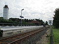
Nordhastedt station of the regional train, renovated in 2013
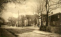
Historic picture: Hauptstrasse Nordhastedt around 1900
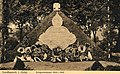
Historic picture: Nordhastedt Memorial First World War 1914–1918

Historic picture: Nordhastedt summer inn E. Reimers 1912

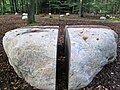
Nordhastedt-Fiel: Cenotaph for the war dead of the First World War. Boulder with an eagle and an iron cross. Additional panels for those killed in the Second World War
New forest cemetery 2013 Nordhasted-Osterwohld

Forest cemetery of the Lindemann / Kruse families with the grave of Wenzel Hablik in Nordhastedt-Westerwohld

Historic picture: outdoor pool Nordhastedt Mühlenteich around 1920
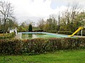
Today's solar-heated outdoor pool in Nordhastedt

Sports and multi-purpose hall in Nordhastedt with spectator stands and standard competition size (multi-field hall)

The minstrel and fanfare parade of TSV Nordhastedt (founded in 1966) also performed at the Steubenparade in New York

Old fish ladders in brooks to the water mill Nordhastedt-Westerwohld
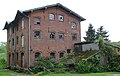
Watermill (1652) in Nordhastedt-Westerwohld
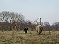
Free-ranging Galloway cattle herd from the Nature Conservation Foundation in Nordhastedt-Westerwohld
Natural pasture from the Nature Conservation Foundation in Nordhastedt-Westerwohld

Nature reserve Fieler See and Fieler Moor, 255 ha with signposted circular hiking trails

Thousands of wild geese overwinter between Nordhastedt-Fiel-Hemmingstedt
The history of the Frunsbeerfest in Nordhastedt

Many storks nest in and around Nordhastedt. Nature is still fine there, the agricultural meadows feed the storks very well

Wild orchids in the forest area Nordhastedt-Westerwohld (speckled orchid (Dactylorhiza maculata), also spotted fingerroot, from the orchid family (Orchidaceae))

Pure nature: beautiful old forest, forest area Nordhastedt-Westerwohld


.jpg)
.jpg)
Web links
Individual evidence
- ↑ North Statistics Office - Population of the municipalities in Schleswig-Holstein 4th quarter 2019 (XLSX file) (update based on the 2011 census) ( help on this ).
- ↑ Schleswig-Holstein topography. Vol. 7: Munkbrarup - Pohnsdorf . 1st edition Flying-Kiwi-Verl. Junge, Flensburg 2006, ISBN 978-3-926055-88-0 , p. 169 ( dnb.de [accessed on July 22, 2020]).
- ^ Henning Oldekop: Topography of the Duchy of Holstein. Including the Duchy district ... Lipsius & Tischer, Kiel 1908.
- ↑ a b J. Hanssen, H. Wolf: Chronik des Landes Dithmarschen. Langhoff, Hamburg 1833. (Reprint: Verlag British Lib Historical, 2014, ISBN 978-1-241-53704-3 )
- ↑ State Statistical Office Schleswig-Holstein (ed.): The population of the communities in Schleswig-Holstein 1867 - 1970 . State Statistical Office Schleswig-Holstein, Kiel 1972, p. 250 .
- ^ Federal Statistical Office (ed.): Historical municipality directory for the Federal Republic of Germany. Name, border and key number changes in municipalities, counties and administrative districts from May 27, 1970 to December 31, 1982 . W. Kohlhammer, Stuttgart / Mainz 1983, ISBN 3-17-003263-1 , p. 181 .
- ↑ Schleswig-Holstein's municipal coat of arms
- ↑ Friends of the Maria-Jessen-Schule Grundschule Nordhastedt
- ↑ Associations of the municipality of Nordhastedt, Amt Kirchspielslandgemeinde Heider Umland ( memento of the original dated May 9, 2014 in the Internet Archive ) Info: The archive link was automatically inserted and not yet checked. Please check the original and archive link according to the instructions and then remove this notice.
- ↑ Associations of the municipality of Nordhastedt, Amt Kirchspielslandgemeinde Heider Umland ( memento of the original dated May 9, 2014 in the Internet Archive ) Info: The archive link was automatically inserted and not yet checked. Please check the original and archive link according to the instructions and then remove this notice.
- ↑ Description, technical data and dimensions of the multi-purpose hall ( Memento of the original from May 25, 2014 in the Internet Archive ) Info: The archive link was inserted automatically and has not yet been checked. Please check the original and archive link according to the instructions and then remove this notice.

Cities: Brunsbüttel | Büsum | Heather | Marne | Meldorf | Wesselburen
Other communities: Albersdorf | Arkebek | Averlak | Bargenstedt | Barkenholm | Barlt | Berggewöhrden | Brickling | Buchholz | Bunsoh | Castle (Dithmarschen) | Busenwurth | Büsumer Deichhausen | Dellstedt | Delve | Diekhusen-Fahrstedt | Things | Dörpling | Eddelak | Eggstedt | Elpersbüttel | Epenwöhrden | Fedderingen | Frestedt | Friedrichsgabekoog | Friedrichskoog | Gaushorn | Glüsing | Great Wheel | Groven | Gudendorf | Hedwigenkoog | Hellschen-Herringand-Unterschaar | Helse | Inhibit | Hemmingstedt | Hennstedt | Hillgroven | Hochdonn | Hollingstedt | Hövede | Immenstedt | Kaiser-Wilhelm-Koog | Karolinenkoog | Kleve | Clutter | Kronprinzenkoog | Krumstedt | Kuden | Lehe | Lieth | Linden | Lohe-Rickelshof | Lunden | Marnerdeich | Neuenkirchen | Neufeld | Neufelderkoog | Nindorf | North dike | Norderheistedt | Nordermeldorf | Norderwöhrden | Nordhastedt | Odderade | Oesterdeichstrich | Oesterwurth | Offenbüttel | Easter wheel | Ostrohe | Pahlen | Quickborn | Ramhusen | Rehm-Flehde-Bargen | Reinsbüttel | Saint Anne | Sankt Michaelisdonn | Sarzbüttel | Schafstedt | Schalkholz | Schlichting | Schmedeswurth | Schrum | Schülp | Place-Wittenwurth | Strübbel | Süderdeich | Süderdorf | Süderhastedt | Süderheistedt | Tellingstedt | Tensbüttel roast | Tielenhemme | Trennewurth | Volsemenhusen | Wallen | Warwerort | Weddingstedt | Welmbüttel | Wennbüttel | Wesselburener Deichhausen | Wesselburenerkoog | Wesseln | Westerborstel | Westerdeichstrich | Wiemerstedt | Wind mountains | Woehrden | Wolmersdorf | Wrohm