
Lukmanier Pass
| Lukmanier Pass | |||
|---|---|---|---|
 Hospice with Lai da Sontga Maria and the side valley to the Val Rondadura lake, above it Piz Lai Blau as the highest point on the horizon |
|||
| Compass direction | north | south | |
| Pass height | 1915 m above sea level M. | ||
| Canton | Grisons | Ticino | |
| Watershed | Medelser Rhein → Vorderrhein | Brenno - Ticino → Po | |
| Valley locations | Disentis | Biasca | |
| expansion | Street | ||
| Built | 1877 | ||
| Winter closure | Open all year round, closed at night in winter, and from midday in spring | ||
| profile | |||
| Ø pitch | 3.7% (784 m / 21.2 km) | 4% (1613 m / 40.8 km) | |
| Max. Incline | 9% | 9% | |
| map | |||
|
|||
| Coordinates | 704 443 / 157739 | ||

The Lukmanier Pass ( Italian Passo del Lucomagno , Rhaeto-Romanic ), 1915 m above sea level. M. , is a Swiss Alpine pass on the border between the cantons of Graubünden (municipality of Medel ) and Ticino (village of Olivone in the municipality of Blenio). The name is derived from the Latin lucus magnus , the "great forest".
geography
The approach leads from Disentis through the Val Medel to the top of the pass. After the construction of the Santa Maria dam , the traffic routes had to be relocated; Hikers can bypass the lake on the west side and when crossing the Val Rondadura climb higher than the pass up to 1942 meters, while the culmination point of the road even to 1972 m above sea level. M. is in the gallery north of the pass summit. Head south through the Blenio Valley to Biasca . The Lukmanier Pass separates the Gotthard massif from the Adula Alps . The European watershed runs along the Lukmanier Pass . Interestingly, the water of the Val Cadlimo , located south of the main Alpine ridge , flows as the Medels Rhine towards the North Sea within sight of the pass . The Lukmanier Pass offers the only way to cross the Swiss Alps by car (in the sense of a north-south crossing) without exceeding an altitude of 2000 meters.
history

The discovery of a Roman coin treasure near Malvaglia indicates that the pass was already crossed at that time. It experienced its first heyday in the Franconian Empire when the Disentis Monastery was founded at the beginning of the 8th century . In the High and Late Middle Ages , especially at the time of the Staufer , the Lukmanier was considered the most important north-south connection in Switzerland, then lost this role to the Gotthard and Splügen Pass , which compensate for the disadvantage of the 200 m higher culmination with more direct lines. 1374 the monastery built a the sacred below the summit Maria consecrated hospice . In 1964 the hospice and chapel had to give way to the reservoir. Both were rebuilt on the pass road. The new hospice was inaugurated on August 1, 1965. The construction of the chapel was financed by the NOK , it was consecrated in 1967.
In the middle of the 19th century, when choosing the route for an Alpine railway between German-speaking Switzerland and Ticino, the Lukmanier route, which would have done without an expensive summit tunnel, was chosen in favor of the Gotthard Railway through the Reuss Valley and the Leventina in 1869 . Although a modern road over the Lukmanier was opened in 1872 (Graubünden) and 1877 (Ticino), the importance of the pass, which had finally become obsolete as a supraregional transport axis due to the construction of the Gotthard motorway with the Gotthard road tunnel opened in 1980 . In connection with the construction of the Lai da Sontga Maria reservoir of the Vorderrhein power plants on the Grisons side, the street was relocated to a gallery in the 1960s.
From 1877 to 1950, almost no renovations or changes were made to the Lukmanierpassstrasse. From 1950 to 1972 the street was widened and partly rebuilt. The Lukmanier Pass was closed in winter even with the newly built road. In the years 1963–1967 a new dam was built for the Lag da Sontga Maria reservoir. In the years 1956–1990, the Swiss Army organized snow removal every winter.
On July 15, 1967, an interest group consisting of representatives of the Cadi and the Blenio Valley was formed with the aim of opening the pass road all year round. This working group, called “Pro Lucmagn”, disbanded after only one year of intensive work. Two major councils of the Cadi district took up this matter again in 1997. At the initiative of National Councilor Walter Decurtins from Trun and Grand Councilor Gion Schwarz from Disentis, the Pro Lucmagn association was formed again and the governments of the cantons of Graubünden and Ticino signaled their support.
On August 18, 2000, the Pro Lucmagn association was founded. The main task of this association is to keep the Lukmanier Pass open in winter. The two cantons of Ticino and Graubünden contributed to the estimated costs of 750,000 Swiss francs from the start, but they did not want to take over the organization. After a five-year trial phase, the work and safety were evaluated on the pass road in the winter half-year. The experiences made were so good that the Lukmanier Pass was kept open. On May 20, 2009, the councilors of the Canton of Ticino and Graubünden, Marco Borradori and Stefan Engler, decided to open the Lukmanier Pass in winter for an indefinite period.
Varia
The Central Kraftwerke took advantage of the low pass for the construction of the Lukmanier line , a 380 kV high voltage line over the Alps. Since the pipeline is older than the reservoir, a mast was placed on 28-meter-high concrete stilts in the middle of the lake - there was no need to lay the pipeline, which was costly and requiring a permit.
From the pass you can hike over the Passo dell 'Uomo ( 2218 m above sea level ) into the Val Piora , at the end of which is the Lago Ritóm reservoir .

Lukmanier, still without a lake, historical aerial photo from 1923, taken from a height of 2000 meters by Walter Mittelholzer

A bridge over the old Lukmanierstrasse, which is no longer used today

Figure of Mary above the hospice

Alp "Piano" on the south side

View from the western flank of Scopí to the top of the pass
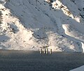
Mast of the high voltage line in the lake


literature
- Sonia Fiorini: Lukmanier Pass. In: Historical Lexicon of Switzerland . May 31, 2012 .
Web links
Individual evidence
- ↑ Münzschatz under objects 1986 on the website Sammellust Tirol (sammellust.ferdinandeum.at)
- ↑ Horst Johannes Tümmers: The Rhine: A European river and its history (p. 35) . 2nd Edition. CH Beck, 1999, ISBN 978-3-406-44823-2 .
- ↑ Lukmanierpass on alpenspass.ch accessed on July 1, 2016
- ↑ Giger, Ciprian .: People, avalanches and stories on the Lukmanier Pass: 60 years of winter service: 1955–2015 . Ciprian Giger, Pardé 2016, ISBN 978-3-9524686-0-9 .
Ächerli • Agites • Aiguillon • Albis • Albula • Balmberg • Benkerjoch • Bernina • Böhler • Bözberg • Breitehöchi • Brünig • Buechenegg • Bürersteig • Chall • Challhöchi Pass • Champex • Chasseral • Chatzenstrick • Chilchzimmersattel • Croix • Croix • Croix de Coeur • Eichhöhe • Étroits • Etzelpass • Flüela • Forclaz • Furka • Ghöch • Givrine • glass • Glaubenberg • Glaubenbielen • Gottschalkenberg • Grimsel • Grosse Scheidegg • Gr.St.Bernhard • Gurnigel • Haggenegg • Hahnenmoos • Heitersberg • Hilferen • Hirzel • Hirzel Höhi • Hulftegg • Ibergeregg • Jaman • Jaun • Julier • Kerenzerberg • Klausen • Kunkels • Lein • Lenzerheide • Livigno • Lukmanier • Maloja • Marchairuz • Mollendruz • Mont Crosin • Monte Ceneri • Mont d'Orzeires • Montvoie • Morgins • Mosses • Mutschellen • Neggia • Nufenen • Oberalp • upper Hauenstein • Oberricken • oven • Orn • Passwang • Pierre Pertuis • Pillon • Planches • Pontins • Pragel • edge crossing • Rangiers • rates • Rengg • crocheted • Roches • 'groups • R üsler • Saanenmöser • Salhöhe • San Bernardino • Sanetsch • Santelhöchi • Sattel • Sattelegg • Schafmatt • Schallenberg • Schelten • Schönau • Schufelberger Egg • Schwägalp • Schwarzenbühl • Siblingerhöhe • Simplon • Splügen • St. Anton • St. Gotthard • St. Luzisteig • Staffelegg • Stoss • Susten • Tourne • Tronc • Umbrail • Unterer Hauenstein • Front Höhi • Vue des Alpes • Wasserfluh • Weissenstein • Wildhaus • Wissegg • Wolfgang