
Pamproux
| Pamproux | ||
|---|---|---|
.svg)
|
|
|
| region | Nouvelle-Aquitaine | |
| Department | Deux-Sèvres | |
| Arrondissement | Niort | |
| Canton | Celles-sur-Belle | |
| Community association | Haut Val de Sèvre | |
| Coordinates | 46 ° 24 ′ N , 0 ° 3 ′ W | |
| height | 77-183 m | |
| surface | 36.3 km 2 | |
| Residents | 1,747 (January 1, 2017) | |
| Population density | 48 inhabitants / km 2 | |
| Post Code | 79800 | |
| INSEE code | 79201 | |
| Website | http://www.pamproux.fr/ | |

Pamproux is a French commune with 1,747 inhabitants (as of January 1 2017) in the department of Deux-Sèvres in the region Nouvelle-Aquitaine . It belongs to the Arrondissement of Niort and the canton of Celles-sur-Belle (until 2015: canton of La Mothe-Saint-Héray ). The inhabitants are called Pamprousien (ne) s .
geography
Pamproux is about 35 kilometers southwest of Poitiers . Pamproux is surrounded by the neighboring communities of Saint-Germier in the north, Rouillé in the east, Avon in the south-east, Bougon in the south, Salles in the west and south-west and Soudan in the west and north-west.
The A10 car route runs along the north-western edge of the municipality .
Population development
| year | 1962 | 1968 | 1975 | 1982 | 1990 | 1999 | 2006 | 2012 |
| Residents | 1,717 | 1,708 | 1,737 | 1,736 | 1,728 | 1,626 | 1,649 | 1,681 |
| Source: Cassini and INSEE | ||||||||
Attractions
- Saint-Maixent Church, Monument historique
- Market hall, Monument historique

Saint-Maixent church
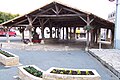
Market hall

.JPG)
Web links
Commons : Pamproux - collection of images, videos and audio files