
Paulin (Dordogne)
|
Paulin Paulinh |
||
|---|---|---|
|
||
| region | Nouvelle-Aquitaine | |
| Department | Dordogne | |
| Arrondissement | Sarlat-la-Canéda | |
| Canton | Terrasson-Lavilledieu | |
| Community association | Pays de Fénelon | |
| Coordinates | 45 ° 0 ′ N , 1 ° 21 ′ E | |
| height | 191-329 m | |
| surface | 11.43 km 2 | |
| Residents | 259 (January 1, 2017) | |
| Population density | 23 inhabitants / km 2 | |
| Post Code | 24590 | |
| INSEE code | 24317 | |
_-_Mairie_et_%C3%A9glise_Saint-Pierre-%C3%A8s-Liens.JPG) Paulin - Town Hall (mairie) and Saint-Pierre-ès-Liens church |
||

Paulin ( Occitan Paulinh ) is a place and several hamlets (hamlets) existing and farmsteads community with 259 inhabitants (as of January 1 2017) in the southeast of the southern French departments of Dordogne in the region Nouvelle-Aquitaine in the old cultural landscape of the Périgord .
location
The place Paulin is a good 20 km (driving distance) northeast of the city of Sarlat-la-Canéda or about 67 km southeast of Périgueux at an altitude of about 150 m above sea level. d. The climate is temperate and is influenced equally by the Atlantic and the mountains of the Massif Central .
Population development
| year | 1800 | 1851 | 1901 | 1954 | 1999 | 2014 |
| Residents | 612 | 599 | 535 | 344 | 268 | 264 |
The continuous population decline since the second half of the 19th century is mainly due to the phylloxera crisis in viticulture and the increasing mechanization of agriculture as well as the associated loss of jobs.
economy
For centuries, the residents of the community lived on the produce of their fields and gardens, self-sufficient ; In addition, cattle breeding, a little viticulture and the planting of chestnuts were carried out. Craftsmen, small traders and service providers settled in the village. Since the 1960s, some of the vacant houses have been used as holiday apartments ( gîtes ) .
history
It is unclear whether the place was affected during the Hundred Years War (1337–1453) or during the Huguenot Wars (1562–1598). In any case, the increase in the former priory church indicates this.
Attractions
- The single-nave Romanesque branch church Saint-Pierre-ès-Liens has a transept and was built in the 12th century; however, the area behind the originally free-standing bell gable was raised in the 14th century for protection purposes. The church has a Romanesque and a Gothic portal. The crossing dome rests on pendentives; the apse shows a beautiful blind arch structure . The church building was added to the list of Monuments historiques in 1939 .
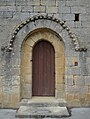
Romanesque portal
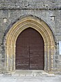
Gothic portal
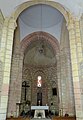
Nave, crossing and apse
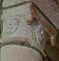
Capital with heads


- A building with a stair tower on the side dates from the 15th / 16th centuries. Century.
- A stone wayside cross from 1515 stands on the outskirts and has been recognized as a monument historique since 1948 .
Web links
- Paulin, history - photo + information (French)
- Paulin, church - photo + information (French)
- Paulin, wayside cross - aerial view, photo + brief information (French)
Individual evidence
- ^ Paulin - Map with height information
- ↑ Sarlat-la-Cenéda / Paulin - climate tables
- ↑ Église Saint-Pierre-ès-Liens, Paulin in the Base Mérimée of the French Ministry of Culture (French)
- ↑ Croix dite de la Faurie, Paulin in the Base Mérimée of the French Ministry of Culture (French)