Radford, Virginia
| Radford | ||
|---|---|---|
 Radford VA Main Street |
||
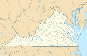
| Location in Virginia | ||
|
|
||
| Basic data | ||
| Foundation : | 1887 | |
| State : | United States | |
| State : | Virginia | |
| Coordinates : | 37 ° 8 ′ N , 80 ° 34 ′ W | |
| Time zone : | Eastern ( UTC − 5 / −4 ) | |
|
Inhabitants : - Metropolitan Area : |
16,408 (as of 2010) 157,614 (as of 2005) |
|
| Population density : | 646 inhabitants per km 2 | |
| Area : | 26.4 km 2 (approx. 10 mi 2 ) of which 25.4 km 2 (approx. 10 mi 2 ) are land |
|
| Height : | 641 m | |
| Postcodes : | 24141-24143 | |
| Area code : | +1 540 | |
| FIPS : | 51-65392 | |
| GNIS ID : | 1500073 | |
| Website : | www.radford.va.us | |
| Mayor : | Dr. Bruce Brown | |
Radford is an independent city in Virginia , United States . The city is surrounded by Montgomery County and has a population of 16,408 (2010 census). The urban area is 26.4 km², of which 1 km² (3.63%) is water and 25.4 km² is land. Radford is 641 m above sea level on the New River .
The city is home to Radford University , and north of Redford is the Radford Army Ammunition Plant .
sons and daughters of the town
- Shayne Graham (born 1977), American football player
- Richard Harding Poff (1923–2011), lawyer and politician
- Seka (* 1954), porn actress
