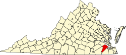
Isle of Wight County
 Isle of Wight County Courthouse |
|
| administration | |
|---|---|
| US state : | Virginia |
| Administrative headquarters : | Isle of Wight |
| Address of the administrative headquarters: |
County Courthouse P.O. Box 80 Isle of Wight, VA 23397-0080 |
| Foundation : | 1634 |
| Made up from: | Original County |
| Area code : | 001 757 |
| Demographics | |
| Residents : | 29,728 (2000) |
| Population density : | 36.3 inhabitants / km 2 |
| geography | |
| Total area : | 940 km² |
| Water surface : | 121 km² |
| map | |
| Website : www.co.isle-of-wight.va.us | |
Isle of Wight County is a county in the state of Virginia in the United States . At the 2000 census , the county had 29,728 people and a population density of 36 people per square kilometer. The county seat is Isle Of Wight .
geography
Isle of Wight County is located in southeastern Virginia, about 20 kilometers to the south from North Carolina , about 25 kilometers to the northeast from the Atlantic Ocean and has an area of 940 square kilometers, of which 121 square kilometers are water. It is bordered in a clockwise direction by the following counties: Southampton County and Surry County .
history
1634 was Warrosquyoake Shire by order of the English King Charles I founded. Shires were administrative units. The name Warrosquyoake came from an indigenous tribe . Between 1637 and 1642 the renaming of the terms shire in county took place. The Warrosquyoake shire was renamed Isle of Wight County in 1637.
Demographic data
| Population development | |||
|---|---|---|---|
| Census | Residents | ± in% | |
| 1790 | 9028 | - | |
| 1800 | 9342 | 3.5% | |
| 1810 | 9186 | -1.7% | |
| 1820 | 10.139 | 10.4% | |
| 1830 | 10,517 | 3.7% | |
| 1840 | 9972 | -5.2% | |
| 1850 | 9353 | -6.2% | |
| 1860 | 9977 | 6.7% | |
| 1870 | 8320 | -16.6% | |
| 1880 | 10,572 | 27.1% | |
| 1890 | 11,313 | 7% | |
| 1900 | 13,102 | 15.8% | |
| 1910 | 14,929 | 13.9% | |
| 1920 | 14,433 | -3.3% | |
| 1930 | 13,409 | -7.1% | |
| 1940 | 13,381 | -0.2% | |
| 1950 | 14,906 | 11.4% | |
| 1960 | 17.164 | 15.1% | |
| 1970 | 18,285 | 6.5% | |
| 1980 | 21,603 | 18.1% | |
| 1990 | 25.503 | 18.1% | |
| 2000 | 29,728 | 16.6% | |
| 2010 | 35,270 | 18.6% | |
| Before 1900
1900-1990 2000 |
|||


According to the 2000 census , the Isle of Wight County had 29,728 people. 180 people lived in collective accommodation, the other residents lived in 11,319 households and 8,670 families. The population density was 36 people per square kilometer. The racial the population was composed of 71.08 percent white, 27.15 percent African American, 0.26 percent Native American, 0.34 percent Asian, 0.03 percent from the Pacific island area and 0.28 percent from other ethnic groups Groups; 0.86 percent were from two or more races. Hispanic or Latino of any race was 0.85 percent of the population.
Of the 11,319 households, 34.0 percent had children and young people under the age of 18 living with them. 60.4 percent were married couples living together, 12.2 percent were single mothers, 23.4 percent were non-families, 20.0 percent were single households and 8.6 percent had people aged 65 years or over. The average household size was 2.61 and the average family size was 2.99 people.
For the entire county, the population was composed of 25.4 percent of residents under the age of 18, 6.6 percent between 18 and 24 years of age, 29.6 percent between 25 and 44 years of age, and 26.2 percent between 45 and 64 years of age 12.2 percent were 65 years of age or over. The median age was 39 years. For every 100 females there were 95.7 males. For every 100 women aged 18 or over there were statistically 91.7 men.
The median income for a household in the county is $ 45,387 , and the median income for a family is $ 52,597. Males had a median income of $ 37,853 versus $ 22,990 for females. The per capita income was $ 20,235. 6.6 percent of families and 8.3 percent of the population were below the poverty line. This included 8.8 percent of children and adolescents under 18 years of age and 11.9 percent of residents aged 65 and over.
Individual evidence
- ↑ Isle of Wight County in the United States Geological Survey's Geographic Names Information System . Retrieved February 22, 2011
- ^ US Census Bureau _ Census of Population and Housing . Retrieved February 28, 2011
- ↑ Extract from Census.gov . Retrieved February 28, 2011
- ↑ Excerpt from factfinder.census.gov.Retrieved February 28, 2011
- ^ Isle of Wight County, Virginia , 2000 census data sheet at factfinder.census.gov .
Web links
Coordinates: 36 ° 55 ' N , 76 ° 43' W

