Roanoke (Virginia)
| Roanoke | ||
|---|---|---|
| Nickname : The Star City of The South, Magic City | ||
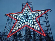
 Roanoke by Night (2003) |
||
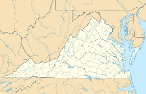
| Location in Virginia | ||
|
|
||
| Basic data | ||
| Foundation : | 1852 | |
| State : | United States | |
| State : | Virginia | |
| Coordinates : | 37 ° 16 ′ N , 79 ° 57 ′ W | |
| Time zone : | Eastern ( UTC − 5 / −4 ) | |
|
Inhabitants : - Metropolitan Area : |
99,660 (as of 2016) 313,698 (as of 2016) |
|
| Population density : | 897 inhabitants per km 2 | |
| Area : | 111.1 km 2 (approx. 43 mi 2 ) of which 111.1 km 2 (approx. 43 mi 2 ) is land |
|
| Height : | 530 m | |
| Postcodes : | 24001-24020, 24022-24038, 24040, 24042-24045, 24048, 24050, 24155, 24157 | |
| Area code : | +1 540 | |
| FIPS : | 51-68000 | |
| GNIS ID : | 1499971 | |
| Website : | www.roanokeva.gov | |
| Mayor : | David A. Bowers | |
 Downtown |
||
Roanoke [pronounced 'Rounouk'] (nicknamed The Star City of the South , the Star City of the South) is a county-level city in the US - state of Virginia . The name Roanoke comes from the Roanoke Indians who lived on the northeast coast of North Carolina in the 17th century .
history

The first explorers explored the Roanoke Valley as early as the 17th century. An expedition report from 1671 reports "blue mountains and a narrow flat valley next to the Roanoke River". However, the region was spared settlers for the next 70 years.
As the country developed east of the Blue Ridge Mountains , the first made their way to western Virginia. These early settlers were joined by like-minded people from Pennsylvania who sought new ways to live in the fertile Shenandoah Valley . The newcomers began farming in the Roanoke Valley in 1740.
As traders and new farmers settled in the region, new communities sprouted up. Botetourt County was founded in 1769, with Fincastle as its administrative center. For a short time the circle extended to the banks of the Mississippi River . Roanoke County was split off from Botetourt in 1838. In 1851, Craig County and Giles and Monroe County followed , which were separated from Botetourt County and Roanoke County.
The first settlements were established in the area that now includes the City of Roanoke at the beginning of the 19th century: Antwerp in 1801, Gainsborough in 1825 and Old Lick in 1834. Gainsborough was the most populous settlement until the Town of Big Lick was proclaimed in 1874. This small village of less than 500 people became the Town of Roanoke in 1882 and the City of Roanoke two years later . The new city was on the old Atlantic, Mississippi, and Ohio Railroad , which later became the Norfolk and Western (N&WR).
With the completion of the connection between the Shenandoah Valley Railroad from Hagerstown and the new N&WR at Roanoke, the go-ahead was given for rapid growth in the city. The neighboring town of Vinton was also founded at this time .
The place Salem , founded in 1806, became the administrative seat of the district because at the beginning of the founding period it was the largest dependent place in the area and was located on the railway line. Salem remained the main center in the area for a long time. In 1968 Salem also gained its status as an independent city.
The geographic location west of the Blue Ridge Mountains and in the middle of the valley between Maryland and Tennessee was key to the city's rapid growth. Its status as a transshipment point for all kinds of transport was also due to the headquarters of the Norfolk Southern Corporation. Nowadays, passengers and cargo are handled via the regional airport and the well-connected highway network.
The Roanoke Valley is the hub for industry, commerce, health, education, tourism, convention and entertainment in western Virginia.
Geography and climate
According to the United States Census Bureau , the city has a floor area of 111.1 km² (42.9 mi²). 111.1 km² (42.9 mi²) of which is land and 0.1 km² (0.04 mi²) is water. This corresponds to 0.07% area share of the total area.
| Roanoke, Virginia | ||||||||||||||||||||||||||||||||||||||||||||||||
|---|---|---|---|---|---|---|---|---|---|---|---|---|---|---|---|---|---|---|---|---|---|---|---|---|---|---|---|---|---|---|---|---|---|---|---|---|---|---|---|---|---|---|---|---|---|---|---|---|
| Climate diagram | ||||||||||||||||||||||||||||||||||||||||||||||||
| ||||||||||||||||||||||||||||||||||||||||||||||||
|
Average monthly temperatures and rainfall for Roanoke, Virginia
|
|||||||||||||||||||||||||||||||||||||||||||||||||||||||||||||||||||||||||||||||||||||||||||||||||||||||||
Demographics
After the census of 2000 , the city has 94,911 inhabitants, spread over 42,003 households or 24,235 families. The population density is 855 inhabitants per km² (2,213.2 / mi²). There are 45,257 residential units, which corresponds to an average of 408 per km² (1,055.3 / mi²).
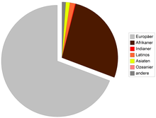
The inhabitants are based on their origin to 69.38% Europeans, 26.74% African, 1.48% Latin American, 1.15% Asians, 0.20% Indians, 0.02% Oceanians, 0.72% other, and 1.78% have two or more origins.
Of the 42,003 households, 25.5% have children under the age of 18, 37.1% are married couples, 16.5% are single women without a male partner, and 42.3% are not families. 35.9% are single households and 12.8% are single people over 65. The average household size is 2.2 and the average family size is 2.86 people.
The age distribution of the population is as follows: 22.6% are under 18, 8.2% between 18 and 24, 30.5% between 25 and 44, 22.3% between 45 and 64, and 16.4% are older than 65. The median is 38 years. For every 100 women / girls there are 88.3 men / boys. For every 100 women over 18 there are 84.3 men.
The median income per household is $ 30,719 and the median family income is $ 37,826. Males have a median income of $ 28,465 compared to $ 21,591 for women. The per capita income is $ 18,468. 15.9% of the population and 12.9% of families live below the poverty line.
- Population development
| year | 1980 | 1990 | 2000 | 2010 |
| Residents | 100,220 | 100,220 | 94,911 | 97.032 |
1980–2010: census results
Town twinning
Roanoke cultivates partnership relationships
|
sons and daughters of the town
- Tony Atlas (* 1954), professional wrestler
- Ronde Barber (born 1975), American football player
- Tiki Barber (born 1975), American football player
- Lynn Bari (1913–1989), actress
- Stephen Gould (born 1962), opera singer
- Richard Lawrence Hoffman (1927–2012), zoologist and university professor
- Slick Jones (1907-1969), jazz drummer
- John C. Mather (* 1946), astrophysicist and Nobel Prize winner 2006
- Wayne Newton (born 1942), entertainer
- John Payne (1912–1989), actor
- Charles Pillow (* ≈1960), jazz musician
- Don Pullen (1941–1995), jazz musician
- Vaughn Taylor (born 1976), professional golfer
- Vincent Stanislaus Waters (1904–1974), Bishop of Raleigh
Web links
proof
- ↑ Archived copy ( Memento of the original from May 17, 2014 in the Internet Archive ) Info: The archive link was inserted automatically and has not yet been checked. Please check the original and archive link according to the instructions and then remove this notice. Sister Cities International


